Maps of Komi

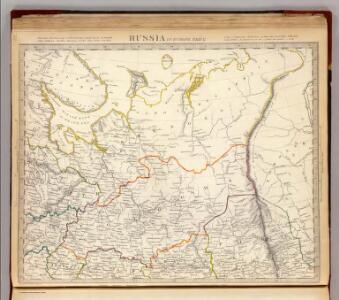
Russia in Europe. Part II.
1 : 4500000 Society for the Diffusion of Useful Knowledge (Great Britain)
Russia 2.
1 : 4435200 Letts, Son & Co.
Russie d'Europe / par J.B. Poirson Ingénieur Géog.e
1 : 10000000 1 Karte : Kupferdruck ; 18 x 24 cm Poirson, Jean-Baptiste [Verlag nicht ermittelbar]
Carte de la Russie d'Europe / par J.B. Poirson ; gravé par Tardieu
1 : 9000000 1 Karte auf 2 Blatt : Kupferdruck ; 39 x 27 cm Poirson, Jean-Baptiste [Mentelle]
[Ost-Europa in 6 Blättern, Blatt 2]
Handatlas über alle Theile der Erde und über das Weltgebäude Stieler, Adolf Justus Perthes
[Ost-Europa in 6 Blättern, Enthaltend: Norwegen, Schweden, Russland, Kaukasien und die Türkei, Blatt 2]
Hand-Atlas über alle Theile der Erde und über das Weltgebäude Stieler, Adolf Justus Perthes
Russian Dominions
A new general atlas of modern geography, consisting of a complete collection of maps of the four quarters of the globe Wyld, James James Wyld
[Ost-Europa, Blatt 2]
Adolf Stieler's Handatlas über alle Theile der Erde und über das Weltgebäude Stieler, Adolf Justus Perthes
Karta Pomorskago kraja v 17 věkě
Russland Russland (Nord)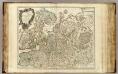
Russie Europeenne sud.
1 : 3350000 Robert de Vaugondy, Gilles, 1688-1766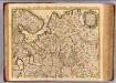
Moscovie.
1 : 2600000 L'Isle, Guillaume de, 1675-1726
16-17. RSFSR (Russian Soviet Federated Socialist Republic) in Europe, North. The World Atlas.
1 : 3000000 USSR (Union of Soviet Socialist Republics).
Ost-Europa, Bl. 2: Nordost-Russland.
1 : 3700000 Petermann, A.
Des europäischen Russlands nördlicher Theil
Allgemeiner Atlas [Walch, Johannes] im Verlag bei Johannes Walch

Russie européenne; partie septentrionale / Tardieu sculp. ; André scrip
1 : 5300000 1 Karte : Kupferdruck ; 31 x 41 cm Mentelle, Edme [Mentelle]
Carte nouvelle de Moscovie / dressée par G. de L'Isle
1 : 3200000 1 Karte : Kupferdruck ; 40 x 55 cm L'Isle, Guillaume de chés Ian B. Elwe
(Europaischen Russland II).
1 : 5000000 Berghaus, Heinrich; Flemming, Carl; Handtke, Friedrich H.; Sohr, Karl

Zweiter Theil der Karte von Europa welcher Dænemark, und Norwegen, Schweden, und Russland enthælt, 1
1 Blatt : 72 x 53 cm F.A. Schrämbl
Seconde partie de la carte d'Europe contenant le Danemark et la Norwege, la Suède et la Russie (a l'exeption de l'Ukraine), 1
1 Blatt : 71 x 53 cm chez l'auteur
Mappae Imperii Moscovitici pars Septentrionalis
1 : 2600000 adornata per Guillielmum De L'Isle nunc vero aeri incisa et venalis exposita a Matth. Seutter Aug. [Vindelicorum] : Matt. Seutter
Nouvelle carte des etats du grand duc de Moscovie en Europe partie sertentrionale [sic]
1 : 3700000 1 Karte : Kupferdruck ; 34 x 45 cm Châtelain, Zacharias [Verlag nicht ermittelbar]
Geologičeskaja karta Evropejskoj Rossii
1 : 2500000 Nordost-Blatt Karpinskij, A.P. (Aleksandr Petrovič) Kartografičeskoe zavedenie A.Il'ina
Partie septentrionale de la Russie européenne / par Robert de Vaugondy ; corrigée par le C.en Lama
1 : 7400000 1 Karte : Kupferdruck ; 23 x 30 cm Delamarche, Charles François [Verlag nicht ermittelbar]
Partie septentrionale de la Russie européenne / d'aprés le détail de l'Atlas Russien par le Sr. R
1 : 3400000 1 Karte auf 2 Blatt : Kupferdruck ; 47 x 58 cm Robert de Vaugondy, Didier [Verlag nicht ermittelbar]
Moscovey in Europe / by I. Senex
1 : 4200000 1 Karte auf 2 Blatt : Kupferdruck ; 58 x 49 cm Senex, John [John Senex]