Maps of Komi

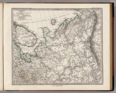
Ost-Europa, Bl. 2: Nordost-Russland.
1 : 3700000 Petermann, A.
[Ost-Europa in 6 Blättern, Enthaltend: Norwegen, Schweden, Russland, Kaukasien und die Türkei, Blatt 2]
Hand-Atlas über alle Theile der Erde und über das Weltgebäude Stieler, Adolf Justus Perthes
[Ost-Europa, Blatt 2]
Adolf Stieler's Handatlas über alle Theile der Erde und über das Weltgebäude Stieler, Adolf Justus Perthes
Russie d'Europe / par J.B. Poirson Ingénieur Géog.e
1 : 10000000 1 Karte : Kupferdruck ; 18 x 24 cm Poirson, Jean-Baptiste [Verlag nicht ermittelbar]
Carte de la Russie d'Europe / par J.B. Poirson ; gravé par Tardieu
1 : 9000000 1 Karte auf 2 Blatt : Kupferdruck ; 39 x 27 cm Poirson, Jean-Baptiste [Mentelle]
Russia in Europe. Part II.
1 : 4500000 Society for the Diffusion of Useful Knowledge (Great Britain)
Geologičeskaja karta Evropejskoj Rossii
1 : 2500000 Nordost-Blatt Karpinskij, A.P. (Aleksandr Petrovič) Kartografičeskoe zavedenie A.Il'ina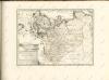

Russia 2.
1 : 4435200 Letts, Son & Co.
16-17. RSFSR (Russian Soviet Federated Socialist Republic) in Europe, North. The World Atlas.
1 : 3000000 USSR (Union of Soviet Socialist Republics).
Russie Europeenne sud.
1 : 3350000 Robert de Vaugondy, Gilles, 1688-1766
(Europaischen Russland II).
1 : 5000000 Berghaus, Heinrich; Flemming, Carl; Handtke, Friedrich H.; Sohr, Karl
Karta Pomorskago kraja v 17 věkě
Russland Russland (Nord)
Geognostisch-geographische Übersicht des Petschora Landes
Pečora, řeka (Rusko) Keyserling, Alexander Krusenstern, Paul von
Geognostisch-geographische Übersicht des Petschora Landes
Pečora, řeka (Rusko) Keyserling, Alexander Krusenstern, Paul von
[IV], uit: Geognostische Karte des Oesterreichischen Kaiserstaates mit einem grossen Theile Deutschland's u. Italien / hauptsachlich nach ... Haidinger's geognostischer Karte dieses Staates bearb. von Josef Scheda
1 : 3000000 titelvariant: General-Karte von Europa in 25 Blättern; Annotatie: Bijlage bij: General-Karte von Europa in 25 Blättern. - 1:2.592.000. - 1845-1847 Scheda, Joseph Wien : K.K. Militär. Geografisch. Institut
Moscovie.
1 : 2600000 L'Isle, Guillaume de, 1675-1726
Carte nouvelle de Moscovie / dressée par G. de L'Isle
1 : 3200000 1 Karte : Kupferdruck ; 40 x 55 cm L'Isle, Guillaume de chés Ian B. Elwe

Governo di Arcangelo, e sue provincie nella Russia europea / G. Zuliani inc. ; G. Pitteri scr
1 : 3500000 1 Karte : Kupferdruck ; 42 x 33 cm Zuliani, Giuliano presso Antonio Zatta
Moscovie (nord)
1 : 2600000 L'Isle, Guillaume de, 1675-1726
Russiæ et Novæ Zemlæ maritimæ
1 Karte : Kupferdruck ; 48 x 56 cm Renard Louis Renard
Mappæ imperii Moscovitici pars septentrionalis
1 Karte : Kupferdruck ; 48 x 56 cm Seutter; L'Isle Matthäus Seutter
Mappae imperii Moscovitici pars septentrionalis / adornata per Guillielmum de l'Isle membrum Academi
1 : 2600000 1 Karte : Kupferdruck ; 48 x 56 cm Seutter, Matthäus anjezo bey Johañ Michael Probst
Mappae imperii Moscovitici pars septentrionalis / adornata per Guillielmum de l'Isle membrum Academi
1 : 2600000 1 Karte : Kupferdruck ; 48 x 56 cm Seutter, Matthäus [Matthäus Seutter]
Feuille 6 (F I), uit: Carte géologique internationale de l'Europe : la carte, votée au congrès géologique international de Bologne en 1881, est exécutée conformément aux décisions d'une commission internationale, avec le concours des gouvernements, sous le dir. de M.M. Beyrich et Hauchecorne
Annotatie: Blad 48 gamme des couleurs; blad 49: bladwijzer en titelblad Heinrich Ernst Beyrich 1815-1896; Wi. Hauchecorne Berlin : Reimer / (Berlin: Institut lithographique)
Voenno-dorožnaja karta časti Rossii i pograničnych zemelʹ
1 : 1680000 Karelien, Pomor'e Šubert [Generalmajor]
[128][131] Russiae et Novae Zemlae Maritimae, uit: Atlas sive Descriptio terrarum orbis
Annotatie: Gedigitaliseerde versie. Amsterdam. Heiloo : Picturae (vervaardiger), 2015. tiff-bestand. Gedigitaliseerd: 07-01-2015; Origineel: Universiteitsbibliotheek Vrije Universiteit (XL.05127.-) ; Netherlands; Titelpagina ontbreekt Wit, Frederik de Amsterdam : Frederick de Wit