Maps of Oparinsky District

Maps of Oparinsky District

$title$

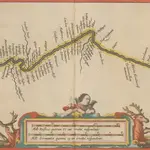
Dwinae Fluvii. nova descriptio. [Karte, Teil 2], in: Novus atlas absolutissimus, Bd. 1, S. 81.

1 Karte aus Atlas Janssonius Offizin
$title$

Dwinae Fluvii. nova descriptio. [Karte, Teil 3], in: Novus atlas absolutissimus, Bd. 1, S. 81.

1 Karte aus Atlas Janssonius Offizin
$title$

Voenno-dorožnaja karta časti Rossii i pograničnych zemelʹ

1 : 1680000 Karelien, Pomor'e Šubert [Generalmajor]
$title$

Partie, Russie d'Europe. Europe 6.

1 : 1641836 Vandermaelen, Philippe, 1795-1869
$title$

Dwinae fluvii nova descripto

1 : 637000 Janssonius van Waesberge, Johannes Pitt, Moses Mosis Pitt
$title$

Dwinae fluvii nova descripto

1 : 637000 Janssonius, Johannes apud Joannem Janßonium
$title$

Dwinæ fluvii nova descriptio

1 : 640000 1 Karte in 3 Teilen auf 1 Blatt : Kupferdruck ; 46 x 54 cm Janssonius van Waesbergen, Johannes sumptibus Janssonio-Waesbergiorum et Mosis Pitt
$title$

Itäinen Aunus

1 : 1000000 Olonec (Rusko : oblast) Tilgmannin kivipaino
$title$

Dwinae Fluvii. nova descriptio. [Karte, Teil 1], in: Novus atlas absolutissimus, Bd. 1, S. 81.

1 Karte aus Atlas Janssonius Offizin
$title$

DWINA FLVVIVS.

[Amsterdam : Joan Blaeu]
$title$

Bez titulu: Slobodskoj a okolí

$title$

Governo di Arcangelo, e sue provincie nella Russia europea / G. Zuliani inc. ; G. Pitteri scr

1 : 3500000 1 Karte : Kupferdruck ; 42 x 33 cm Zuliani, Giuliano presso Antonio Zatta
$title$

La Moscovie septentrionale, suivant les nouvelles observations de Messrs. de L'Académie Royale de S

1 : 5800000 1 Karte : Kupferdruck ; 21 x 29 cm chez Covens et Mortier
$title$

La Moscovie septentrionale, suivant les nouvelles observations de Messrs. de L'Académie Royale de S

1 : 5800000 1 Karte : Kupferdruck ; 21 x 29 cm chez Covens et Mortier
$title$

Nouvelle carte des etats du grand duc de Moscovie en Europe partie sertentrionale [sic]

1 : 3700000 1 Karte : Kupferdruck ; 34 x 45 cm Châtelain, Zacharias [Verlag nicht ermittelbar]
$title$

Moscovie.

1 : 2600000 L'Isle, Guillaume de, 1675-1726
$title$

Carte nouvelle de Moscovie / dressée par G. de L'Isle

1 : 3200000 1 Karte : Kupferdruck ; 40 x 55 cm L'Isle, Guillaume de chés Ian B. Elwe
$title$

Ost-Europa, Bl. 2: Nordost-Russland.

1 : 3700000 Petermann, A.
$title$

[Ost-Europa, Blatt 2]

Adolf Stieler's Handatlas über alle Theile der Erde und über das Weltgebäude Stieler, Adolf Justus Perthes
$title$

Mappae Imperii Moscovitici pars Septentrionalis

1 : 2600000 adornata per Guillielmum De L'Isle nunc vero aeri incisa et venalis exposita a Matth. Seutter Aug. [Vindelicorum] : Matt. Seutter
$title$

$title$

Russia 2.

1 : 4435200 Letts, Son & Co.
$title$

Partie septentrionale de la Russie européenne / par Robert de Vaugondy ; corrigée par le C.en Lama

1 : 7400000 1 Karte : Kupferdruck ; 23 x 30 cm Delamarche, Charles François [Verlag nicht ermittelbar]
$title$

Partie septentrionale de la Russie européenne / d'aprés le détail de l'Atlas Russien par le Sr. R

1 : 3400000 1 Karte auf 2 Blatt : Kupferdruck ; 47 x 58 cm Robert de Vaugondy, Didier [Verlag nicht ermittelbar]
$title$

[Ost-Europa in 6 Blättern, Enthaltend: Norwegen, Schweden, Russland, Kaukasien und die Türkei, Blatt 2]

Hand-Atlas über alle Theile der Erde und über das Weltgebäude Stieler, Adolf Justus Perthes
$title$

Geologičeskaja karta Evropejskoj Rossii

1 : 2500000 Nordost-Blatt Karpinskij, A.P. (Aleksandr Petrovič) Kartografičeskoe zavedenie A.Il'ina
$title$

Russia in Europe. Part II.

1 : 4500000 Society for the Diffusion of Useful Knowledge (Great Britain)
$title$

Zweiter Theil der Karte von Europa

1 : 2870000 Dánsko Anville, Jean-Baptiste Bourguinon d' Benedicti, Hieronymus F.A. Schraembl
$title$

Karta Pomorskago kraja v 17 věkě

Russland Russland (Nord)
$title$

(Europaischen Russland II).

1 : 5000000 Berghaus, Heinrich; Flemming, Carl; Handtke, Friedrich H.; Sohr, Karl
© MapTiler © OpenStreetMap contributors
How does it work?
These instructions will show you how to find historical maps online.
Getting started
Type the place name in the search box to find the exact location. You can further adjust the search by zooming in and out.
Zoom
Zoom in and out with the buttons or use your mouse or touchpad natively.
Exact Area tool
Click here and draw a rectangle over the map to precisely define the search area.
Set filters
Narrow your search with advanced settings, such as Years (from/to), Fulltext, Publisher, etc.
Results
See the results of your search on the right side. You can scroll down to find more maps of this location.
?

Download OldMapsOnline Mobile