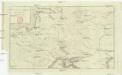
Maps of Pontic Steppe

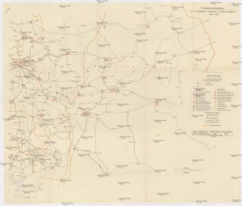
Friedensdislokation im europäischen Russland
1 : 2800000 Rusko západní
[Moscowyter land]
1 : 7700000 1 Karte : Kupferdruck ; 16 x 18 cm Münster, Sebastian [Henricpetri]
Moscouia
1 : 7700000 1 Karte : Kupferdruck ; 16 x 18 cm Münster, Sebastian [Henricpetri]
[Moscowyter land]
1 : 7700000 1 Karte : Kupferdruck ; 16 x 18 cm Münster, Sebastian [Henricpetri]
Postkarte von Süd Russland
Rusko západní Stenger, Johann im von Reillyschen Landkarten und Kunstwerke Verschleiss Komptoir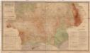
Gipsometričeskaja karta Jevropejskoj Rossii
1 : 2500000 Rusko západní Tillo, Alexis Kartografičeskoje zavedenije A. Il'jina
Geologičeskaja karta Evropejskoj Rossii
1 : 2500000 Ostblatt Karpinskij, A.P. (Aleksandr Petrovič) Kartografičeskoe zavedenie A.Il'ina
Russia 7.
1 : 5068800 Letts, Son & Co.
[X], uit: Geognostische Karte des Oesterreichischen Kaiserstaates mit einem grossen Theile Deutschland's u. Italien / hauptsachlich nach ... Haidinger's geognostischer Karte dieses Staates bearb. von Josef Scheda
1 : 3000000 titelvariant: General-Karte von Europa in 25 Blättern; Annotatie: Bijlage bij: General-Karte von Europa in 25 Blättern. - 1:2.592.000. - 1845-1847 Scheda, Joseph Wien : K.K. Militär. Geografisch. Institut
Russia in Europe Part VII.
1 : 4300000 Society for the Diffusion of Useful Knowledge (Great Britain)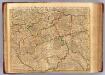
Moscovie Meridionale.
1 : 2600000 L'Isle, Guillaume de, 1675-1726
Ostrussland
1 : 2000000 Rusko Kartographische Anstalt Freytag-Berndt u. Artaria
Ost-Europa, No. 4: Central-Russland.
1 : 3700000 Petermann, A.
[Ost-Europa in 6 Blättern, Blatt 4]
Handatlas über alle Theile der Erde und über das Weltgebäude Stieler, Adolf Justus Perthes
[Ost-Europa in 6 Blättern, Enthaltend: Norwegen, Schweden, Russland, Kaukasien und die Türkei, Blatt 4]
Hand-Atlas über alle Theile der Erde und über das Weltgebäude Stieler, Adolf Justus Perthes
[Ost-Europa, Blatt 4]
Adolf Stieler's Handatlas über alle Theile der Erde und über das Weltgebäude Stieler, Adolf Justus Perthes
Administrativnaja Karta Evropejskoj časti C.C.C.P.

[Nižnjaja Volga]
Volha-oblast (Rusko)
Feuille 20 (F III), uit: Carte géologique internationale de l'Europe : la carte, votée au congrès géologique international de Bologne en 1881, est exécutée conformément aux décisions d'une commission internationale, avec le concours des gouvernements, sous le dir. de M.M. Beyrich et Hauchecorne
Annotatie: Blad 48 gamme des couleurs; blad 49: bladwijzer en titelblad Heinrich Ernst Beyrich 1815-1896; Wi. Hauchecorne Berlin : Reimer / (Berlin: Institut lithographique)
Rvssiæ, vulgo Moscovia, pars australis / auctore Isaaco Massa
1 : 3910000 1 Karte : Kupferdruck ; 38 x 51 cm Blaeu, Joan Apud Johan et Cornelium Blaeu
Tabvla Asiae II
1 : 7900000 1 Karte : Holzschnitt ; 26 x 33 cm Münster, Sebastian [Bey den Henricpetrinischen]
Karte vom Ural Gebirge, gegründet auf die astronomischen Beobachtungen von Wischnewsky, Schubert, A. v. Humboldt, Ad. Erman, und auf handschriftliche Specialkarten
1 : 2000000 [S.l.] : [s.n.]
Schema historických momentů československ. vojenských operací na Sibiři 1918-1919
Moscovia, pars avstralis / auctore Isaaco Massa
1 : 3700000 1 Karte : Kupferdruck ; 36 x 48 cm Massa, Isaac Abrahamsz typis apud P. Schenk et G. Valk
Partie méridionale de la Russie européenne / d'aprés le détail de l'Atlas Russien
1 : 3500000 1 Karte : Kupferdruck ; 46 x 58 cm Santini, François chez François Santini rue St. Justine près de l'Eglise
Rvssiæ, vulgo Moscovia, pars australis / auctore Isaaco Massa
1 : 3957000 Annotatie: Met wapen; Origineel is Blad 137 in atlas factice; Annotatie geografische gegevens: Met 2 schaalstokken Isaac Abrahamszoon Massa 1586-1643 [Amsterdam : apud Johan. et Cornelium Blaeu]
Governi di Moscovia e Woronez colle loro provincie nella Russia europea
1 Karte : Kupferdruck ; 41 x 32 cm Zatta; Zuliani; Pitteri presso Antonio Zatta
Governi di Moscovia e Woronez colle loro provincie nella Russia europea / G. Zuliani inc. ; G. Pitte
1 : 3500000 1 Karte : Kupferdruck ; 41 x 32 cm Zuliani, Giuliano presso Antonio Zatta
I governi di Moscovia e Woronez nell'impero della Russia in Europa / Gio. Ma. Cassini som.co. inc.
1 : 3500000 1 Karte : Kupferdruck ; 44 x 31 cm Cassini, Giovanni Maria Presso la Calcografia Camerale