Maps of Pontic Steppe
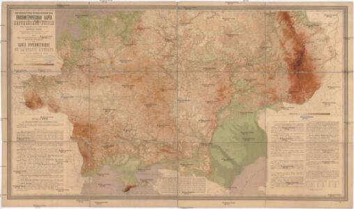
Gipsometričeskaja karta Jevropejskoj Rossii
1 : 2500000 Rusko západní Tillo, Alexis Kartografičeskoje zavedenije A. Il'jina
Postkarte von Süd Russland
Rusko západní Stenger, Johann im von Reillyschen Landkarten und Kunstwerke Verschleiss Komptoir
Tabula Asiae II. [Karte], in: Geographia universalis vetus et nova complectens Claudii Ptolemaei Alexandrini enarrationis libros VIII, S. 269.
1 Karte aus Atlas Münster, Sebastian [und Ptolemaeus, Claudius]
Schematičeskaja karta uězdov evropejskoj Rossīi. Ostatok vsěch chlěbov i kartofelja
Russland Russland Landwirtschaft Statistik Petrovskij, A.N.
Schematičeskaja karta uězdov evropejskoj Rossīi. Urožaja jačmenja "sam " za 1885 g.
Russland Russland Landwirtschaft Statistik Petrovskij, A.N.
Schematičeskaja karta uězdov evropejskoj Rossīi. Ostatok rži i pšenicy (ozimoj i jarovoj)
Russland Russland Landwirtschaft Statistik Petrovskij, A.N.
Schematičeskaja karta uězdov evropejskoj Rossīi. Ostatok vsěch chlěbov , kromě kartofelja
Russland Russland Landwirtschaft Statistik Petrovskij, A.N.
Schematičeskaja karta uězdov evropejskoj Rossīi. Urožaja ovsa s desjatiny za 1885 g.
Russland Russland Landwirtschaft Statistik Petrovskij, A.N.
Neue Post-Karte von Russland herausgegeben vom moscowschen Ober Post Amt
1 : 4300000 Evropa východní Knittel, I. E. Campe, Friedrich Friedrich Campe
Schematičeskaja karta uězdov evropejskoj Rossīi. Ostatok jarovych chlěbov , bez pšenicy i ovsa
Russland Russland Landwirtschaft Statistik Petrovskij, A.N.
Schematičeskaja karta uězdov evropejskoj Rossīi. Urožaja rži s desjatiny za 1885 g.
Russland Russland Landwirtschaft Statistik Petrovskij, A.N.
Schematičeskaja karta uězdov evropejskoj Rossīi. Ostatok kartofelja na 1 dušu ob. pola za 1885 g.
Russland Russland Landwirtschaft Statistik Petrovskij, A.N.
Schematičeskaja karta uězdov evropejskoj Rossīi. Urožaja jačmenja s desjatiny za 1885 g.
Russland Russland Landwirtschaft Statistik Petrovskij, A.N.
Schematičeskaja karta uězdov evropejskoj Rossīi. Urožaja ovsa "sam " za 1885 g.
Russland Russland Landwirtschaft Statistik Petrovskij, A.N.
Schematičeskaja karta uězdov evropejskoj Rossīi. Ostatok vsěch jarovych chlěbov
Russland Russland Landwirtschaft Statistik Petrovskij, A.N.
Anbau u. Juli-Jsothermen
Russland / Europäischer Teil Pflanzenbau, Klima
Russia In Europe.
1 : 12672000 Finley, Anthony
Moscoviae imperium
1 : 18500000 1 Karte : Kupferdruck ; 12 x 17 cm Ptolemaeus, Claudius [Giovanni B. u. Georgio Galignani]
Russie D'Europe
Nouvel atlas physique politique et historique de l'Empire ottoman et des états limitrophes en Europe, en Asie et en Afrique, en quarante feuilles Hellert, J.J. Bellizard, Dufour et Cie
Sarmatia.
1 : 22000000 Fenner, Rest.
Karta Evropejskoj Rossīi s pokazanīem urožaja jačmenja za 1884 god
Russland Russland Landwirtschaft Statistik Zverinskij, V.V.; Petrovskij, A.N.
Karta Evropejskoj Rossīi s pokazanīem urožaja ovsa s 1 desjatiny
Russland Russland Landwirtschaft Statistik Zverinskij, V.V.; Petrovskij, A.N.
Russia in Europe / Engd. by J. Moffat, Edinr.
1 : 5300000 1 Karte : Kupferdruck ; 57 x 47 cm Moffat, John John Thomson & Co., 1818]
Karta Evropejskoj Rossīi s pokazanīem ostatka chlěbov , kromě kartofelja na 1 dušu ob. Pola
Russland Russland Landwirtschaft Statistik Zverinskij, V.V.; Petrovskij, A.N.
Schematičeskaja karta uězdov evropejskoj Rossīi. Urožaja rži "sam " za 1885 g.
Russland Russland Landwirtschaft Statistik Petrovskij, A.N.
Russland von der Verlegung des Russischen Grossfürstenthums nach Moskau, 1328, und der Gründung des Grossfürstenthums Litthauen bis zur Vernichtung der Goldenen Horde, 1480
1 : 12000000 Großfürstentum Litauen, Moskauer Reich
Karta Evropejskoj Rossīi s pokazanīem ostatka bez chlěbov ovsa i kartofelja na 1 dušu ob. pola
Russland Russland Landwirtschaft Statistik Zverinskij, V.V.; Petrovskij, A.N.
Secunda Asie Tabula [Karte], in: [Clavdii Ptholomei Cosmographi ...], S. 302.
1 Karte aus Atlas Nicolaus Germanus [und Ptolemaeus, Claudius]
Karta Evropejskoj Rossīi s pokazanīem urožaja jarovoj pšenicy za 1884 god
Russland Russland Landwirtschaft Statistik Zverinskij, V.V.; Petrovskij, A.N.