Maps of Volga Upland

Maps of Volga Upland

$title$

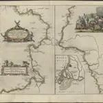
NOVA & ACCVRATA | WOLGÆ FLVMINIS

olim RHA dicti, | DELINEATIO | Auctore | ADAMO OLEARIO. [Amsterdam : Joan Blaeu]
$title$

Nova Et Accurata Wolgae Fluminis, olim RHA dicti Delineatio [Karte, Teil 1], in: Novus atlas absolutissimus, Bd. 1, S. 87.

1 Karte aus Atlas Janssonius Offizin
$title$

Obščaja geologičeskaja karta evropejskoj Rossii : List 92: Saratov - Penza

1 : 420000 sostavili I. Sintsov i S. Nikitin = Carte géologique générale de la Russie d'Europe : Feuille 92: Saratov - Pensa dressée par I. Sintzov et S. Nikitin [S.l.] : [s.n.]
$title$

Izměnenīja za stolětīe v tečenīi rěki Sury pod Penzoj : Konec XVIII věka

Russland Pensa Umland Flusslaufverlegung
$title$

Izměnenīja za stolětīe v tečenīi rěki Sury pod Penzoj : Konec XIX věka

Russland Pensa Umland Flusslaufverlegung
$title$

General'nyj plan Nižegorodskoj Makar'jevskoj Jarmorki s pokazanijem na onom gostin[n]ago dvora i vsěch vremjannych poměščenij

1 : 4000 Nižnij Novgorod (Rusko) Milanov, N. izdannyj kandidatom kommercii N. Milanovym
$title$

Plansc jarmaročnago gostinago dvora, 1833

Moskva : Lozunova
$title$

Feuille 20 (F III), uit: Carte géologique internationale de l'Europe : la carte, votée au congrès géologique international de Bologne en 1881, est exécutée conformément aux décisions d'une commission internationale, avec le concours des gouvernements, sous le dir. de M.M. Beyrich et Hauchecorne

Annotatie: Blad 48 gamme des couleurs; blad 49: bladwijzer en titelblad Heinrich Ernst Beyrich 1815-1896; Wi. Hauchecorne Berlin : Reimer / (Berlin: Institut lithographique)
$title$

[Nižnjaja Volga]

Volha-oblast (Rusko)
$title$

U.S.S.R. in Europe - Central. Pergamon World Atlas.

1 : 2500000 Polish Army Topography Service
$title$

Voenno-dorožnaja karta časti Rossii i pograničnych zemelʹ

1 : 1680000 Zentralrussland, Moskau Šubert [Generalmajor]
$title$

Le cours de la riviere de Wolga, anciennement appellée Rha selon la relation d'Olearius / a Leide p

1 : 2500000 1 Karte : Kupferdruck ; 23 x 58 cm Olearius, Adam chez J. Covens et C. Mortier
$title$

Nova et accurata Wolgæ fluminis olim Rha dicti delineatio / auctore Adamo Oleario

1 : 1300000 1 Karte in 3 Teilen : Kupferdruck ; 48 x 57 cm Olearius, Adam [Verlag nicht ermittelbar]
$title$

Nova et accurata Wolgæ fluminis olim Rha dicti delineatio / auctore Adamo Oleario

1 : 1400000 1 Karte in 2 Teilen : Kupferdruck ; 47 x 55 cm Janssonius van Waesbergen, Johannes Janssonius-Waesbergius et Moses Pitt
$title$

Otčetnaja karta pochoda Īoanna Groznago pod Kazan' v 1552 g.

Russland Khanat Kasan Kasan Krieg Iwan IV.
$title$

Partie, Russie d'Europe. Europe 11.

1 : 1641836 Vandermaelen, Philippe, 1795-1869
$title$

Berg- und Wiesenufer von Saratow

1 : 2000000 Saratow
$title$

Mittlerer Theil des Saratowschen Gouvernements mit den deutschen Colonieen

Russland, Saratow (Gouvernement), Wolgadeutsche
$title$

Ostrussland

1 : 2000000 Rusko Kartographische Anstalt Freytag-Berndt u. Artaria
$title$

Russia in Europe Part VII.

1 : 4300000 Society for the Diffusion of Useful Knowledge (Great Britain)
$title$

[Ost-Europa, Blatt 4]

Adolf Stieler's Handatlas über alle Theile der Erde und über das Weltgebäude Stieler, Adolf Justus Perthes
$title$

Ost-Europa, No. 4: Central-Russland.

1 : 3700000 Petermann, A.
$title$

Russia 7.

1 : 5068800 Letts, Son & Co.
$title$

19-20. RSFSR (Russian Soviet Federated Socialist Republic) in Europe, Central. The World Atlas.

1 : 3000000 USSR (Union of Soviet Socialist Republics).
$title$

[Ost-Europa in 6 Blättern, Enthaltend: Norwegen, Schweden, Russland, Kaukasien und die Türkei, Blatt 4]

Hand-Atlas über alle Theile der Erde und über das Weltgebäude Stieler, Adolf Justus Perthes
$title$

La Moscovie meridionale, suivant les nouvelles observations de Messrs. de L'Académie Royale de Scie

1 : 5800000 1 Karte : Kupferdruck ; 21 x 29 cm chez Pierre van der AA
$title$

La Moscovie meridionale, suivant les nouvelles observations de Messrs. de L'Académie Royale de Scie

1 : 5800000 1 Karte : Kupferdruck ; 21 x 29 cm chez Pierre van der AA
$title$

La Moscovie meridionale, suivant les nouvelles observations de Messrs. de L'Académie Royale de Scie

1 : 5800000 1 Karte : Kupferdruck ; 21 x 29 cm chez Covens et Mortier
$title$

La Moscovie meridionale, suivant les nouvelles observations de Messrs. de L'Académie Royale de Scie

1 : 5800000 1 Karte : Kupferdruck ; 21 x 29 cm chez Covens et Mortier
$title$

[Ost-Europa in 6 Blättern, Blatt 4]

Handatlas über alle Theile der Erde und über das Weltgebäude Stieler, Adolf Justus Perthes
© MapTiler © OpenStreetMap contributors
How does it work?
These instructions will show you how to find historical maps online.
Getting started
Type the place name in the search box to find the exact location. You can further adjust the search by zooming in and out.
Zoom
Zoom in and out with the buttons or use your mouse or touchpad natively.
Exact Area tool
Click here and draw a rectangle over the map to precisely define the search area.
Set filters
Narrow your search with advanced settings, such as Years (from/to), Fulltext, Publisher, etc.
Results
See the results of your search on the right side. You can scroll down to find more maps of this location.
?

Download OldMapsOnline Mobile