Maps of Monmouth County

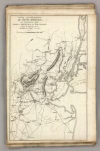
Septentrionale du New Jersey, et Positions des Armees Americaine et Britannique en 1776.
1 : 300000 Marshall, John
Northern Part of New Jersey, shewing the the American and British Armies after crossing the North River in 1776.
1 : 290000 Marshall, John
A plan of the northern part of New Jersey : shewing the positions of the American and British armies after crossing the North River in 1776 / drawn by S. Lewis from surveys by order of Gen. Washington ; engrav'd by Fs. Shallus.
from Revolutionary War, 1775-1783
Map of the country thirty miles round the city of New York
1 : 190080 Disturnell, John, 1801-1877 J. Disturnell
Map of Staten Island o Richmond County. 16 views of buildings on border. Also view of Elliottville the property of Dr. S. M. Elliott.
From Staten Island
General map of the city of New York, consisting of boroughs of Manhattan, Brooklyn, Bronx, Queens and Richmond : consolidated into one municipality by act of the legislature of the state of New York (Chapter 378 of the laws of 1897) : showing in addit...
From Whole
Map ... Around The City Of New York.
1 : 205920 Colton, J. H.
Map Of The Country Thirty Miles Round the City of New York.
1 : 190080 Eddy, John H.
Boroughs of Manhattan and Bronx, showing the electric service of the New York Edison Co.
From Manhattan
Vingboons map of Manhattan, 1639 : a facsimile from the Library of Congress.
from Whole
United States--east coast, New York--New Jersey, New York Harbor / Coast Survey.
from New York harbor
Map no. III : [to accompany A bill in the chancery of New-Jersey, at the suit of John, Earl of Stair ... against Benjamin Bond].
from A bill in the chancery of New-Jersey, at the suit of John earl of Stair, and others, proprietors of the eastern-division of New-Jersey; against Benjamin Bond. and some other persons of Elizabeth-Town, distinguished by the name of the Clinker lot right men. With three large maps, done from copper-plates. To which is added; the publications of the Council of proprietors of East New-Jersey, and Mr. Nevill's speeches to the General assembly, concerning the riots committed in New-Jersey, and the pretences of the rioters, and their seducers. These papers will give a better light into the history and constitution of New-Jersey, than any thing hitherto published, the matters whereof have been chiefly collected from records. Published by subscription:
Map of the Country Twenty Five Miles Round The City Of New-York.
1 : 300000 Greenleaf, Jeremiah
Map of the Country Twenty Five Miles Round The City Of New-York.
1 : 316800 Greenleaf, Jeremiah
Map of New-York and its vicinity /drawn by D.H. Burr, geographer ; engraved by S. Stiles, Sherman & Smith.
from New York harbor
Line of the Morris Canal, New Jersey, 1827 / Desobry fecit.
from Cities and towns
Linear development concept for Morrisania
From District 3
Atlas of New Jersey : Counties of Essex, Union, and Hudson.
from Combined atlas of the State of New Jersey and the County of Hudson : from actual survey, official records & private plans / by and under the direction of G. M. Hopkins ...
Map of the Country Twenty Five Miles Round The City Of New-York.
1 : 211200 Burr, David H., 1803-1875
Nature's estuary: the historic tidelands of the New York New Jersey harbor estuary / cartographic design by Jennifer Cox; cartographers George Colbert and Guenter Vollath.
Jennifer Cox; George Colbert; Guenter Vollath,
Map of New York City, (Greater New York).
From Manhattan
A plan of New York Island, with part of Long Island, Staten Island & east New Jersey : with a particular description of the engagement on the woody heights of Long Island, between Flatbush and Brooklyn, on the 27th of August 1776 between His Majesty'
from Cartographic materials from the Emmet Collection of Manuscripts Etc. Relating to American History.
Hammond's complete map of Brooklyn.
From Brooklyn
New York and vicinity [map]
1 : 24000 Geological Survey (U.S.) Geological Survey
Chart and plan of the harbour of New York & the couny. adjacent, from Sandy Hook to Kingsbridge : comprehending the whole of New York and Staten Islands, and part of Long Island & the Jersey shore, and shewing the defences of New York both by land and se
from Whole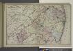
Topographical Map of Monmouth Co., New Jersey.
from Atlas of Monmouth co., New Jersey. From recent and actual surveys and records, under the superintendence of F.W. Beers.
New Jersey, Double Page Sheet No. 7 [Map of Northeastern Red Sandstone]
From Atlas of New Jersey.
A plan of the city of New-York & its environs : to Greenwich, on the North or Hudsons River, and to Crown Point, on the East or Sound River, shewing the several streets, publick buildings, docks, fort & battery, with the true form & course of the command
from Charts and maps
Index to Sectional aerial maps of the City of New York / [photographed and assembled under the direction of the chief engineer, July 1st, 1924].
from Sectional aerial maps of the City of New York / [photographed and assembled under the direction of the chief engineer, July 1st, 1924].