Maps of New York

Linear development concept for Morrisania
From District 3
Map of the Country Twenty Five Miles Round The City Of New-York.
1 : 211200 Burr, David H., 1803-1875
A plan of the city of New-York & its environs : to Greenwich, on the North or Hudsons River, and to Crown Point, on the East or Sound River, shewing the several streets, publick buildings, docks, fort & battery, with the true form & course of the command
from Charts and maps
Map of the Country Twenty Five Miles Round The City Of New-York.
1 : 300000 Greenleaf, Jeremiah
Map of the Country Twenty Five Miles Round The City Of New-York.
1 : 316800 Greenleaf, Jeremiah
Index to Sectional aerial maps of the City of New York / [photographed and assembled under the direction of the chief engineer, July 1st, 1924].
from Sectional aerial maps of the City of New York / [photographed and assembled under the direction of the chief engineer, July 1st, 1924].
Map Of The Country Thirty Miles Round the City of New York.
1 : 190080 Eddy, John H.
Mass Transit program New York City
From The Borough
Map ... Around The City Of New York.
1 : 205920 Colton, J. H.
Map of New York City, (Greater New York).
From Manhattan
Nature's estuary: the historic tidelands of the New York New Jersey harbor estuary / cartographic design by Jennifer Cox; cartographers George Colbert and Guenter Vollath.
Jennifer Cox; George Colbert; Guenter Vollath,
Sanitation
From Environment
United States--east coast, New York--New Jersey, New York Harbor / Coast Survey.
from New York harbor
Mass Transit program New York City
From The Borough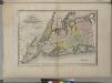
Map of the counties of New York, Queens, Kings, and Richmond.
from An atlas of the state of New York, designed for the use of engineers, containing a map of the state and of the several counties. / Projected and drawn ... under the superintendence and direction of Simeon de Witt.
A plan of New York Island, with part of Long Island, Staten Island & east New Jersey : with a particular description of the engagement on the woody heights of Long Island, between Flatbush and Brooklyn, on the 27th of August 1776 between His Majesty'
from Cartographic materials from the Emmet Collection of Manuscripts Etc. Relating to American History.
New York and vicinity [map]
1 : 24000 Geological Survey (U.S.) Geological Survey
New York City Vicinity. Pergamon World Atlas.
1 : 250000 Polish Army Topography Service
Map of New-York and its vicinity /drawn by D.H. Burr, geographer ; engraved by S. Stiles, Sherman & Smith.
from New York harbor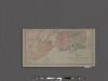
Map of New York City showing portions of Brooklyn, Jersey City, and Westchester Co.
From Manhattan
New York City and vicinity / H.M. Wilson, geographer in charge ; triangulation by U.S. Coast and Geodetic Survey ; topography by S.H. Bodfish ... [et al.]
1 : 62500 Annotatie geografische gegevens: Opname: 1887-1889, 1897 Wilson, H. M.; Bodfish, S. H.; US Coast and Geodetic Survey [Washington, D.C. : U.S. Geological Survey]
Chart and plan of the harbour of New York & the couny. adjacent, from Sandy Hook to Kingsbridge : comprehending the whole of New York and Staten Islands, and part of Long Island & the Jersey shore, and shewing the defences of New York both by land and se
from Cartographic materials from the Emmet Collection of Manuscripts Etc. Relating to American History.
Hammond's complete map of Brooklyn.
From Brooklyn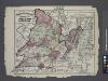
Atlas of New Jersey : Counties of Essex, Union, and Hudson.
from Combined atlas of the State of New Jersey and the County of Hudson : from actual survey, official records & private plans / by and under the direction of G. M. Hopkins ...
Chart and plan of the harbour of New York & the couny. adjacent, from Sandy Hook to Kingsbridge : comprehending the whole of New York and Staten Islands, and part of Long Island & the Jersey shore, and shewing the defences of New York both by land and se
from Whole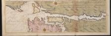
Nieuwe afteekeningh van de Noord Rivier met alle desselfs ancker plaetsen dieptens banken en klippen, geleegen in Nieuw Nederlandt [north part]
United States Gerard van Keulen
Westchester Co. & surroundings.
1 : 253440 Bien, Joseph Rudolf
Watson's guide map to summer resorts around New York.
from Whole
New York City and vicinity
1 : 62500 United States Geological Survey U.S. Geological Survey