Maps of New York
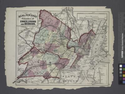
Atlas of New Jersey : Counties of Essex, Union, and Hudson.
from Combined atlas of the State of New Jersey and the County of Hudson : from actual survey, official records & private plans / by and under the direction of G. M. Hopkins ...
Map of New York City showing portions of Brooklyn, Jersey City, and Westchester Co.
From Manhattan
Linear development concept for Morrisania
From District 3
A plan of New York Island, with part of Long Island, Staten Island & east New Jersey : with a particular description of the engagement on the woody heights of Long Island, between Flatbush and Brooklyn, on the 27th of August 1776 between His Majesty'
from Cartographic materials from the Emmet Collection of Manuscripts Etc. Relating to American History.
Chart and plan of the harbour of New York & the couny. adjacent, from Sandy Hook to Kingsbridge : comprehending the whole of New York and Staten Islands, and part of Long Island & the Jersey shore, and shewing the defences of New York both by land and se
from Whole
A plan of the city of New-York & its environs : to Greenwich, on the North or Hudsons River, and to Crown Point, on the East or Sound River, shewing the several streets, publick buildings, docks, fort & battery, with the true form & course of the command
from Charts and maps
Map of Coney Island and Sheepshead Bay
From Brooklyn
Mass Transit program New York City
From The Borough
Chart and plan of the harbour of New York & the couny. adjacent, from Sandy Hook to Kingsbridge : comprehending the whole of New York and Staten Islands, and part of Long Island & the Jersey shore, and shewing the defences of New York both by land and se
from Cartographic materials from the Emmet Collection of Manuscripts Etc. Relating to American History.
Sanitation
From Environment
Mass Transit program New York City
From The Borough
New York City Vicinity. Pergamon World Atlas.
1 : 250000 Polish Army Topography Service
New York City and Environs.
1 : 30000 Walling, H. F.
Map of the Borough of Brooklyn, N. Y., and vicinity showing the street railway system controlled by the Brooklyn rapid transit system.
From Brooklyn
New York City Free Public Educational Institutions, 1911 ; prepared by the Dept. of Public Education, American Museum of Natural History.
From Manhattan
Newark
1 : 100000
New York City and vicinity
1 : 62500 United States Geological Survey U.S. Geological Survey
New York City and vicinity / H.M. Wilson, geographer in charge ; triangulation by U.S. Coast and Geodetic Survey ; topography by S.H. Bodfish ... [et al.]
1 : 62500 Annotatie geografische gegevens: Opname: 1887-1889, 1897 Wilson, H. M.; Bodfish, S. H.; US Coast and Geodetic Survey [Washington, D.C. : U.S. Geological Survey]
Passaic
1 : 125000
Passaic
1 : 125000
Passaic
1 : 125000
Passaic
1 : 125000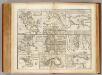
Towns, harbours, America, W.I.
Bowen, Emanuel
A plan of New York Island, with part of Long Island, Staten Island & east New Jersey : with a particular description of the engagement on the woody heights of Long Island, between Flatbush and Brooklyn, on the 27th of August 1776 between His Majesty's fo
from Whole
New York and its Environs.
1 : 253440 Rogers, Henry Darwin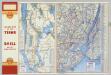
Various Regions and Cities in New Jersey, New York.
Shell Oil Company
6 Central red sandstone.
1 : 63360 Vermeule, C. C. (Cornelius Clarkson), 1858-1950
Bay and harbor of New York.
from U.S. Coast and Geodetic Survey. Nautical chart ; no. 369.
New York med Trakten Daromkring.
1 : 370000 Klinckowstrom, Axel Leonhard