Maps of New York

Maps of New York

$title$

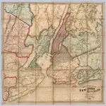
New York City and Environs.

1 : 30000 Walling, H. F.
$title$

Map of the Borough of Brooklyn, N. Y., and vicinity showing the street railway system controlled by the Brooklyn rapid transit system.

From Brooklyn
$title$

New York City Free Public Educational Institutions, 1911 ; prepared by the Dept. of Public Education, American Museum of Natural History.

From Manhattan
$title$

Educational Extension Work of the Ameriocan Museum of Natrural History. Public Schools supplied by the Museum with Nature Study Collections or Lectures in 1919.

From Manhattan
$title$

Mass Transit program New York City

From The Borough
$title$

New York City Vicinity. Pergamon World Atlas.

1 : 250000 Polish Army Topography Service
$title$

New York City and vicinity / H.M. Wilson, geographer in charge ; triangulation by U.S. Coast and Geodetic Survey ; topography by S.H. Bodfish ... [et al.]

1 : 62500 Annotatie geografische gegevens: Opname: 1887-1889, 1897 Wilson, H. M.; Bodfish, S. H.; US Coast and Geodetic Survey [Washington, D.C. : U.S. Geological Survey]
$title$

Sanitation

From Environment
$title$

New York City and vicinity

1 : 62500 United States Geological Survey U.S. Geological Survey
$title$

A plan of the city of New-York & its environs : to Greenwich, on the North or Hudsons River, and to Crown Point, on the East or Sound River, shewing the several streets, publick buildings, docks, fort & battery, with the true form & course of the command

from Charts and maps
$title$

Various Regions and Cities in New Jersey, New York.

Shell Oil Company
$title$

Hammods Atlas of New York City and the metropolitan district

$title$

Index to Sectional aerial maps of the City of New York / [photographed and assembled under the direction of the chief engineer, July 1st, 1924].

from Sectional aerial maps of the City of New York / [photographed and assembled under the direction of the chief engineer, July 1st, 1924].
$title$

Mass Transit program New York City

From The Borough
$title$

New York City and vicinity

1 : 62500 Geological Survey (U.S.) U.S.G.S.
$title$

Chart and plan of the harbour of New York & the couny. adjacent, from Sandy Hook to Kingsbridge : comprehending the whole of New York and Staten Islands, and part of Long Island & the Jersey shore, and shewing the defences of New York both by land and se

from Cartographic materials from the Emmet Collection of Manuscripts Etc. Relating to American History.
$title$

A plan of New York Island, with part of Long Island, Staten Island & east New Jersey : with a particular description of the engagement on the woody heights of Long Island, between Flatbush and Brooklyn, on the 27th of August 1776 between His Majesty's fo

from Whole
$title$

Industrial map of New York City : showing manufacturing industries, concentration, distribution, character / prepared by the Industrial Bureau of the Merchants' Association of New York.

from Whole
$title$

A plan of New York Island, with part of Long Island, Staten Island & east New Jersey : with a particular description of the engagement on the woody heights of Long Island, between Flatbush and Brooklyn, on the 27th of August 1776 between His Majesty'

from Cartographic materials from the Emmet Collection of Manuscripts Etc. Relating to American History.
$title$

Coast Chart No. 20 New York Bay And Harbor, New York.

1 : 80000 United States Coast Survey
$title$

Panorama of the Borough of the Bronx issued by the Bronx Home News.

From Bronx
$title$

New York Bay and Harbor, New York.

1 : 126720 United States Coast Survey
$title$

Map of the Borough of Manhattan and part of the Bronx showing location and extent of racial colonies.

From Manhattan
$title$

Map showing routes & stations on the dual system October, 1918

1 : 46000 New York (State). Public Service Commission State of New York Public Service Commission for the First District
$title$

Towns, harbours, America, W.I.

Bowen, Emanuel
$title$

New map of Kings and Queens counties : from actual Surveys.

From Brooklyn
$title$

Nieuwe afteekeningh van de Noord Rivier met alle desselfs ancker plaetsen dieptens banken en klippen, geleegen in Nieuw Nederlandt [north part]

United States Gerard van Keulen
$title$

Atlas of New Jersey : Counties of Essex, Union, and Hudson.

from Combined atlas of the State of New Jersey and the County of Hudson : from actual survey, official records & private plans / by and under the direction of G. M. Hopkins ...
$title$

New York Island, Part of Long Island .

1 : 100000 Marshall, John
$title$

Chart and plan of the harbour of New York & the couny. adjacent, from Sandy Hook to Kingsbridge : comprehending the whole of New York and Staten Islands, and part of Long Island & the Jersey shore, and shewing the defences of New York both by land and se

from Whole
© MapTiler © OpenStreetMap contributors
How does it work?
These instructions will show you how to find historical maps online.
Getting started
Type the place name in the search box to find the exact location. You can further adjust the search by zooming in and out.
Zoom
Zoom in and out with the buttons or use your mouse or touchpad natively.
Exact Area tool
Click here and draw a rectangle over the map to precisely define the search area.
Set filters
Narrow your search with advanced settings, such as Years (from/to), Fulltext, Publisher, etc.
Results
See the results of your search on the right side. You can scroll down to find more maps of this location.
?

Download OldMapsOnline Mobile