Maps of New York

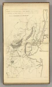
Northern Part of New Jersey, shewing the the American and British Armies after crossing the North River in 1776.
1 : 290000 Marshall, John
A plan of the northern part of New Jersey : shewing the positions of the American and British armies after crossing the North River in 1776 / drawn by S. Lewis from surveys by order of Gen. Washington ; engrav'd by Fs. Shallus.
from Revolutionary War, 1775-1783
Thirty miles round the city of New York
from Whole
40 miles around New York
1 : 158400 H.H. Lloyd & Co
Thirty miles round the city of New York
from Whole
Map of the country thirty miles round the city of New York
1 : 190080 Disturnell, John, 1801-1877 J. Disturnell
Septentrionale du New Jersey, et Positions des Armees Americaine et Britannique en 1776.
1 : 300000 Marshall, John
Map of Staten Island o Richmond County. 16 views of buildings on border. Also view of Elliottville the property of Dr. S. M. Elliott.
From Staten Island
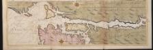
A sketch of the operations of His Majesty's fleet and army : under the command of Vice Admiral the Rt. Hble. Lord Viscount Howe and Genl. Sr. Wm. Howe, K.B., in 1776.
from Revolutionary War, 1775-1783
General map of the city of New York, consisting of boroughs of Manhattan, Brooklyn, Bronx, Queens and Richmond : consolidated into one municipality by act of the legislature of the state of New York (Chapter 378 of the laws of 1897) : showing in addit...
From Whole
Chief Engineer's Office. Board of Estimate and Apportionment. Index Map. Showing Location of the Sectional Plans of the City of New York.
from Height district map / City of New York, Board of Estimate and Apportionment.
Map ... Around The City Of New York.
1 : 205920 Colton, J. H.
Map Of The Country Thirty Miles Round the City of New York.
1 : 190080 Eddy, John H.
Map of the progress of His Majesty's armies in New York during the late campaign : illustrating the accounts publish'd in the London Gazette.
from Revolutionary War
Map of the counties of New York, Queens, Kings, and Richmond.
from An atlas of the state of New York : containing a map of the state and of the several counties / by David H. Burr.
Vingboons map of Manhattan, 1639 : a facsimile from the Library of Congress.
from Whole
Map of the Country Twenty Five Miles Round The City Of New-York.
1 : 300000 Greenleaf, Jeremiah
Map of the Country Twenty Five Miles Round The City Of New-York.
1 : 316800 Greenleaf, Jeremiah
196. New York, Washington D.C.. The World Atlas.
1 : 250000 USSR (Union of Soviet Socialist Republics).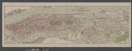
Boroughs of Manhattan and Bronx, showing the electric service of the New York Edison Co.
From Manhattan
Linear development concept for Morrisania
From District 3
United States--east coast, New York--New Jersey, New York Harbor / Coast Survey.
from New York harbor
Map of the Country Twenty Five Miles Round The City Of New-York.
1 : 211200 Burr, David H., 1803-1875
Nature's estuary: the historic tidelands of the New York New Jersey harbor estuary / cartographic design by Jennifer Cox; cartographers George Colbert and Guenter Vollath.
Jennifer Cox; George Colbert; Guenter Vollath,
Map of New York City, (Greater New York).
From Manhattan
Map of New-York and its vicinity /drawn by D.H. Burr, geographer ; engraved by S. Stiles, Sherman & Smith.
from New York harbor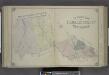
Outline Map of Passaic County, New Jersey.
from Atlas of Passaic County, New-Jersey : topographical, geological, historical, illustrated ; from actual surveys of each township and village / under the supervision of the publishers, assisted by the able engineers of Paterson.
A plan of New York Island, with part of Long Island, Staten Island & east New Jersey : with a particular description of the engagement on the woody heights of Long Island, between Flatbush and Brooklyn, on the 27th of August 1776 between His Majesty'
from Cartographic materials from the Emmet Collection of Manuscripts Etc. Relating to American History.
Chart and plan of the harbour of New York & the couny. adjacent, from Sandy Hook to Kingsbridge : comprehending the whole of New York and Staten Islands, and part of Long Island & the Jersey shore, and shewing the defences of New York both by land and se
from Cartographic materials from the Emmet Collection of Manuscripts Etc. Relating to American History.