Maps of Morris County

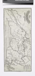
Line of the Morris Canal, New Jersey, 1827 / Desobry fecit.
from Cities and towns
Septentrionale du New Jersey, et Positions des Armees Americaine et Britannique en 1776.
1 : 300000 Marshall, John
Newark
1 : 100000
Map no. III : [to accompany A bill in the chancery of New-Jersey, at the suit of John, Earl of Stair ... against Benjamin Bond].
from A bill in the chancery of New-Jersey, at the suit of John earl of Stair, and others, proprietors of the eastern-division of New-Jersey; against Benjamin Bond. and some other persons of Elizabeth-Town, distinguished by the name of the Clinker lot right men. With three large maps, done from copper-plates. To which is added; the publications of the Council of proprietors of East New-Jersey, and Mr. Nevill's speeches to the General assembly, concerning the riots committed in New-Jersey, and the pretences of the rioters, and their seducers. These papers will give a better light into the history and constitution of New-Jersey, than any thing hitherto published, the matters whereof have been chiefly collected from records. Published by subscription: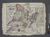
Atlas of New Jersey : Counties of Essex, Union, and Hudson.
from Combined atlas of the State of New Jersey and the County of Hudson : from actual survey, official records & private plans / by and under the direction of G. M. Hopkins ...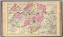
Morris Co., N.J.
1 : 126720 Beers, F. W. (Frederick W.)
Map of Coney Island and Sheepshead Bay
From Brooklyn
New Jersey, Double Page Sheet No. 7 [Map of Northeastern Red Sandstone]
From Atlas of New Jersey.
A plan of New York Island, with part of Long Island, Staten Island & east New Jersey : with a particular description of the engagement on the woody heights of Long Island, between Flatbush and Brooklyn, on the 27th of August 1776 between His Majesty'
from Cartographic materials from the Emmet Collection of Manuscripts Etc. Relating to American History.
Linear development concept for Morrisania
From District 3
New jersey
Baker, Harriet E.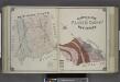
Geological Map of Passaic County, New Jersey.
from Atlas of Passaic County, New-Jersey : topographical, geological, historical, illustrated ; from actual surveys of each township and village / under the supervision of the publishers, assisted by the able engineers of Paterson.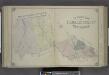
Outline Map of Passaic County, New Jersey.
from Atlas of Passaic County, New-Jersey : topographical, geological, historical, illustrated ; from actual surveys of each township and village / under the supervision of the publishers, assisted by the able engineers of Paterson.
New York City Vicinity. Pergamon World Atlas.
1 : 250000 Polish Army Topography Service
Hammods Atlas of New York City and the metropolitan district

Chart and plan of the harbour of New York & the couny. adjacent, from Sandy Hook to Kingsbridge : comprehending the whole of New York and Staten Islands, and part of Long Island & the Jersey shore, and shewing the defences of New York both by land and se
from Whole
Chart and plan of the harbour of New York & the couny. adjacent, from Sandy Hook to Kingsbridge : comprehending the whole of New York and Staten Islands, and part of Long Island & the Jersey shore, and shewing the defences of New York both by land and se
from Cartographic materials from the Emmet Collection of Manuscripts Etc. Relating to American History.
Raritan
1 : 125000
Passaic
1 : 125000
Passaic
1 : 125000
Passaic
1 : 125000
Raritan
1 : 125000
Passaic
1 : 125000
Map Of Morris County, New Jersey.
1 : 95040 Geil, S.
2 SW Highlands.
1 : 63360 Vermeule, C. C. (Cornelius Clarkson), 1858-1950
7 NE red sandstone.
1 : 63360 Vermeule, C. C. (Cornelius Clarkson), 1858-1950
6 Central red sandstone.
1 : 63360 Vermeule, C. C. (Cornelius Clarkson), 1858-1950
3 Central Highlands.
1 : 63360 Vermeule, C. C. (Cornelius Clarkson), 1858-1950
New York, Brooklyn.
1 : 42500 Beers, F. W. (Frederick W.)