Maps of Connecticut

Map of Hudson's River, with the adjacent country.
from Hudson River for D. Henry: [London],
A map of the Province of New York, with part of Pensilvania, and New England.
from Charts and maps
North America 1:1,000,000
1 : 1000000 Hudson (New York a New Jersey : řeka : oblast) United States Geological survey
A chorographical map of the Province of New-York in North America, divided into counties, manors, patents and townships, exhibiting likewise all the private grants of land made and located in that Province
1 : 322000 Sauthier, Claude Joseph Faden, William
New York (eastern section).
1 : 570000 Rand McNally and Company
A new and accurate map of the province of New York and part of the Jerseys, New England and Canada, shewing the scenes of our military operations during the present war, also the new erected state of Vermont

Map of the state of New York / by Simeon De Witt, surveyor general; engraved by G. Fairman.
from Charts and maps Simeon De Witt; G. Fairman,
Patroonships, manors and seigniories in New York recognized by the Order of Colonial Lords of Manors / Max Mayer, Thornwood, N.Y.
Max Mayer, Thornwood,
Carte de la route des lacs depuis Montréal et St. Jean jusqu'à la Riviere d'Hudson réduite d'après les meilleures cartes anglais e[s], pour servir aux Essais historiques et politiques sur la révolution de l'Amérique septentrionale
1 : 475200 Hilliard d'Auberteuil, Michel René
[Kaart], uit: Travellers' guide of the Hudson River
1 : 650000 Annotatie: Met beknopte beschrijving van de belangrijkste aan de Hudson gelegen plaatsen [S.l. : H.B. Kirkham]
An Accurate map of New York in North America, from a late survey.
from John H. Levine Collection J. (John) Hinton: [London],
"Delaware, Sullivan, Greene, Ulster, Orange, Columbia, Dutchess, and Putman Counties"
from New topographical atlas and gazetteer of New York, comprising a topographical view of the several counties of the state, ... including ... map of the United States and territories ... Compiled from the latest astronomical observations, official surveys and records of the United States and territories ...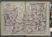
"Oneida, Madison, Otsego, Fulton, Montgomery, Schenectady, Albany, Schoharie, Warren, Saratoga, Washington, and Rensselaer Counties"
from New topographical atlas and gazetteer of New York, comprising a topographical view of the several counties of the state, ... including ... map of the United States and territories ... Compiled from the latest astronomical observations, official surveys and records of the United States and territories ...
New York.
1 : 614000 Hammond, C.S.
Plate 5: Map of New York and vicinity, accompanying Atlas of New York and vicinity.
from Atlas of New York and vicinity : from actual surveys / by and under the direction of F. W. Beers, assisted by A. B. Prindle & others
Province de New-York : en 4 feuilles / par Montrésor.
from (A-Z)
New York & vicinity.
1 : 253440 Beers, F. W. (Frederick W.)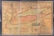
Map of Long Island with the environs of New-York and the southern part of Connecticut / compiled from various surveys & documents by J. Calvin Smith ; engraved & printed by S. Stiles & Co., N. York.
from Long Island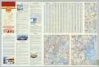
Various Regions and Cities in New England.
Shell Oil Company
A New and accurate map of the province of Pennsylvania in North America, from the best authorities.
from Whole Hinton, John,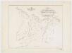
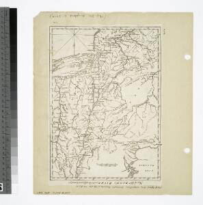
Map of the head waters of the rivers Susquehanna & Delaware embracing the early patents on the south side of the Mohawk River : from the original, drawn about the year 1790
1 : 260000 De Witt, Simeon, 1756-1834 Weed, Parsons & Co.
Map of the Southern part of the State of New York.
1 : 330000 Damerum, William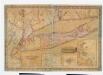
Map of Long Island with the environs of New-York and the southern part of Connecticut / compiled from various surveys & documents by J. Calvin Smith ; engraved & printed by S. Stiles & Co., N. York.
from Long Island
A plan of New York Island, with part of Long Island, Staten Island & east New Jersey : with a particular description of the engagement on the woody heights of Long Island, between Flatbush and Brooklyn, on the 27th of August 1776 between His Majesty's fo
from Whole
New York (City) & Vicinity.
1 : 400000 Asher & Adams
Massachusetts, Rhode Island, And Connecticut.
1 : 1020000 Greenleaf, Jeremiah
Massachusetts. Rhode Island. And Connecticut.
1 : 1013760 Greenleaf, Jeremiah
Connecticut and parts adjacent
1 : 375000 Covens et Mortier et Covens, junior
Province de New-York : en 4 feuilles / par Montrésor.
from (A-Z)