Maps of Connecticut
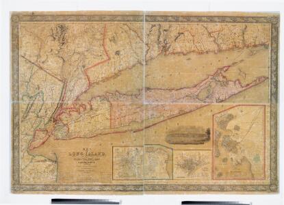
Map of Long Island with the environs of New-York and the southern part of Connecticut / compiled from various surveys & documents by J. Calvin Smith ; engraved & printed by S. Stiles & Co., N. York.
from Long Island
Putman, Rockland, Westchester, New York, Richmond, Kings, Queens, and Suffolk Counties
from New topographical atlas and gazetteer of New York, comprising a topographical view of the several counties of the state, ... including ... map of the United States and territories ... Compiled from the latest astronomical observations, official surveys and records of the United States and territories ...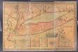
Map of Long Island with the environs of New-York and the southern part of Connecticut / compiled from various surveys & documents by J. Calvin Smith ; engraved & printed by S. Stiles & Co., N. York.
from Long Island
New York (City) & Vicinity.
1 : 400000 Asher & Adams
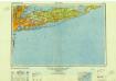
Chart of Long Island Sound, 1822 / Hooker sc.
from The American coast pilot; containing the courses and distances between the principal harbours, capes, and headlands, on the coast of North and South America; with directions for sailing into the same ... with the prevailing winds, setting of the currents, &c., and the latitudes and longitudes of the principal harbours and capes. Together with a tide table. By Edmund M. Blunt. Cor. and improved by information derived from official documents, actual observations, and the most experienced pilots.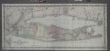
Map of Long Island and the southern part of Connecticut.
from Long Island
Plate 5: Map of New York and vicinity, accompanying Atlas of New York and vicinity.
from Atlas of New York and vicinity : from actual surveys / by and under the direction of F. W. Beers, assisted by A. B. Prindle & others
An accurate map of Staten Island : with that part of New York, Long Island and the Jerseys which is the rendesvous of the two grand armies and the supposed present seat of action / by a mercht. who resided in America 15 years.
from Whole
Connecticut and parts adjacent
1 : 375000 Covens et Mortier et Covens, junior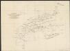
A diagram of the triangulation for the survey of the coast of the United States, made in 1817 and 1833, and the secondary triangles made in 1833 & 1834 in Connecticut & upon Long Island
1 : 412000 United States Coast Survey United States Coast Survey
A New and accurate map of the province of Pennsylvania in North America, from the best authorities.
from Whole Hinton, John,
Map of the Southern part of the State of New York.
1 : 330000 Damerum, William
A New and accurate map of the present seat of war in North America: comprehending New Jersey, Philadelphia, Pensylvania, New-York, &c.
from Revolutionary War, 1775-1783 s.n.: [London],
Connecticut with Portions of New York and Rhode Island.
1 : 610000 Colton, G.W.
Connecticut.
1 : 604000 Gray, Ormando Willis
New York.
1 : 614000 Hammond, C.S.
New York & vicinity.
1 : 253440 Beers, F. W. (Frederick W.)
Connecticut with Portions of New York & Rhode Island.
1 : 633600 Colton, G.W.
A plan of New York Island, with part of Long Island, Staten Island & east New Jersey : with a particular description of the engagement on the woody heights of Long Island, between Flatbush and Brooklyn, on the 27th of August 1776 between His Majesty's fo
from Whole
A map of the state of New Jersey: with part of the adjoining states / compiled under the patronage of the Legislature of said state by Thomas Gordon; engraved by H.S. Tanner, assisted by E.B. Dawson & W. Allen.
from Whole Thomas Gordon; Henry S. Tanner; E.B. Dawson; W. Allen,
New Jersey / engraved by A. Doolittle, Newhaven.; Carey's American pocket atlas; containing nineteen maps... with a brief description of each state.
from Carey's American pocket atlas; containing nineteen maps... with a brief description of each state. Carey, Mathew; Sweitzer, Henry,
Map of the county of Suffolk / by David H. Burr ; engd. by Rawdon Clark & Co., Albany, & Rawdon, Wright & Co., N. York.
from An atlas of the state of New York : containing a map of the state and of the several counties / by David H. Burr.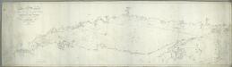
Long Island Sound from New York to Montock Point / surveyed in the years 1828, 29, & 30, by Edmund Blunt ; the writing by D.R. Harrison ; plan by W. Hooker ; W. Hooker, engraver & copper-plate printer, Franklin Hall, N.Y.
from Charts and maps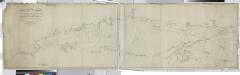
Long Island Sound from New York to Montock Point / surveyed in the years 1828, 29, & 30, by Edmund Blunt ; the writing by D.R. Harrison ; plan by W. Hooker ; W. Hooker, engraver & copper-plate printer, Franklin Hall, N.Y.
from Long Island
Brooklyn land use policy
From The Borough
Map of the county of Suffolk / by David H. Burr ; engd. by Rawdon Clark & Co., Albany, & Rawdon, Wright & Co., N. York.
from An atlas of the state of New York : containing a map of the state and of the several counties. / Projected and drawn under the superintendence and direction of Simeon de Witt ... And also the physical geography of the State ...
Map of the county of Suffolk / by David H. Burr ; engd. by Rawdon Clark & Co., Albany, & Rawdon, Wright & Co., N. York.
from An atlas of the state of New York, designed for the use of engineers, containing a map of the state and of the several counties. / Projected and drawn ... under the superintendence and direction of Simeon de Witt.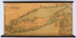
Colton's New Map Of Long Island.
1 : 126720 Colton, G.W.
Map of the country thirty three miles around the city of New York / drawn by G.W. Colton ; engraved by J.M. Atwood, N.Y.
from Whole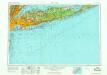
New York
1 : 250000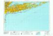
New York
1 : 250000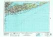
New York
1 : 250000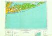
New York
1 : 250000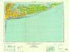
New York
1 : 250000
New York
1 : 250000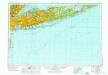
New York
1 : 250000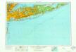
New York
1 : 250000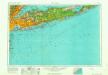
New York
1 : 250000