Maps of Connecticut

Connecticut, from the best authorities.
from Carey's general atlas, improved and enlarged : being a collection of maps of the world and quarters, their principal empires, kingdoms, &c.
Connecticut
1 : 371000 Sotzmann, D. F Bey Carl Ernst Bohn
A map of Connecticut.
from The American geography; or, A view of the present situation of the United States of America: containing astronomical geography; geographical definitions, discovery, and general description ... By Jedidiah Morse, A.M.
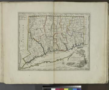
Connecticut : from the best authorities
1 : 460000 Doolittle, Amos, 1754-1832 Mathew Carey
Various Regions and Cities in New England.
Shell Oil Company
Connecticut and parts adjacent
1 : 375000 Covens et Mortier et Covens, junior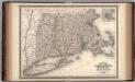
Massachusetts, Connecticut, and Rhode Island.
1 : 660000 Johnson, A.J.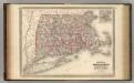
Massachusetts, Connecticut, and Rhode Island.
1 : 660000 Johnson, A.J.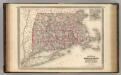
Massachusetts, Connecticut, and Rhode Island.
1 : 660000 Johnson, A.J.
Connecticut.
from The cerographic atlas of the United States. By Sidney E. Morse, A.M., and Samuel Breese, A.M.
Connecticut with Portions of New York and Rhode Island.
1 : 610000 Colton, G.W.
Connecticut.
1 : 604000 Gray, Ormando Willis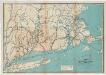
Map of the railroads of Connecticut : to accompany the report of the railroad commissioners
1 : 383000 Dodd Lithographic Co.
Massachusetts, Connecticut, Rhode Island.
1 : 688000 Finley, Anthony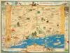
Historical map of the state of Connecticut / designed by Leon L. des Rosiers.
Leon L. des Rosiers,
Connecticut with Portions of New York & Rhode Island.
1 : 633600 Colton, G.W.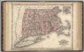
Massachusetts, Connecticut, And Rhode Island.
1 : 570240 Johnson, A.J.
Map of the Southern part of the State of New York.
1 : 330000 Damerum, William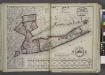
Putman, Rockland, Westchester, New York, Richmond, Kings, Queens, and Suffolk Counties
from New topographical atlas and gazetteer of New York, comprising a topographical view of the several counties of the state, ... including ... map of the United States and territories ... Compiled from the latest astronomical observations, official surveys and records of the United States and territories ...
An accurate map of Staten Island : with that part of New York, Long Island and the Jerseys which is the rendesvous of the two grand armies and the supposed present seat of action / by a mercht. who resided in America 15 years.
from Whole
Map of Massachusetts, Rhode-Island & Connecticut : compiled from the latest authorities
1 : 442000 Wilcox, A. F A.F. Wilcox & Co. ; Light & Stearns ; C. Shepard
A new and accurate map of Connecticut and Rhode Island, from the best authorities
1 : 755000 Hinton, John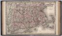
Massachusetts, Connecticut and Rhode Island.
1 : 550000 Colton, G.W.
Chart of Long Island Sound, 1822 / Hooker sc.
from The American coast pilot; containing the courses and distances between the principal harbours, capes, and headlands, on the coast of North and South America; with directions for sailing into the same ... with the prevailing winds, setting of the currents, &c., and the latitudes and longitudes of the principal harbours and capes. Together with a tide table. By Edmund M. Blunt. Cor. and improved by information derived from official documents, actual observations, and the most experienced pilots.
Map of Connecticut : from actual survey
1 : 331000 Daggett & Ely Brown & Parsons
Connecticut.
1 : 633600 Colton, G.W.
A map of the colonies of Connecticut and Rhode Island, divided into counties & townships, from the best authorities
1 : 1045440 Kitchin, Thomas Baldwin, Richard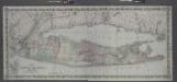
Map of Long Island and the southern part of Connecticut.
from Long Island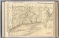
Connecticut.
1 : 336000 Rand McNally and Company