Maps of New Jersey

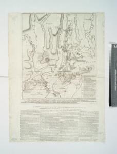
A plan of New York Island, with part of Long Island, Staten Island & east New Jersey : with a particular description of the engagement on the woody heights of Long Island, between Flatbush and Brooklyn, on the 27th of August 1776 between His Majesty's fo
from Whole
A New and accurate map of the province of Pennsylvania in North America, from the best authorities.
from Whole Hinton, John,
The Country twenty five miles round New York / drawn by a gentleman from that city ; J. Barber, sculp., Holborn Hill.
from Whole
New York-Philadelphia District.
1 : 317000 Rand McNally and Company
Plate 5: Map of New York and vicinity, accompanying Atlas of New York and vicinity.
from Atlas of New York and vicinity : from actual surveys / by and under the direction of F. W. Beers, assisted by A. B. Prindle & others
Province de New-York : en 4 feuilles / par Montrésor.
from (A-Z)
Map of the country thirty three miles around the city of New York / drawn by G.W. Colton ; engraved by J.M. Atwood, N.Y.
from Whole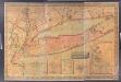
Map of Long Island with the environs of New-York and the southern part of Connecticut / compiled from various surveys & documents by J. Calvin Smith ; engraved & printed by S. Stiles & Co., N. York.
from Long Island
A New and accurate map of the present seat of war in North America: comprehending New Jersey, Philadelphia, Pensylvania, New-York, &c.
from Revolutionary War, 1775-1783 s.n.: [London],
Map no. II : [to accompany A bill in the chancery of New Jersey, at the suit of John, Earl of Stair ... against Benjamin Bond].
from A bill in the chancery of New-Jersey, at the suit of John earl of Stair, and others, proprietors of the eastern-division of New-Jersey; against Benjamin Bond. and some other persons of Elizabeth-Town, distinguished by the name of the Clinker lot right men. With three large maps, done from copper-plates. To which is added; the publications of the Council of proprietors of East New-Jersey, and Mr. Nevill's speeches to the General assembly, concerning the riots committed in New-Jersey, and the pretences of the rioters, and their seducers. These papers will give a better light into the history and constitution of New-Jersey, than any thing hitherto published, the matters whereof have been chiefly collected from records. Published by subscription:
New York & vicinity.
1 : 253440 Beers, F. W. (Frederick W.)
New Jersey.
Rand McNally and Company
New Jersey / engraved by A. Doolittle, Newhaven.; Carey's American pocket atlas; containing nineteen maps... with a brief description of each state.
from Carey's American pocket atlas; containing nineteen maps... with a brief description of each state. Carey, Mathew; Sweitzer, Henry,
New Jersey.
1 : 444000 Rand McNally and Company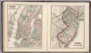
New York City. New Jersey.
1 : 749000 Gray, Ormando Willis
New Jersey.
1 : 475200 Colton, G.W.
New Jersey.
1 : 900000 Cram, George Franklin; Davis, Ellis Arthur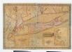
Map of Long Island with the environs of New-York and the southern part of Connecticut / compiled from various surveys & documents by J. Calvin Smith ; engraved & printed by S. Stiles & Co., N. York.
from Long Island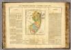
New Jersey.
1 : 980000 Buchon, J. A. C.; Carey, H. C.; Lea, I.
State of New Jersey.
1 : 600000 Winterbotham, W.
New Jersey.
1 : 500000 Colton, G.W.
New Jersey.
1 : 466000 Colton, G. Woolworth
Shell Highway Map of New Jersey.
1 : 427680 Shell Oil Company
New Jersey.
1 : 760320 Colton, J. H.
New Jersey.
1 : 596000 Hammond, C.S.
N.J. state map.
1 : 316800 Vermeule, C. C. (Cornelius Clarkson), 1858-1950
N.J. relief map.
1 : 316800 Vermeule, C. C. (Cornelius Clarkson), 1858-1950
New Jersey.
1 : 506880 Beers, F. W. (Frederick W.)
New Jersey.
1 : 545000 Rand McNally and Company