Maps of Adirondack Mountains

Province de New-York : en 4 feuilles / par Montrésor.
from (A-Z)
New York.
1 : 614000 Hammond, C.S.
Map of the New York wilderness : to accompany Wallace's Descriptive guide to the Adirondacks
1 : 253440 Ely, William Watson G. W. & C. B. Colton & Co.
Map of the Adirondack wilderness
1 : 255000 Stoddard, Seneca Ray, 1844-1917 S.R. Stoddard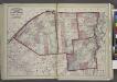
"St. Lawrence, Franklin, Clinton, and Essex"
from New topographical atlas and gazetteer of New York, comprising a topographical view of the several counties of the state, ... including ... map of the United States and territories ... Compiled from the latest astronomical observations, official surveys and records of the United States and territories ...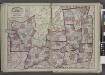
"Oneida, Madison, Otsego, Fulton, Montgomery, Schenectady, Albany, Schoharie, Warren, Saratoga, Washington, and Rensselaer Counties"
from New topographical atlas and gazetteer of New York, comprising a topographical view of the several counties of the state, ... including ... map of the United States and territories ... Compiled from the latest astronomical observations, official surveys and records of the United States and territories ...
"Herkimer, Hamilton, and Montgomery"
from New topographical atlas and gazetteer of New York, comprising a topographical view of the several counties of the state, ... including ... map of the United States and territories ... Compiled from the latest astronomical observations, official surveys and records of the United States and territories ...
State of Vermont Drawn and Engraved.
1 : 1393920 Scott, Joseph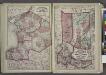
"Jefferson, Oswego, and Lewis Counties"
from New topographical atlas and gazetteer of New York, comprising a topographical view of the several counties of the state, ... including ... map of the United States and territories ... Compiled from the latest astronomical observations, official surveys and records of the United States and territories ...
An improved map of Vermont : compiled from the latest authorities
1 : 450000 Robinson, Lewis, 1793-1871 Lewis Robinson
A correct map of the State of Vermont, from actual survey : exhibiting the county and town lines, rivers, lakes, ponds, mountains, meetinghouses, mills, public roads, &c
1 : 245000 Whitelaw, James, 1748-1829 James Whitelaw
An improved map of Vermont : compiled from the latest authorities
1 : 450000 Robinson, Lewis, 1793-1871 Lewis Robinson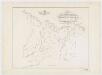
Map of the head waters of the rivers Susquehanna & Delaware embracing the early patents on the south side of the Mohawk River : from the original, drawn about the year 1790
1 : 260000 De Witt, Simeon, 1756-1834 Weed, Parsons & Co.
A correct map of the State of Vermont, from actual survey : exhibiting the county and town lines, rivers, lakes, ponds, mountains, meetinghouses, mills, public roads, &c
1 : 240000 Whitelaw, James, 1748-1829 [s.n.]
Hamilton County.
from Atlas of New York.
Vermont, from actual survey, with all the late additions & improvements
1 : 237600 Whitelaw, James Hutchinson, Ebenezer
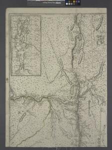
A SURVEY OF LAKE CHAMPLAIN
1 : 2700000 Brasier, William Amherst, Jeffery
(This Topographical map of the Province of Lower Canada. Sheet) E.
1 : 174240 Faden, William, 1750?-1836
Map of the county of Herkimer / by David H. Burr; engd. by Rawdon, Clark & Co., Albany, & Rawdon, Wright & Co., New York.; An atlas of the state of New York: containing a map of the state and of the several counties / by David H. Burr.
from An atlas of the state of New York : containing a map of the state and of the several counties / by David H. Burr. Burr, David H.; Rawdon, Clark & Co.; Rawdon, Wright & Co.; Stone & Clark Republishers,
Map of the county of Herkimer / by David H. Burr; engd. by Rawdon, Clark & Co., Albany, & Rawdon, Wright & Co., New York.; An atlas of the state of New York, designed for the use of engineers, containing a map of the state and of the several counties. / Projected and drawn ... under the superintendence and direction of Simeon de Witt.
from An atlas of the state of New York, designed for the use of engineers, containing a map of the state and of the several counties. / Projected and drawn ... under the superintendence and direction of Simeon de Witt. Burr, David H.; De Witt, Simeon; Rawdon, Clark & Co.; Rawdon, Wright & Co.; Stone & Clark Republishers,
Map of the county of Herkimer / by David H. Burr; engd. by Rawdon, Clark & Co., Albany, & Rawdon, Wright & Co., New York.; An atlas of the state of New York: containing a map of the state and of the several counties. / Projected and drawn under the superintendence and direction of Simeon de Witt ... And also the physical geography of the State ...
from An atlas of the state of New York : containing a map of the state and of the several counties. / Projected and drawn under the superintendence and direction of Simeon de Witt ... And also the physical geography of the State ... Burr, David H.; De Witt, Simeon,
A new and correct map, of the country in which the Army, under Lt. Gl. Burgoyne acted in 1777, shewing all the places where the principal actions happened
1 : 1267200
Outline plan of Franklin Co.
from Atlas of Franklin County, New York. : From actual surveys and official records.
Outline map of Essex County, New York.
from New topographical atlas of Essex County, New York : from official records, unpublished maps and plans, and special explorations and surveys; with a supplement comprising a map of the state of New York, and general maps of the United States and the world, with descriptions / O. W. Gray and Son.
Map of the county of Rensselaer / by David H. Burr ; engd. by Rawdon, Clark & Co., Albany, & Rawdon, Wright & Co., New York.
from An atlas of the state of New York, designed for the use of engineers, containing a map of the state and of the several counties. / Projected and drawn ... under the superintendence and direction of Simeon de Witt.
Hamilton, Herkimer counties.
1 : 158400 Bien, Joseph Rudolf
Schoharie County.
from Atlas of New York.
Map of the counties of Albany and Schenectady / by David H. Burr ; engd. by Rawdon, Clark & Co., Albany, & Rawdon, Wright & Co., N.Y.
from An atlas of the state of New York, designed for the use of engineers, containing a map of the state and of the several counties. / Projected and drawn ... under the superintendence and direction of Simeon de Witt.
Map of the county of Saratoga / by David H. Burr ; engd. by Rawdon, Clark & Co., Albany, & Rawdon, Wright & Co., N. York.
from An atlas of the state of New York, designed for the use of engineers, containing a map of the state and of the several counties. / Projected and drawn ... under the superintendence and direction of Simeon de Witt.