Maps of Fairfield County

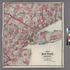
Plate 5: Map of New York and vicinity, accompanying Atlas of New York and vicinity.
from Atlas of New York and vicinity : from actual surveys / by and under the direction of F. W. Beers, assisted by A. B. Prindle & others
A New and accurate map of the province of Pennsylvania in North America, from the best authorities.
from Whole Hinton, John,
New York & vicinity.
1 : 253440 Beers, F. W. (Frederick W.)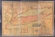
Map of Long Island with the environs of New-York and the southern part of Connecticut / compiled from various surveys & documents by J. Calvin Smith ; engraved & printed by S. Stiles & Co., N. York.
from Long Island
Putman, Rockland, Westchester, New York, Richmond, Kings, Queens, and Suffolk Counties
from New topographical atlas and gazetteer of New York, comprising a topographical view of the several counties of the state, ... including ... map of the United States and territories ... Compiled from the latest astronomical observations, official surveys and records of the United States and territories ...
Map of Long Island with the environs of New-York and the southern part of Connecticut / compiled from various surveys & documents by J. Calvin Smith ; engraved & printed by S. Stiles & Co., N. York.
from Long Island
A plan of New York Island, with part of Long Island, Staten Island & east New Jersey : with a particular description of the engagement on the woody heights of Long Island, between Flatbush and Brooklyn, on the 27th of August 1776 between His Majesty's fo
from Whole
New York.
1 : 614000 Hammond, C.S.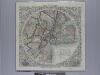
Map of the country thirty three miles around the city of New York / drawn by G.W. Colton ; engraved by J.M. Atwood, N.Y.
from Whole
Map no. II : [to accompany A bill in the chancery of New Jersey, at the suit of John, Earl of Stair ... against Benjamin Bond].
from A bill in the chancery of New-Jersey, at the suit of John earl of Stair, and others, proprietors of the eastern-division of New-Jersey; against Benjamin Bond. and some other persons of Elizabeth-Town, distinguished by the name of the Clinker lot right men. With three large maps, done from copper-plates. To which is added; the publications of the Council of proprietors of East New-Jersey, and Mr. Nevill's speeches to the General assembly, concerning the riots committed in New-Jersey, and the pretences of the rioters, and their seducers. These papers will give a better light into the history and constitution of New-Jersey, than any thing hitherto published, the matters whereof have been chiefly collected from records. Published by subscription: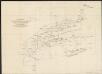
A diagram of the triangulation for the survey of the coast of the United States, made in 1817 and 1833, and the secondary triangles made in 1833 & 1834 in Connecticut & upon Long Island
1 : 412000 United States Coast Survey United States Coast Survey
New York (City) & Vicinity.
1 : 400000 Asher & Adams
Province de New-York : en 4 feuilles / par Montrésor.
from (A-Z)
An accurate map of Staten Island : with that part of New York, Long Island and the Jerseys which is the rendesvous of the two grand armies and the supposed present seat of action / by a mercht. who resided in America 15 years.
from Whole
A New and accurate map of the present seat of war in North America: comprehending New Jersey, Philadelphia, Pensylvania, New-York, &c.
from Revolutionary War, 1775-1783 s.n.: [London],
Map of the Southern part of the State of New York.
1 : 330000 Damerum, William
Connecticut and parts adjacent
1 : 375000 Covens et Mortier et Covens, junior
New Jersey / engraved by A. Doolittle, Newhaven.; Carey's American pocket atlas; containing nineteen maps... with a brief description of each state.
from Carey's American pocket atlas; containing nineteen maps... with a brief description of each state. Carey, Mathew; Sweitzer, Henry,
Thirty three miles around the city of New-York
from Whole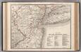
New York-Philadelphia District.
1 : 317000 Rand McNally and Company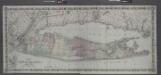
Map of Long Island and the southern part of Connecticut.
from Long Island
Thirty miles round the city of New York
from Whole
Brooklyn land use policy
From The Borough
40 miles around New York
1 : 158400 H.H. Lloyd & Co
Map of Long Island with the environs of New-York and the southern part of Connecticut / compiled from various surveys & documents by J. Calvin Smith ; engraved & printed by S. Stiles & Co., N. York.
From Long Island
Connecticut with Portions of New York and Rhode Island.
1 : 610000 Colton, G.W.
Map of the counties of New York, Queens, Kings, and Richmond.
from An atlas of the state of New York : containing a map of the state and of the several counties. / Projected and drawn under the superintendence and direction of Simeon de Witt ... And also the physical geography of the State ...
Westchester, Plate No. 1 [Map of Westchester County and Surroundings] / prepared under the direction of Joseph R. Bien, from general surveys and official records.
From Atlas of Westchester County, New York
Connecticut.
1 : 604000 Gray, Ormando Willis