Maps of New York
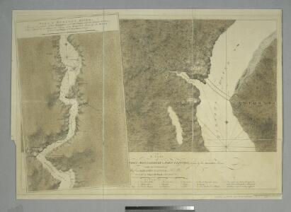
A plan of Fort Montgomery & Fort Clinton, taken by His Majesty's forces, under the command of Maj. Genl. Sir Henry Clinton, K.B. / survey'd by Major Holland, Survr. Genl. &c.
from Cartographic materials from the Emmet Collection of Manuscripts Etc. Relating to American History.
Delaware / engraved by A. Doolittle, Newhaven.; Carey's American pocket atlas; containing nineteen maps... with a brief description of each state.
from Carey's American pocket atlas; containing nineteen maps... with a brief description of each state. Carey, Mathew; Sweitzer, Henry,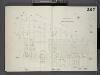
Brooklyn, V. 9, Double Page Plate No. 267 [Map bounded by Covert Ave., Bleecker St., Irving Ave., Flushing Ave.]
From Atlas 89. Vol. 9, 1888.
New York med Trakten Daromkring.
1 : 370000 Klinckowstrom, Axel Leonhard
Nieuwe afteekeningh van de Noord Rivier met alle desselfs ancker plaetsen dieptens banken en klippen, geleegen in Nieuw Nederlandt [north part]
United States Gerard van Keulen
Chart of the entrance of Hudson's River, from Sandy Hook to New York : with the banks, depths of water, sailing-marks, & ca
1 : 70000 Printed for Robt. Sayer & John Bennett, sea chart & map-sellers ...
The Hudson by daylight map : showing the prominent residences, historic landmarks, old reaches of the Hudson, Indian names, &c.
from Hudson River
Bay and harbor of New York.
from U.S. Coast and Geodetic Survey. Nautical chart ; no. 369.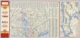
(Metropolitan New York and Long Island) Northern Section. To and Through Manhattan.
Shell Oil Company
7 NE red sandstone.
1 : 63360 Vermeule, C. C. (Cornelius Clarkson), 1858-1950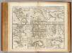
Towns, harbours, America, W.I.
Bowen, Emanuel
Facsimile of the unpublished British head quarters coloured manuscript map of New York & environs / reproduced from the original drawing in the War Office, London.
from Whole
Map of the Hudson ... from New York Harbor the Fort Washington.
from Map of the Hudson between Sandy Hook & Sandy Hill : with the post road between New York and Albany / Bridges delt. ; Rollinson sct.
The Hudson by daylight map, from New York Bay to the head of tide water : containing names of streams, islands, and heights of mountains according to the latest coast survey : also the names of prominent residences, historic land marks, the old reaches o
from Hudson River
Chart and plan of the harbour of New York & the couny. adjacent, from Sandy Hook to Kingsbridge : comprehending the whole of New York and Staten Islands, and part of Long Island & the Jersey shore, and shewing the defences of New York both by land and se
from Cartographic materials from the Emmet Collection of Manuscripts Etc. Relating to American History.
Map of the Hudson ... from Sandy Hook to New York Harbor
from Map of the Hudson between Sandy Hook & Sandy Hill : with the post road between New York and Albany / Bridges delt. ; Rollinson sct.
Map of Coney Island and Sheepshead Bay.
From Brooklyn
Tibbits Brook route.
from Croton Water System
Map of Staten Island , Richmond County, Staten Island,New York.
from Atlas of Staten Island, Richmond County, New York, from official records and surveys; compiled and drawn by F. W. Beers.
A plan of New York Island, with part of Long Island, Staten Island & east New Jersey : with a particular description of the engagement on the woody heights of Long Island, between Flatbush and Brooklyn, on the 27th of August 1776 between His Majesty's fo
from Whole
New York and its Environs.
1 : 253440 Rogers, Henry Darwin
Manhattan land use policy
From The Borough
Manhattan Topography
From The Borough
New Jersey, Double Page Sheet No. 7 [Map of Northeastern Red Sandstone]
From Atlas of New Jersey.
Map of the Hudson ... from Tarrytown to Dunderbergh.
from Map of the Hudson between Sandy Hook & Sandy Hill : with the post road between New York and Albany / Bridges delt. ; Rollinson sct.
Chart and plan of the harbour of New York & the couny. adjacent, from Sandy Hook to Kingsbridge : comprehending the whole of New York and Staten Islands, and part of Long Island & the Jersey shore, and shewing the defences of New York both by land and se
from Whole
New York City Vicinity. Pergamon World Atlas.
1 : 250000 Polish Army Topography Service
9 Monmouth shore.
1 : 63360 Vermeule, C. C. (Cornelius Clarkson), 1858-1950
Map of New-York Bay And Harbor And The Environs.
1 : 30600 United States Coast Survey