Maps of New York

Map of the Hudson ... from Tarrytown to Dunderbergh.
from Map of the Hudson between Sandy Hook & Sandy Hill : with the post road between New York and Albany / Bridges delt. ; Rollinson sct.
N.Y., Kings, Queens, Richmond, Rockland, Westchester, Putnam counties.
1 : 158400 Bien, Joseph Rudolf
196. New York, Washington D.C.. The World Atlas.
1 : 250000 USSR (Union of Soviet Socialist Republics).
Map of Coney Island and Sheepshead Bay.
From Brooklyn
Westchester Co. & surroundings.
1 : 253440 Bien, Joseph Rudolf
[Rockland County].
from Atlas of New York.
Map of the county of Westchester / by David H. Burr ; engd. by Rawdon, Clark & Co., Albany, & Rawdon, Wright & Co., New York.
from An atlas of the state of New York : containing a map of the state and of the several counties. / Projected and drawn under the superintendence and direction of Simeon de Witt ... And also the physical geography of the State ...
New York City Vicinity. Pergamon World Atlas.
1 : 250000 Polish Army Topography Service
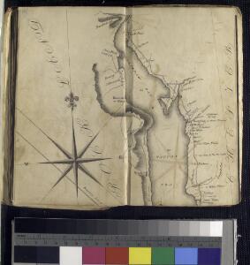
Cortlandt Manor map : prepared expressly for this work / copied for Piere Van Cortlandt esqr., June 1774, by G. Baneker.
from Cities and towns, A-Z
Map of New York City, (Greater New York).
From Manhattan
A plan of the operations of the King's army under the command of General Sr. William Howe, K.B. in New York and east New Jersey against the American forces commanded by General Washington from the 12th. of October, to the 28th. of November 1776 ...
1 : 88000 Sauthier, Claude Joseph Stedman, Charles
Hammods Atlas of New York City and the metropolitan district

Index to Sectional aerial maps of the City of New York / [photographed and assembled under the direction of the chief engineer, July 1st, 1924].
from Sectional aerial maps of the City of New York / [photographed and assembled under the direction of the chief engineer, July 1st, 1924].
The Hudson by daylight map, from New York Bay to the head of tide water : containing names of streams, islands, and heights of mountains according to the latest coast survey : also the names of prominent residences, historic land marks, the old reaches o
from Hudson River
Mass Transit program New York City
From The Borough
Sanitation
From Environment
New York City and Environs.
1 : 30000 Walling, H. F.
Linear development concept for Morrisania
From District 3
A plan of the city of New-York & its environs : to Greenwich, on the North or Hudsons River, and to Crown Point, on the East or Sound River, shewing the several streets, publick buildings, docks, fort & battery, with the true form & course of the command
from Charts and maps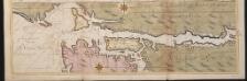
Nieuwe afteekeningh van de Noord Rivier met alle desselfs ancker plaetsen dieptens banken en klippen, geleegen in Nieuw Nederlandt [north part]
United States Gerard van Keulen
Mass Transit program New York City
From The Borough
New Jersey, Double Page Sheet No. 7 [Map of Northeastern Red Sandstone]
From Atlas of New Jersey.
Panorama of the Borough of the Bronx issued by the Bronx Home News.
From Bronx
A plan of New York Island, with part of Long Island, Staten Island & east New Jersey : with a particular description of the engagement on the woody heights of Long Island, between Flatbush and Brooklyn, on the 27th of August 1776 between His Majesty'
from Cartographic materials from the Emmet Collection of Manuscripts Etc. Relating to American History.
New York Island, Part of Long Island .
1 : 100000 Marshall, John
New York City Free Public Educational Institutions, 1911 ; prepared by the Dept. of Public Education, American Museum of Natural History.
From Manhattan
Map of the Borough of Brooklyn, N. Y., and vicinity showing the street railway system controlled by the Brooklyn rapid transit system.
From Brooklyn
Industrial map of New York City : showing manufacturing industries, concentration, distribution, character / prepared by the Industrial Bureau of the Merchants' Association of New York.
from Whole
Educational Extension Work of the Ameriocan Museum of Natrural History. Public Schools supplied by the Museum with Nature Study Collections or Lectures in 1919.
From Manhattan