Maps of Hudson County

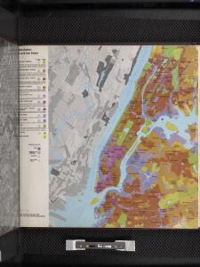
Manhattan land use policy
From The Borough
Westchester, Double Page Plate No. 2 [Map of City and County of new York] / prepared under the direction of Joseph R. Bien, from general surveys and official records.
From Atlas of Westchester County, New York
Manhattan Topography
From The Borough
Manhattan public and publicly aided housing
From The Borough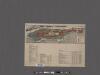
Map of the Borough of Manhattan and part of the Bronx showing location and extent of racial colonies.
From Manhattan
A plan of New York Island, with part of Long Island, Staten Island & east New Jersey : with a particular description of the engagement on the woody heights of Long Island, between Flatbush and Brooklyn, on the 27th of August 1776 between His Majesty's fo
from Whole
Map of the Hudson ... from New York Harbor the Fort Washington.
from Map of the Hudson between Sandy Hook & Sandy Hill : with the post road between New York and Albany / Bridges delt. ; Rollinson sct.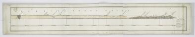
Tibbits Brook route.
from Croton Water System
TheRand McNally map of the Borough of Manhattan, the principal portion of the Boroughs of Bronx, Brooklyn, and Queens and the business district of Jersey City.
From Manhattan
Map of New York City showing portions of Brooklyn, Jersey City, and Westchester Co.
From Manhattan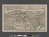
TheHeart of Greater New York, showing commercial facilities and tentative plans of development and recent additions.
From Manhattan
Map of part of New York City, showing underground mains of the Edison Electric Illuminating Co. of New York.
From Manhattan
New Guide Map of Manhattan and The Bronx.
From Manhattan
Ile de New York et Positions des Armees Americaine et Britannique, 27 Aout 1776.
1 : 100000 Marshall, John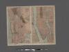
TheHome Life Publishing Co.' s map of the City of New York.
From Manhattan
Manhattan Borough and part of Bronx Borough of the City of New York.
From Manhattan
Colton's Map of the City of New York, prepared for the Department of Street Cleaning.
From Manhattan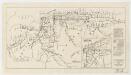
Map showing routes & stations on the dual system October, 1918
1 : 46000 New York (State). Public Service Commission State of New York Public Service Commission for the First District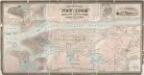
City & county map of New-York, Brooklyn, Williamsburgh, Jersey City & the adjacent waters / by J.H. Colton, N.Y. ; engraved by D.G. Johnson, N. York.
from Manhattan
Map of the five cities of New York, Brooklyn, Jersey City, Hoboken & Hudson City : Northern sheet
Dripps, M. (Matthew) Common Council
Map of the five cities of New York, Brooklyn, Jersey City, Hoboken & Hudson City : Southern sheet
Dripps, M. (Matthew) Common Council
Map of New York City : showing passenger and freight lines, ticket and freight offices, subway, elevated, and street car lines.
From Manhattan
TheRand McNally map of the Borough of Manhattan.
From Manhattan
TheRand McNally map of the Borough of Manhattan.
From Manhattan
Map of New York City showing portions of Brooklyn, Jersey City, and Westchester Co. on enlarged scale.
From Manhattan
New York City.
1 : 43000 Rand McNally and Company
BLOCK INDEX. Includes the map of Manhattan, Sections 1-8.
from Atlas of the city of New York, Manhattan Island. From actual surveys and official plans / by George W. and Walter S. Bromley.
Outline Map of Large Scale Real Estate Atlases of New York City, Borough of Manhattan.
from Atlas of the city of New York, borough of Manhattan. From actual surveys and official plans / by George W. and Walter S. Bromley.
Outline map of large scale real estate atlases of New York City, Borough of Manhattan.
from Atlas of the city of New York, borough of Manhattan / from actual surveys and official plans by George W. and Walter S. Bromley.