Maps of Bergen County

7 NE red sandstone.
1 : 63360 Vermeule, C. C. (Cornelius Clarkson), 1858-1950
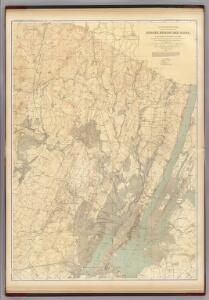
New Jersey, Double Page Sheet No. 7 [Map of Northeastern Red Sandstone]
From Atlas of New Jersey.
Watson's new map of the city of Brooklyn including Brooklyn
From Brooklyn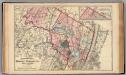
Bergen, Passaic Cos., N.J.
1 : 126720 Beers, F. W. (Frederick W.)
Map of Coney Island and Sheepshead Bay
From Brooklyn
A plan of New York Island, with part of Long Island, Staten Island & east New Jersey : with a particular description of the engagement on the woody heights of Long Island, between Flatbush and Brooklyn, on the 27th of August 1776 between His Majesty's fo
from Whole
Paterson, N.J. - N.Y., ed. of Feb. 1903, repr. 1924
from New Jersey, 15 minute series (topographic) / mapped, edited, and published by the Geological Survey.
Westchester, Double Page Plate No. 2 [Map of City and County of new York] / prepared under the direction of Joseph R. Bien, from general surveys and official records.
From Atlas of Westchester County, New York
General map of the city of New York, consisting of boroughs of Manhattan, Brooklyn, Bronx, Queens and Richmond : consolidated into one municipality by act of the legislature of the state of New York (Chapter 378 of the laws of 1897) : showing in addition
from Whole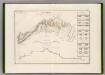
Canal Morris.
1 : 250000 Poussin, Guillaume Tell, 1794-1876
Manhattan Topography
From The Borough
Facsimile of the unpublished British head quarters coloured manuscript map of New York & environs / reproduced from the original drawing in the War Office, London.
from Whole
Manhattan land use policy
From The Borough
Map of the Hudson ... from New York Harbor the Fort Washington.
from Map of the Hudson between Sandy Hook & Sandy Hill : with the post road between New York and Albany / Bridges delt. ; Rollinson sct.
The Hudson by daylight map : showing the prominent residences, historic landmarks, old reaches of the Hudson, Indian names, &c.
from Hudson River
Manhattan public and publicly aided housing
From The Borough
Paterson
1 : 62500
Paterson
1 : 62500
Paterson
1 : 62500
Paterson
1 : 62500
Paterson
1 : 62500
Paterson
1 : 62500
Paterson
1 : 62500
Paterson
1 : 62500
Paterson
1 : 62500
Paterson
1 : 62500
Paterson
1 : 62500
TheHome Life Publishing Co.' s map of the City of New York.
From Manhattan
Tibbits Brook route.
from Croton Water System