Maps of Monmouth County

9 Monmouth shore.
1 : 63360 Vermeule, C. C. (Cornelius Clarkson), 1858-1950
Hammods Atlas of New York City and the metropolitan district

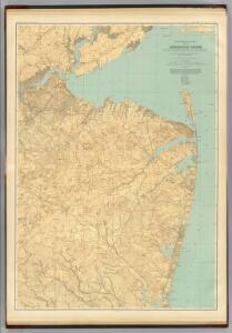
Navesink
1 : 125000
Navesink
1 : 125000
Navesink
1 : 125000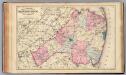
Monmouth Co., N.J.
1 : 126720 Beers, F. W. (Frederick W.)
General map of the city of New York, consisting of boroughs of Manhattan, Brooklyn, Bronx, Queens and Richmond : consolidated into one municipality by act of the legislature of the state of New York (Chapter 378 of the laws of 1897) : showing in addition
from Whole
Sandy Hook
1 : 62500
Sandy Hook
1 : 62500
Sandy Hook
1 : 62500
Sandy Hook
1 : 62500
Sandy Hook
1 : 62500
Sandy Hook
1 : 62500
Sandy Hook
1 : 62500
Sandy Hook
1 : 62500
Sandy Hook
1 : 62500
The harbour of New York, Entrance to Chesapeake Bay, coastal views.
1 : 900000 Blunt, Edmund M. (Edmund March), 1770-1862
(Coast section no. 1. Sandy Hook to Shark River)
1 : 63360 Woolman, H. C.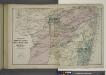
Portions of Middletown, Shrewsbury and Ocean Townships. [Townships]
from Atlas of Monmouth co., New Jersey. From recent and actual surveys and records, under the superintendence of F.W. Beers.
Marlboro Business Notices. ; Marlboro [Township]
from Atlas of Monmouth co., New Jersey. From recent and actual surveys and records, under the superintendence of F.W. Beers.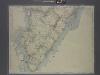
New map of Staten Island
from Staten Island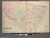
Monmouth County, Double Page Plate No. 30 [Map of Middle Township]
From Wolverton's atlas of Monmouth County, New Jersey : compiled from actual surveys, state and county official records and private plans.
Freehold [Township]; Freehold Business Notices.
from Atlas of Monmouth co., New Jersey. From recent and actual surveys and records, under the superintendence of F.W. Beers.
Long Branch
1 : 24000
Long Branch
1 : 24000
Long Branch
1 : 24000
Long Branch
1 : 24000
Long Branch
1 : 24000
Sandy Hook
1 : 24000
Sandy Hook
1 : 24000
Sandy Hook
1 : 24000
Sandy Hook
1 : 24000
Sandy Hook
1 : 24000