Maps of Richmond County
New map of Staten Island
from Staten Island
Map of New-York Bay and Harbor and the environs / founded upon a trigonometrical survey under the direction of F. R. Hassler, superintendent of the Survey of the Coast of the United States ; triangulation by James Ferguson and Edmund Blunt, assistants ;
from New York harbor
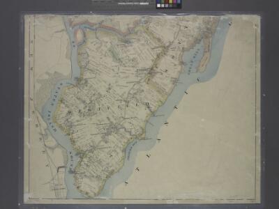
Richmond Co., Staten Island.
1 : 31680 Vermeule, C. C. (Cornelius Clarkson), 1858-1950
Staten Island South.
1 : 253440 Dripps, Matthew
Arthur Kill
1 : 24000
Arthur Kill
1 : 24000
Arthur Kill
1 : 24000
Arthur Kill
1 : 24000
Arthur Kill
1 : 24000
Arthur Kill
1 : 24000
Arthur Kill
1 : 24000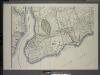
General map of the borough of Richmond (Staten Island) in the city of New York : showing in addition to the existing topographical features of the borough a tentative and preliminary plan for a street system of the same.
from Staten Island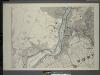
General map of the borough of Richmond (Staten Island) in the city of New York : showing in addition to the existing topographical features of the borough a tentative and preliminary plan for a street system of the same.
from Staten Island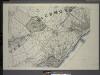
General map of the borough of Richmond (Staten Island) in the city of New York : showing in addition to the existing topographical features of the borough a tentative and preliminary plan for a street system of the same.
from Staten Island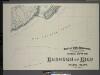
General map of the borough of Richmond (Staten Island) in the city of New York : showing in addition to the existing topographical features of the borough a tentative and preliminary plan for a street system of the same.
from Staten Island
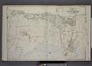
Area District Map Section No. 35
from Area district map / City of New York, Board of Estimate and Apportionment.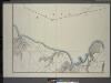
General map of the borough of Richmond (Staten Island) in the city of New York : showing in addition to the existing topographical features of the borough a tentative and preliminary plan for a street system of the same.
from Staten Island
Height District Map Section No. 33
from Height district map / City of New York, Board of Estimate and Apportionment.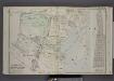
Part of Wards 4 & 5. [Map bound by Clarke Ave, Emmet Ave, Maple Ave, Lower Bay, Seaside Ave, Bridge Ave, Fresh Hills Road; Property of South New York Villa Site Co. - 1st St, Cortel You Ave, Fresh Kill Road, Richmond Ave, 21st St, Thompson Ave
from Atlas of the borough of Richmond, city of New York.
Use District Map Section No. 35
from Use district map / City of New York, Board of Estimate and Apportionment.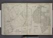
Part of Ward 5. [Map bound by Huguenot Ave, Fresh Kills Road, Bridge Ave, Staten Island Rapid Transit, Amboy Road, Foster or Rossville Ave, Wood Row Road; Sub Plan A - Annadale Road, Moffatt St, Washington Ave; Richmond ( Part of Wards 3 & 4
from Atlas of the borough of Richmond, city of New York.
Height District Map Section No. 32
from Height district map / City of New York, Board of Estimate and Apportionment.
Height District Map Section No. 35; Height district map / City of New York, Board of Estimate and Apportionment.
from Height district map / City of New York, Board of Estimate and Apportionment. New York (N.Y.). Board of Estimate and Apportionment,
Area District Map Section No. 32; Area district map / City of New York, Board of Estimate and Apportionment.
from Area district map / City of New York, Board of Estimate and Apportionment. New York (N.Y.). Board of Estimate and Apportionment,
Use District Map Section No. 32; Use district map / City of New York, Board of Estimate and Apportionment.
from Use district map / City of New York, Board of Estimate and Apportionment. New York (N.Y.). Board of Estimate and Apportionment,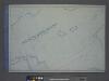
Use District Map Section No. 33; Use district map / City of New York, Board of Estimate and Apportionment.
from Use district map / City of New York, Board of Estimate and Apportionment. New York (N.Y.). Board of Estimate and Apportionment,
Area District Map Section No. 33; Area district map / City of New York, Board of Estimate and Apportionment.
from Area district map / City of New York, Board of Estimate and Apportionment. New York (N.Y.). Board of Estimate and Apportionment,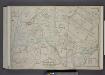
Part of Wards 3, 4, & 5. [Map bound by Cannon Ave, Burying Hill Road, Richmond Turnpike, Union Ave, Old Stone Road, Rockland Ave, Forest Hill Road, Fresh Kills Road, State Line; Lots at Linoleumville - Richmond Turnpike, Feldmeyer Lane]
from Atlas of the borough of Richmond, city of New York.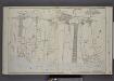
Part of Wards 4 & 5. [Map bound by The Staten Island Railway Co., Seaside Ave, Southfield Boulevard, Bulkhead Line, Shore Road, Sycamore Ave, Androvette Ave, Amboy Road]
from Atlas of the borough of Richmond, city of New York.