Maps of Richmond County
General map of the city of New York, consisting of boroughs of Manhattan, Brooklyn, Bronx, Queens and Richmond : consolidated into one municipality by act of the legislature of the state of New York (Chapter 378 of the laws of 1897) : showing in addition
from Whole
New map of Staten Island
from Staten Island
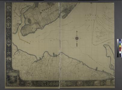
Map of New-York Bay and Harbor and the environs / founded upon a trigonometrical survey under the direction of F. R. Hassler, superintendent of the Survey of the Coast of the United States ; triangulation by James Ferguson and Edmund Blunt, assistants ;
from New York harbor
Sandy Hook
1 : 24000
Sandy Hook
1 : 24000
Sandy Hook
1 : 24000
Sandy Hook
1 : 24000
Sandy Hook
1 : 24000
Sandy Hook
1 : 24000
Keyport
1 : 24000
Keyport
1 : 24000
Keyport
1 : 24000
Keyport
1 : 24000
Keyport
1 : 24000
Keyport
1 : 24000
South Amboy
1 : 24000
South Amboy
1 : 24000
South Amboy
1 : 24000
South Amboy
1 : 24000
South Amboy
1 : 24000
South Amboy
1 : 25000
South Amboy
1 : 31680
South Amboy
1 : 31680
South Amboy
1 : 31680
South Amboy
1 : 31680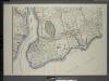
General map of the borough of Richmond (Staten Island) in the city of New York : showing in addition to the existing topographical features of the borough a tentative and preliminary plan for a street system of the same.
from Staten Island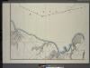
General map of the borough of Richmond (Staten Island) in the city of New York : showing in addition to the existing topographical features of the borough a tentative and preliminary plan for a street system of the same.
from Staten Island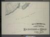
General map of the borough of Richmond (Staten Island) in the city of New York : showing in addition to the existing topographical features of the borough a tentative and preliminary plan for a street system of the same.
from Staten Island
Height District Map Section No. 34
from Height district map / City of New York, Board of Estimate and Apportionment.