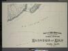
Maps of Richmond County
Height District Map Section No. 34
from Height district map / City of New York, Board of Estimate and Apportionment.
Use District Map Section No. 34; Use district map / City of New York, Board of Estimate and Apportionment.
from Use district map / City of New York, Board of Estimate and Apportionment. New York (N.Y.). Board of Estimate and Apportionment,
Area District Map Section No. 34; Area district map / City of New York, Board of Estimate and Apportionment.
from Area district map / City of New York, Board of Estimate and Apportionment. New York (N.Y.). Board of Estimate and Apportionment,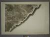
34A - N.Y. City (Aerial Set).
from Sectional aerial maps of the City of New York / [photographed and assembled under the direction of the chief engineer, July 1st, 1924].
34C - N.Y. City (Aerial Set).
from Sectional aerial maps of the City of New York / [photographed and assembled under the direction of the chief engineer, July 1st, 1924].
Nelson Ave, Cleveland Ave, 2nd St, Madison TER, Great Kills RD, South Side Boulevard, Cole PL, Cole CT, Lockmans Creek, Grattan Ave, 13th St, 12th St, Emmett Ave, Brook Ave, Flat Creek, Mill Pond Creek, Lower New York Bay, Oyster Island, Crookes Po
from Atlas of the city of New York, borough of Richmond, Staten Island. From actual surveys and original plans, by George W. and Walter S. Bromley.
Section 26
from Atlas of Staten Island, Richmond County, New York, from official records and surveys; compiled and drawn by F. W. Beers.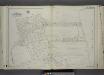
Part of Ward 4. [Map bound by Oak Ave, Mill Road, Kissam Ave, Lower New York Bay, Brook Ave, Mill Pond, South Side Boulevard]
from Atlas of the city of New York, borough of Richmond, Staten Island. From actual surveys and original plans, by George W. and Walter S. Bromley.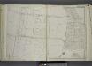
Part of Ward 4. [Map bound by Amboy Road, Cedarview Ave, Oak Ave, South Side Boulevard, 9th St, 14th St, Baldwin Ave (Jefferson Ave), Cole CT, Cole Place, Bay Terrace]
from Atlas of the city of New York, borough of Richmond, Staten Island. From actual surveys and original plans, by George W. and Walter S. Bromley.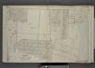
Part of Ward 4. [Map bound by New Dorp Lane, New Dorp Beach, Lower Bay, Birch Ave, Brook Ave, Amboy Road, Richmond Road]
from Atlas of the borough of Richmond, city of New York.
Part of Ward 4. [Map bound by New Dorp Lane, New Dorp Beach, Lower New York Bay, Old Mill Road (Coles Ave), Tysens Lane, South Side Boulevard]
from Atlas of the city of New York, borough of Richmond, Staten Island. From actual surveys and original plans, by George W. and Walter S. Bromley.
Part of Southfield.
from Atlas of Staten Island, Richmond County, New York, from official records and surveys; compiled and drawn by F. W. Beers.
Part of Westfield & Southfield.
from Atlas of Staten Island, Richmond County, New York, from official records and surveys; compiled and drawn by F. W. Beers.
Borough of Richmond, Topographical Survey.
from Borough of Richmond, Topographical Survey.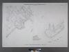
Sheet No. 86. [Includes Southside Boulevard, Guyon Avenue, Crescent Avenue, Nelson Avenue and Wiman Avenue in Crescent Beach, and Crookes Point.]; Borough of Richmond, Topographical Survey.
from Borough of Richmond, Topographical Survey. Staten Island. Topographical Bureau.,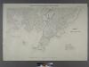
Sheet Nos. 79 & 80. [Include Oyster Island, Lockman's Creek, Flat Creek and Mill Creek Estuaries.]; Borough of Richmond, Topographical Survey.
from Borough of Richmond, Topographical Survey. Staten Island. Topographical Bureau.,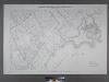
Sheet No. 78. [Includes Great Kills, Amboy Road, Midland Road, Great Kills Road, Highland Avenue, Southside Boulevard, Nelson Avenue, Duck Creek.]; Borough of Richmond, Topographical Survey.
from Borough of Richmond, Topographical Survey. Staten Island. Topographical Bureau.,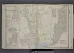
Part of Wards 4 & 5. [Map bound by Railroad Ave, The Staten Island Railway Co., Great Kills Road, Amboy Road, Southfield Boulevard, St, Mansion Ave, Cleveland Ave, Nelson Ave, Lindenwood Road, Park Terrace, Seeley Lane, Colon Ave; Sub Plan -
from Atlas of the borough of Richmond, city of New York.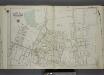
Part of Wards 4 & 5. [Map bound by Ocean View Cemetery, Staten Island Rail Road, Amboy Road, Keegans Lane, South Side Boulevard, Great Kills Road, Great Kills, Madison Ave, Martha PL (1st St), Cleveland Ave, 3rd St, Nelson Ave,
from Atlas of the city of New York, borough of Richmond, Staten Island. From actual surveys and original plans, by George W. and Walter S. Bromley.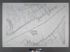
Sheet Nos. 92 & 96. [Sheet No. 92.Includes (Annadale) Woods of Arden Road and Southside Boulevard. - Sheet No. 96. Includes Huguenot Avenue, and Terra Marine Inn.]; Borough of Richmond, Topographical Survey.
from Borough of Richmond, Topographical Survey. Staten Island. Topographical Bureau.,
The Narrows
1 : 24000
The Narrows
1 : 24000
The Narrows
1 : 24000
The Narrows
1 : 24000
The Narrows
1 : 24000
The Narrows
1 : 24000
The Narrows
1 : 24000
The Narrows
1 : 24000
The Narrows
1 : 24000