Maps of Middletown Township

(Coast section no. 1. Sandy Hook to Shark River)
1 : 63360 Woolman, H. C.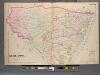
Monmouth County, Double Page Plate No. 30 [Map of Middle Township]
From Wolverton's atlas of Monmouth County, New Jersey : compiled from actual surveys, state and county official records and private plans.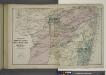
Portions of Middletown, Shrewsbury and Ocean Townships. [Townships]
from Atlas of Monmouth co., New Jersey. From recent and actual surveys and records, under the superintendence of F.W. Beers.
Long Branch
1 : 24000
Long Branch
1 : 24000
Long Branch
1 : 24000
Long Branch
1 : 24000
Long Branch
1 : 24000
Sandy Hook
1 : 24000
Sandy Hook
1 : 24000
Sandy Hook
1 : 24000
Sandy Hook
1 : 24000
Sandy Hook
1 : 24000
Sandy Hook
1 : 24000
Long Branch, N.J.
1 : 19200 Beers, F. W. (Frederick W.)
Asbury Park
1 : 24000
Asbury Park
1 : 24000
Asbury Park
1 : 24000
Asbury Park
1 : 24000
Asbury Park
1 : 24000
Asbury Park
1 : 24000
Asbury Park
1 : 24000
Asbury Park
1 : 24000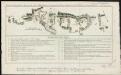
Plan de la bataille de Montmouth où le Gl. Washington commandait l'Armée Américaine et le Gl. Clinton l'Armée Anglaise, le 28 Juin 1778
1 : 30500 Hilliard d'Auberteuil, Michel René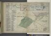
Long Beach Business Notices. ; Leedsville [Village]; Tinton Falls [Village]; Tinton Falls Business Notices. ; Shrewsbury [Village]; Monmouth Park and Oceanport [Villages]; Oceanport and Vicinity Monmouth Park Business Notices.
from Atlas of Monmouth co., New Jersey. From recent and actual surveys and records, under the superintendence of F.W. Beers.
[Plan of engagement with British ships near Red Bank, New Jersey, October 22 and 23, 1777]
Hazlewood, J.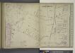
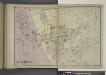
Portion of Long Branch [Village]
from Atlas of Monmouth co., New Jersey. From recent and actual surveys and records, under the superintendence of F.W. Beers.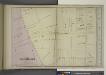
Portion of Long Branch [Village]
from Atlas of Monmouth co., New Jersey. From recent and actual surveys and records, under the superintendence of F.W. Beers.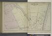
Portion of Long Branch [Village]
from Atlas of Monmouth co., New Jersey. From recent and actual surveys and records, under the superintendence of F.W. Beers.