Maps of Colts Neck Township
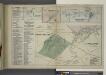
Long Beach Business Notices. ; Leedsville [Village]; Tinton Falls [Village]; Tinton Falls Business Notices. ; Shrewsbury [Village]; Monmouth Park and Oceanport [Villages]; Oceanport and Vicinity Monmouth Park Business Notices.
from Atlas of Monmouth co., New Jersey. From recent and actual surveys and records, under the superintendence of F.W. Beers.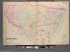
Monmouth County, Double Page Plate No. 30 [Map of Middle Township]
From Wolverton's atlas of Monmouth County, New Jersey : compiled from actual surveys, state and county official records and private plans.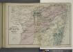
Portions of Middletown, Shrewsbury and Ocean Townships. [Townships]
from Atlas of Monmouth co., New Jersey. From recent and actual surveys and records, under the superintendence of F.W. Beers.
(Coast section no. 1. Sandy Hook to Shark River)
1 : 63360 Woolman, H. C.
Sandy Hook
1 : 62500
Sandy Hook
1 : 62500
Sandy Hook
1 : 62500
Sandy Hook
1 : 62500
Sandy Hook
1 : 62500
Sandy Hook
1 : 62500
Sandy Hook
1 : 62500
Sandy Hook
1 : 62500
Sandy Hook
1 : 62500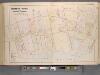
Monmouth County, Double Page Plate No. 6 [Map of Rumson Rd., and Adjaining Properties]
From Wolverton's atlas of Monmouth County, New Jersey : compiled from actual surveys, state and county official records and private plans.
9 Monmouth shore.
1 : 63360 Vermeule, C. C. (Cornelius Clarkson), 1858-1950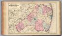
Monmouth Co., N.J.
1 : 126720 Beers, F. W. (Frederick W.)
Navesink
1 : 125000
Navesink
1 : 125000
Navesink
1 : 125000
Hammods Atlas of New York City and the metropolitan district

Chart of the entrance of Hudson's River, from Sandy Hook to New York : with the banks, depths of water, sailing-marks, & ca
1 : 70000 Printed for Robt. Sayer & John Bennett, sea chart & map-sellers ...
Map of New-York Bay and Harbor and the environs / founded upon a trigonometrical survey under the direction of F. R. Hassler, superintendent of the Survey of the Coast of the United States ; triangulation by James Ferguson and Edmund Blunt, assistants ;
from New York harbor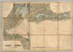
New York Bay And Harbor.
1 : 79200 United States Coast Survey
Chart and plan of the harbour of New York & the couny. adjacent, from Sandy Hook to Kingsbridge : comprehending the whole of New York and Staten Islands, and part of Long Island & the Jersey shore, and shewing the defences of New York both by land and se
from Whole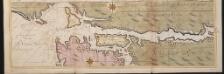
Nieuwe afteekeningh van de Noord Rivier met alle desselfs ancker plaetsen dieptens banken en klippen, geleegen in Nieuw Nederlandt [north part]
United States Gerard van Keulen
Chart and plan of the harbour of New York & the couny. adjacent, from Sandy Hook to Kingsbridge : comprehending the whole of New York and Staten Islands, and part of Long Island & the Jersey shore, and shewing the defences of New York both by land and se
from Cartographic materials from the Emmet Collection of Manuscripts Etc. Relating to American History.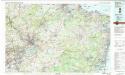
Trenton
1 : 100000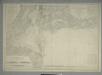
Map of New-York Bay and Harbor and the environs : [with colored manuscript additions to show positions of troops and fleets at the Battle of Long Island, 1776] / founded upon a trigonometrical survey under the direction of F.R. Hassler, superintendent of
from New York harbor
Watson's guide map to summer resorts around New York.
from Whole
![Long Beach Business Notices. ; Leedsville [Village]; Tinton Falls [Village]; Tinton Falls Business Notices. ; Shrewsbury [Village]; Monmouth Park and Oceanport [Villages]; Oceanport and Vicinity Monmouth Park Business Notices.](https://images-2.georeferencer.com/images/iiif/528349670993/full/,300/0/native.jpg)

