Maps of Middletown Township
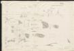
[Plan of engagement with British ships near Red Bank, New Jersey, October 22 and 23, 1777]
Hazlewood, J.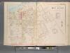
Monmouth County, Double Page Plate No. 25 [Map Bounded by North Shresbury River, Prospect St., Irving St., Maple Ave.]
From Wolverton's atlas of Monmouth County, New Jersey : compiled from actual surveys, state and county official records and private plans.
Long Branch
1 : 24000
Long Branch
1 : 24000
Long Branch
1 : 24000
Long Branch
1 : 24000
Long Branch
1 : 24000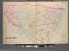
Monmouth County, Double Page Plate No. 30 [Map of Middle Township]
From Wolverton's atlas of Monmouth County, New Jersey : compiled from actual surveys, state and county official records and private plans.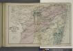
Portions of Middletown, Shrewsbury and Ocean Townships. [Townships]
from Atlas of Monmouth co., New Jersey. From recent and actual surveys and records, under the superintendence of F.W. Beers.
(Coast section no. 1. Sandy Hook to Shark River)
1 : 63360 Woolman, H. C.
Sandy Hook
1 : 62500
Sandy Hook
1 : 62500
Sandy Hook
1 : 62500
Sandy Hook
1 : 62500
Sandy Hook
1 : 62500
Sandy Hook
1 : 62500
Sandy Hook
1 : 62500
Sandy Hook
1 : 62500
Sandy Hook
1 : 62500
Facsimile of the unpublished British head quarters coloured manuscript map of New York & environs / reproduced from the original drawing in the War Office, London.
from Whole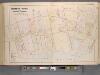
Monmouth County, Double Page Plate No. 6 [Map of Rumson Rd., and Adjaining Properties]
From Wolverton's atlas of Monmouth County, New Jersey : compiled from actual surveys, state and county official records and private plans.
9 Monmouth shore.
1 : 63360 Vermeule, C. C. (Cornelius Clarkson), 1858-1950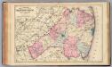
Monmouth Co., N.J.
1 : 126720 Beers, F. W. (Frederick W.)
Navesink
1 : 125000
Navesink
1 : 125000
Navesink
1 : 125000
Map of New-York Bay And Harbor And The Environs.
1 : 30600 United States Coast Survey
Map of New-York Bay and Harbor and the environs
1 : 30000 United States Coast Survey Survey of the Coast of the United States
Hammods Atlas of New York City and the metropolitan district

![[Plan of engagement with British ships near Red Bank, New Jersey, October 22 and 23, 1777]](https://images-2.georeferencer.com/images/iiif/593217258491/full/,300/0/native.jpg)

