Maps of Great Britain
Kriegs Atlas 36 Karten von den Schauplätzen des Weltkrieges 1914/1915
The coast of NORWAY from Naze to Paternosters and part of Iutland
from The sea-atlas : containing an hydrographical description of most of the sea-coasts of the known parts of the world.
Carte pour l'introduction à l'histoire d'Angleterre
1 Karte : Kupferdruck ; 21 x 25 cm, Bildgrösse 52 x 60 cm Châtelain s.n.
Paskaert van een gedeelte vande Noort Zee Streckende Van Harwitz en Egmon tot Stavanger [...] [Karte], in: De Nieuwe Groote Vermeerderde Zee-Atlas ofte Water-Werelt, S. 17.
1 Karte aus Atlas Doncker, Hendrick
Carte de la mer d'Allemagne
1 Karte : Kupferdruck ; 58 x 81 cm s.n.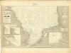
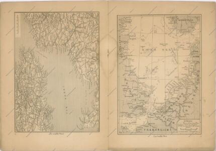
Museumskart 217-7: Kart over Nordsjøen
1 : 500000 S. A. Aarnes Den Geografiske Opmaaling
Et nyt forbedret retwisend söe-kaart over nord-söen
1 Karte auf 2 Blatt : Kupferdruck ; 79 x 96 cm + Höeg; Haas s.n.
Nieuwe platte kaart van de Noort Zee strekkende van Frederikstad tot de eylande Ornaal van Schagens Hoek langs de westkuste van Jutland, Holland, & Zeeland tot Middelburg : uit de jongste waarneeminge van Hoegs, Hammons Heiteman en verdere ervaren zeelieden verbeeterd
1 : 350000 Te Amsterdam : te zamengest. en uitg. door Gerard Hulst van Keulen
Homannův atlas světa
1 : 1920000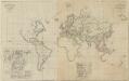
X. Charte für die allgemeine Geschichte vom Anfange des XXX-jährigen Krieges bis zur Selbstregierung Ludwig XIV : d.i. von 1618 bis 1661 n. Christus
Entworfen von F.W. Benicken A. Falger gr. Weimar : im Verlage des L. Industrie-Comptoirs
Letecká navigační mapa

County map of England and Wales.
from New general atlas.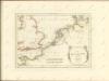

Carte des trois royaumes d'Angleterre d'Ècosse et d'Irlande
Velká Británie Raffelsperger, Franz Kitchin, Thomas
I, uit: General-Karte von Mittel-Europa in 12 Blättern, im Masse 1:1.200.000 / entworfen, bearb. und hrsg. von Josef Schlacher
1 : 1200000 Annotatie: Blad 6 ontbreekt; Annotatie geografische gegevens: 21 maatstokken op blad 9; Legenda op blad 9 Wien : K.K. Militär Geografisches Institut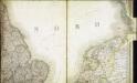
Carte des iles britanniques ou Royaume-Uni de la Grande Bretagne et d'Irlande, 4
2 Blätter : je 48 x 39 cm
Gross-Britanien und Irland
Velká Británie Raffelsperger, Franz Kitchin, Thomas Franz Raffelsperger

Konigreich Grossbrittanien und Irland
Velká Británie Raffelsperger, Franz Kitchin, Thomas
Die britischen Inseln
Velká Británie Wyld, James Kitchin, Thomas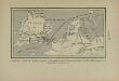
Carte de l’invasion saxonne en Grande-Bretagne. L’Heptarchie, fondée de 455 à 584 de notre ère
Großbritannien Angelsachsen Völkerwanderungszeit
[Velká Británie a Irsko]
Velká Británie Lotter, Tobias Conrad Lotter, Matthäus Albrecht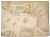
The North Sea with Vignette view of Towns, with London seen as if from the Thames
This is a map showing the North Sea from North Holland (Zuidersee) to Boulogne and Dover to Tynemouth. It dates from September October 1539 and is likely to have been drawn by the cartographer John Borough with decorative ships drawn by the King’s painter Anthony Anthony. John Borough was a sea man who possessed a wealth of knowledge on navigation. He was occasionally employed to sail along the Flemish coast to look for enemy ships. By 25th of October Henry VIII was reported as ordering the Calais authorities to prepare for Anne of Cleves who would journey to England via the English outpost. It is possible that this map could be the presentation copy for the Cleves envoys, illustrating how Anne of Cleves could be safely transported from north Holland to England. Vignette views of towns feature, with London seen from the Thames, where Anne would be deposited. The small ships that are drawn in the Zee and the large English ships with Royal standard outside, support this idea as they illustrate how Anne could be transferred from different sailing vessels. A squadron is shown blocking the channel from Dunkirk to Dover making possible a landing for Anne at the mouth of the Thames. The scale of the map is varied, with Zuidersee being drawn at a larger scale than elsewhere. [Borough, John a]
Bez titulu: Severozápadní Evropa

Pas-caert van Texel tot aen de Hoofden
1 Karte : Kupferdruck ; 43 x 53 cm Doncker bÿ Hendrick Doncker boekverkoper en graadbooghmaker in de Nieubrugsteegh in 't Stuurmans gereetschap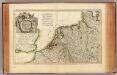
L'Alemagne 1.
1 : 1800000 Rizzi Zannoni, Giovanni Antonio Bartolomeo, 1736-1814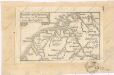
Soubor map

Skizze zur Orientirung ϋber den Feldzug 1814
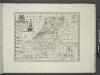
A new map of the Netherlands or Low Countries, shewing their principal divisions, cities, towns, rivers &c.
from A new sett of maps both of antient and present geography : wherein not only the latitude and longitude of many places are corrected according to the latest observations, but also the most remarkable differences of antient and present geography may be quickly discern'd by a bare inspection or comparing of correspondent maps, which seems to be the most natural and easy method to lead young students (for whose use the work is principally intended) unto a competent knowledge of the geographical science : together with a geographical treatise particularly adapted to the use and design of these maps / by Edward Wells, M.A. and student of Christ-Church, Oxon.