Maps of Lower Saxony
L'Alemagne 1.
1 : 1800000 Rizzi Zannoni, Giovanni Antonio Bartolomeo, 1736-1814

Pas-caert van Texel tot aen de Hoofden
1 Karte : Kupferdruck ; 43 x 53 cm Doncker bÿ Hendrick Doncker boekverkoper en graadbooghmaker in de Nieubrugsteegh in 't Stuurmans gereetschap
Carte de l’invasion saxonne en Grande-Bretagne. L’Heptarchie, fondée de 455 à 584 de notre ère
Großbritannien Angelsachsen Völkerwanderungszeit
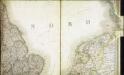
Bez titulu: Severozápadní Evropa

I, uit: General-Karte von Mittel-Europa in 12 Blättern, im Masse 1:1.200.000 / entworfen, bearb. und hrsg. von Josef Schlacher
1 : 1200000 Annotatie: Blad 6 ontbreekt; Annotatie geografische gegevens: 21 maatstokken op blad 9; Legenda op blad 9 Wien : K.K. Militär Geografisches Institut
S. North Sea ports.
1 : 1500000 Philip, George
L'Empire, d'Allemagne
1 : 1200000 Mollova mapová sbírka Sanson, Nicolas Quasy, Robert
Postarum seu Veredariorum Stationes Per Germaniam et Provincias Adiacentes.
1 : 400000 Mollova mapová sbírka Danckerts, Justus Danckerts, Cornelis
Nouvelle carte geographique des postes des Pais Bas, de la Westphalie, & des provinces limitrophes
1 : 1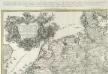
Kriegs Expeditions Karte von Devtschland
1 : 1700000 Mollova mapová sbírka Rizzi Zannoni, Giovanni Antonio Homann, Johann Baptista - dědici
Charte über die saemtlichen zum Westphaelischen Kreis gehörige Laender
1 : 840000 Evropa severozápadní Güssefeld, Franz L. bey den Homaennischen Erben
Grossdeutsches Reich und angrenzende Gebiete

Nouvelle Carte du Royaume des Pays - Bas et Pays Limithropes...
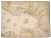
The North Sea with Vignette view of Towns, with London seen as if from the Thames
This is a map showing the North Sea from North Holland (Zuidersee) to Boulogne and Dover to Tynemouth. It dates from September October 1539 and is likely to have been drawn by the cartographer John Borough with decorative ships drawn by the King’s painter Anthony Anthony. John Borough was a sea man who possessed a wealth of knowledge on navigation. He was occasionally employed to sail along the Flemish coast to look for enemy ships. By 25th of October Henry VIII was reported as ordering the Calais authorities to prepare for Anne of Cleves who would journey to England via the English outpost. It is possible that this map could be the presentation copy for the Cleves envoys, illustrating how Anne of Cleves could be safely transported from north Holland to England. Vignette views of towns feature, with London seen from the Thames, where Anne would be deposited. The small ships that are drawn in the Zee and the large English ships with Royal standard outside, support this idea as they illustrate how Anne could be transferred from different sailing vessels. A squadron is shown blocking the channel from Dunkirk to Dover making possible a landing for Anne at the mouth of the Thames. The scale of the map is varied, with Zuidersee being drawn at a larger scale than elsewhere. [Borough, John a]
Carte des iles britanniques ou Royaume-Uni de la Grande Bretagne et d'Irlande, 4
2 Blätter : je 48 x 39 cm
Holland or the Seven United Provinces, and the Netherlands.
from Carey's general atlas, improved and enlarged : being a collection of maps of the world and quarters, their principal empires, kingdoms, &c.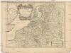
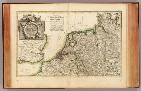
Les dix-sept provinces des Pays-Bas
1 : 1240000 Belgie Sanson, Guillaume Cordier, Louis chez H. Iaillot
Europe Centrale (Partie Occidentale).
1 : 1750000 Jouvet et Cie.
D.O.M. Carte Generale Des Dixsept Provinces des Pays-Bas avec les Frontieres de France, d'Allemagne et Partie de l'Angleterre Nouvellement dreßée sur plusieur Momoires tirés sur les Lieux pendant les Guerres
1 : 750000 Mollova mapová sbírka Sengre, Henri Misson, François Maximilien
Neue und richtige Landtafel der XVII Niderländische Provincien : abbildende alle befestigte, bemauerte, offene Stedte und Schantzen, etc.
1 : 1260000 Annotatie geografische gegevens: Noordwest boven Nürnberg : Jacob Sandrart
Tabula generalis totius Belgii
1 : 1000000 Belgie Homann, Johann Baptist á Iohanne Baptista Homanno
TABULA GENERALIS TOTIUS BELGII qua PROVINCIAE XVII. INFER. GERMANIAE olim sub S.R.I. CIRCULO BURGUNDIAE
1 : 1100000 Belgie Homann, Johann Baptist â Iohanne Baptista Homanno
Tabula generalis totius Belgii
1 : 1000000 Belgie Homann, Johann Baptist á Iohanne Baptista Homanno
Tabula generalis totius Belgii
1 : 1000000 Belgie Homann, Johann Baptist â Iohanne Baptista Homanno
Bojište [sic] 1870
Belgie Bedřich Sandtner
Descriptio Germaniae Inferioris. [Karte], in: Theatrum orbis terrarum, S. 162.
1 Karte aus Atlas Ortelius, Abraham Vrients, Jan Baptista
Belgii Veteris Typus [...] [Karte], in: Gerardi Mercatoris et I. Hondii Newer Atlas, oder, Grosses Weltbuch, Bd. 1, S. 361.
1 Karte aus Atlas Mercator, Gerhard und Hondius, Jodocus Jansson, Jan