Maps of England
Letecká navigační mapa
Soubor map
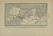
Carte de l’invasion saxonne en Grande-Bretagne. L’Heptarchie, fondée de 455 à 584 de notre ère
Großbritannien Angelsachsen Völkerwanderungszeit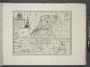
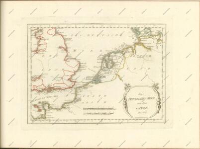
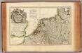
A new map of the Netherlands or Low Countries, shewing their principal divisions, cities, towns, rivers &c.
from A new sett of maps both of antient and present geography : wherein not only the latitude and longitude of many places are corrected according to the latest observations, but also the most remarkable differences of antient and present geography may be quickly discern'd by a bare inspection or comparing of correspondent maps, which seems to be the most natural and easy method to lead young students (for whose use the work is principally intended) unto a competent knowledge of the geographical science : together with a geographical treatise particularly adapted to the use and design of these maps / by Edward Wells, M.A. and student of Christ-Church, Oxon.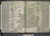
The south part of Great Britain, called England and Wales.
from The world described, or, A new and correct sett of maps : shewing the kingdoms and states in all the known parts of the earth, with the principal cities, and most considerable towns in the world ... / ... by Herman Moll, geographer ...
Bez titulu: Severozápadní Evropa
Museumskart 217-7: Kart over Nordsjøen
1 : 500000 S. A. Aarnes Den Geografiske Opmaaling
Nouvelle carte geographique des postes des Pais Bas, de la Westphalie, & des provinces limitrophes
1 : 1
Nouvelle Carte du Royaume des Pays - Bas et Pays Limithropes...
L'Alemagne 1.
1 : 1800000 Rizzi Zannoni, Giovanni Antonio Bartolomeo, 1736-1814
Tabula generalis totius Belgii
1 : 1000000 Belgie Homann, Johann Baptist á Iohanne Baptista Homanno
TABULA GENERALIS TOTIUS BELGII qua PROVINCIAE XVII. INFER. GERMANIAE olim sub S.R.I. CIRCULO BURGUNDIAE
1 : 1100000 Belgie Homann, Johann Baptist â Iohanne Baptista Homanno
Tabula generalis totius Belgii
1 : 1000000 Belgie Homann, Johann Baptist á Iohanne Baptista Homanno
Tabula generalis totius Belgii
1 : 1000000 Belgie Homann, Johann Baptist â Iohanne Baptista Homanno
Atlas für Handel und Industrie: Für Kaufleute, Fabrikante u. Gewerbetreibende, Handlungs- u. Gewerbe-Schulen

Der Deutsch-französische Kriegsschauplatz
1 : 900000 Evropa severozápadní König, Gustav Moriz Perles
Grossdeutsches Reich und angrenzende Gebiete

Birds eye view of the seat of War in Europe
1 : 1
Kriegs Atlas 36 Karten von den Schauplätzen des Weltkrieges 1914/1915
Central Europe.
1 : 2000000 Hughes, William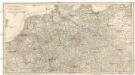
Carte itineraire de l'empire d'Allemagne et des frontieres
1 : 2140000 Německo
Carte Generale des Etats composant La Confederation Germanique.
1 : 2750000 Vivien de St Martin, L.
Bourgondische landen
1 : 1000000 Oirschot, P.E. van Groningen : Wolters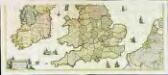
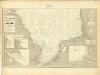
Nova totius Angliæ, Scotiæ, et Hiberniæ, tabula, 2
2 Blätter : 43 x 103 cm Danckerts
Nord-Westliches Deutschland, Niederlande und Belgien
Handatlas über alle Theile der Erde und über das Weltgebäude Stieler, Adolf Justus Perthes
Nord-Westliches Deutschland, Niederlande und Belgien
Hand-Atlas über alle Theile der Erde und über das Weltgebäude Stieler, Adolf Justus Perthes
Naauwkeurige kaart van het oude Nederland en eenige aangrenzende gewesten.
1 : 2000000 Isaak Tirion. Te Amsterdam : by Isaak Tirion
I, uit: General-Karte von Mittel-Europa in 12 Blättern, im Masse 1:1.200.000 / entworfen, bearb. und hrsg. von Josef Schlacher
1 : 1200000 Annotatie: Blad 6 ontbreekt; Annotatie geografische gegevens: 21 maatstokken op blad 9; Legenda op blad 9 Wien : K.K. Militär Geografisches Institut