Maps of Netherlands
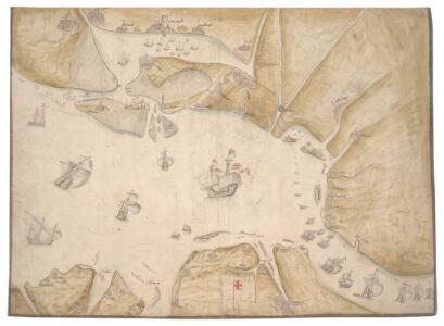
The North Sea with Vignette view of Towns, with London seen as if from the Thames
This is a map showing the North Sea from North Holland (Zuidersee) to Boulogne and Dover to Tynemouth. It dates from September October 1539 and is likely to have been drawn by the cartographer John Borough with decorative ships drawn by the King’s painter Anthony Anthony. John Borough was a sea man who possessed a wealth of knowledge on navigation. He was occasionally employed to sail along the Flemish coast to look for enemy ships. By 25th of October Henry VIII was reported as ordering the Calais authorities to prepare for Anne of Cleves who would journey to England via the English outpost. It is possible that this map could be the presentation copy for the Cleves envoys, illustrating how Anne of Cleves could be safely transported from north Holland to England. Vignette views of towns feature, with London seen from the Thames, where Anne would be deposited. The small ships that are drawn in the Zee and the large English ships with Royal standard outside, support this idea as they illustrate how Anne could be transferred from different sailing vessels. A squadron is shown blocking the channel from Dunkirk to Dover making possible a landing for Anne at the mouth of the Thames. The scale of the map is varied, with Zuidersee being drawn at a larger scale than elsewhere. [Borough, John a]
I, uit: General-Karte von Mittel-Europa in 12 Blättern, im Masse 1:1.200.000 / entworfen, bearb. und hrsg. von Josef Schlacher
1 : 1200000 Annotatie: Blad 6 ontbreekt; Annotatie geografische gegevens: 21 maatstokken op blad 9; Legenda op blad 9 Wien : K.K. Militär Geografisches Institut
Bez titulu: Severozápadní Evropa

Holland or the Seven United Provinces, and the Netherlands.
from Carey's general atlas, improved and enlarged : being a collection of maps of the world and quarters, their principal empires, kingdoms, &c.
L'Alemagne 1.
1 : 1800000 Rizzi Zannoni, Giovanni Antonio Bartolomeo, 1736-1814
Pas-caert van Texel tot aen de Hoofden
1 Karte : Kupferdruck ; 43 x 53 cm Doncker bÿ Hendrick Doncker boekverkoper en graadbooghmaker in de Nieubrugsteegh in 't Stuurmans gereetschap

XVII provinciae Belgii sive Germaniae inferioris priscis temporib. circulo Burgundico S. R. I. annumeratae quarum X. hodie maximam partem Hispaniarum non nullae Galliae regis ditioni subjacent, VII vero sub nomine foederatarum provinciar libertate gaudent
1 : 1050000 Belgie Seutter, Matthäus Mathaei Seutteri
Les Pays Bas.
1 : 2150000 Lattre, Jean
Mare Germanicum ab Amelandia ad promontoria Caleti et Doveræ
1 Karte : Kupferdruck ; 47 x 57 cm Renard by L. Renard
Descriptio Germaniae Inferioris. [Karte], in: Theatrum orbis terrarum, S. 42.
1 Karte aus Atlas Ortelius, Abraham
Niederlande, Belgien.
1 : 800000 Kiepert, Heinrich, 1818-1899
Carte de l'Angleterre avec les divisions Saxonnes
Anglie Raffelsperger, Franz Kitchin, Thomas
De groote Nederlandse stedenwyzer, vertoonende met een opslag des oogs, de afgelegentheden tussen 108 steden der XVII. provintien, of Beantwoording op 5786 vragen, hoe veel uuren gaans de eene plaats van den ander is gelegen = La grande echelle des Pais-Bas, qui montre du premier coup d’oeil, la distence de 108 villes, des XVII. provinces, ou Reponce sur 5786. demandes, pour savoir de quelle distence une ville est eloignée de l’autre
te samen gesteld en int ligt gegeeven door Jan de Lat kaart en boekverkoper tot Deventer. Deventer : Jan de Lat
Hollanda
[Giralomo Porro] [Venetië] : Simon Galignani ; Giralomo Porro]
S. North Sea ports.
1 : 1500000 Philip, George
Niederland u. Belgien
1 : 2220000 Belgie Stein, Carl
Les dix-sept provinces des Pays-Bas
1 : 1240000 Belgie Sanson, Guillaume Cordier, Louis chez H. Iaillot
Belgii Veteris Typus [...] [Karte], in: Gerardi Mercatoris et I. Hondii Newer Atlas, oder, Grosses Weltbuch, Bd. 1, S. 361.
1 Karte aus Atlas Mercator, Gerhard und Hondius, Jodocus Jansson, Jan
Belgii Veteris Typus. [Karte], in: Theatrum orbis terrarum, S. 470.
1 Karte aus Atlas Ortelius, Abraham Vrients, Jan Baptista
XVII provinciae Belgii sive Germaniae inferioris
1 : 1682000 Belgie Lotter, Tobias Conrad Rogg, Gottfried studio et opera Tobiae Conradi Lotter
XVII provinciae Belgii sive Germaniae inferioris
1 : 1682000 Belgie Lotter, Tobias Conrad Rogg, Gottfried opera Tobiae Conradi Lotter
XVII provinciae Belgii sive Germaniae inferioris
1 : 1682000 Belgie Lotter, Tobias Conrad Rogg, Gottfried T. C. Lotter
Homannův atlas světa
1 : 7000000
Naauwkeurige kaart van het oude Nederland en eenige aangrenzende gewesten.
1 : 2000000 Isaak Tirion. Te Amsterdam : by Isaak Tirion

Belgii Veteris [Karte], in: Novus atlas absolutissimus, Bd. 3, S. 8.
1 Karte aus Atlas Janssonius Offizin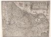
Inferioris Germaniae provinciarum nova descriptio / [Willem Jansz. Blaeu]
1 : 900000 Annotatie: Onder de titel een nadere omschrijving in het Latijn en Nederlands; Aan het oorspronkelijke kaartbeeld zijn het Bourtangerveen en Fort Bourtange toegevoegd; Lit.: Monumenta cartografica Neerlandica, IV, p. 31-32, 146-153, facs. 5; Oorspr. uitg.: 1604 Blaeu, Willem Jansz. Amstelodami : ex officina Guilielmi Johannis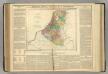
Netherlands.
1 : 1950000 Lavoisne, M.