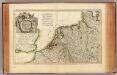
Maps of Netherlands

Paskaert van een gedeelte vande Noort Zee Streckende Van Harwitz en Egmon tot Stavanger [...] [Karte], in: De Nieuwe Groote Vermeerderde Zee-Atlas ofte Water-Werelt, S. 17.
1 Karte aus Atlas Doncker, Hendrick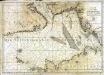
Carte de la mer d'Allemagne
1 Karte : Kupferdruck ; 58 x 81 cm s.n.
Nieuwe platte kaart van de Noort Zee strekkende van Frederikstad tot de eylande Ornaal van Schagens Hoek langs de westkuste van Jutland, Holland, & Zeeland tot Middelburg : uit de jongste waarneeminge van Hoegs, Hammons Heiteman en verdere ervaren zeelieden verbeeterd
1 : 350000 Te Amsterdam : te zamengest. en uitg. door Gerard Hulst van Keulen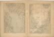
Kriegs Atlas 36 Karten von den Schauplätzen des Weltkrieges 1914/1915

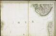
Et nyt forbedret retwisend söe-kaart over nord-söen
1 Karte auf 2 Blatt : Kupferdruck ; 79 x 96 cm + Höeg; Haas s.n.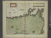
The coast of NORWAY from Naze to Paternosters and part of Iutland
from The sea-atlas : containing an hydrographical description of most of the sea-coasts of the known parts of the world.
correct chart of the North Sea, with the adjacent coasts of Britain, Holland, Germany, Denmark, Norway, the islands of Orkney and Shetland, the entrance to the Sound and the Baltic Sea
1 : 3400000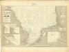
Museumskart 217-7: Kart over Nordsjøen
1 : 500000 S. A. Aarnes Den Geografiske Opmaaling
Carte des trois royaumes d'Angleterre d'Ècosse et d'Irlande
Velká Británie Raffelsperger, Franz Kitchin, Thomas
Die britischen Inseln
Velká Británie Wyld, James Kitchin, Thomas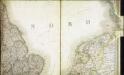
Carte des iles britanniques ou Royaume-Uni de la Grande Bretagne et d'Irlande, 4
2 Blätter : je 48 x 39 cm
Skizze zur Orientirung ϋber den Feldzug 1814
Carte des iles britanniques ou Royaume-Uni de la Grande Bretagne et d'Irlande, 2
2 Blätter : je 50 x 39 cm
Gross-Britanien und Irland
Velká Británie Raffelsperger, Franz Kitchin, Thomas Franz Raffelsperger
[Velká Británie a Irsko]
Velká Británie Lotter, Tobias Conrad Lotter, Matthäus Albrecht
Konigreich Grossbrittanien und Irland
Velká Británie Raffelsperger, Franz Kitchin, Thomas
Table des latitudes et longitudes des principaux lieux du royaume d'Escosse
1 : 55200 Skotsko Fer, Nicolas de Vilém Oranžský N. de Fer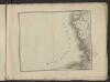
Théatre de la guerre actuelle, en Allemagne, en Pologne et en Turquie. n2 (bis)
1 : 900000 Chanlaire, Pierre Grégoire 1758-1817 Paris : chez l'auteur P. G. Chanlaire
Scotia regnum
1 : 870000 Skotsko Wit, Frederick de Vilém Oranžský F. de Wit
L'Alemagne 1.
1 : 1800000 Rizzi Zannoni, Giovanni Antonio Bartolomeo, 1736-1814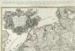
Kriegs Expeditions Karte von Devtschland
1 : 1700000 Mollova mapová sbírka Rizzi Zannoni, Giovanni Antonio Homann, Johann Baptista - dědici
E. ports Gt. Brit.
1 : 1500000 Philip, George
I, uit: General-Karte von Mittel-Europa in 12 Blättern, im Masse 1:1.200.000 / entworfen, bearb. und hrsg. von Josef Schlacher
1 : 1200000 Annotatie: Blad 6 ontbreekt; Annotatie geografische gegevens: 21 maatstokken op blad 9; Legenda op blad 9 Wien : K.K. Militär Geografisches Institut
[124][127] Daniae, Frisiae, Groningae et Orientalis Frisiae littora, uit: Atlas sive Descriptio terrarum orbis
Annotatie: Gedigitaliseerde versie. Amsterdam. Heiloo : Picturae (vervaardiger), 2015. tiff-bestand. Gedigitaliseerd: 07-01-2015; Origineel: Universiteitsbibliotheek Vrije Universiteit (XL.05127.-) ; Netherlands; Titelpagina ontbreekt Wit, Frederik de Amsterdam : Frederick de Wit
Pas-caert van Texel tot aen de Hoofden
1 Karte : Kupferdruck ; 43 x 53 cm Doncker bÿ Hendrick Doncker boekverkoper en graadbooghmaker in de Nieubrugsteegh in 't Stuurmans gereetschap
S. North Sea ports.
1 : 1500000 Philip, George
The North Sea with Vignette view of Towns, with London seen as if from the Thames
This is a map showing the North Sea from North Holland (Zuidersee) to Boulogne and Dover to Tynemouth. It dates from September October 1539 and is likely to have been drawn by the cartographer John Borough with decorative ships drawn by the King’s painter Anthony Anthony. John Borough was a sea man who possessed a wealth of knowledge on navigation. He was occasionally employed to sail along the Flemish coast to look for enemy ships. By 25th of October Henry VIII was reported as ordering the Calais authorities to prepare for Anne of Cleves who would journey to England via the English outpost. It is possible that this map could be the presentation copy for the Cleves envoys, illustrating how Anne of Cleves could be safely transported from north Holland to England. Vignette views of towns feature, with London seen from the Thames, where Anne would be deposited. The small ships that are drawn in the Zee and the large English ships with Royal standard outside, support this idea as they illustrate how Anne could be transferred from different sailing vessels. A squadron is shown blocking the channel from Dunkirk to Dover making possible a landing for Anne at the mouth of the Thames. The scale of the map is varied, with Zuidersee being drawn at a larger scale than elsewhere. [Borough, John a]
Postarum seu Veredariorum Stationes Per Germaniam et Provincias Adiacentes.
1 : 400000 Mollova mapová sbírka Danckerts, Justus Danckerts, Cornelis
![Paskaert van een gedeelte vande Noort Zee Streckende Van Harwitz en Egmon tot Stavanger [...] [Karte], in: De Nieuwe Groote Vermeerderde Zee-Atlas ofte Water-Werelt, S. 17.](https://images-2.georeferencer.com/images/iiif/742500793443/full/,300/0/native.jpg)

