Maps of Germany
Soubor map
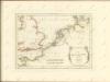
A new map of the Netherlands or Low Countries, shewing their principal divisions, cities, towns, rivers &c.
from A new sett of maps both of antient and present geography : wherein not only the latitude and longitude of many places are corrected according to the latest observations, but also the most remarkable differences of antient and present geography may be quickly discern'd by a bare inspection or comparing of correspondent maps, which seems to be the most natural and easy method to lead young students (for whose use the work is principally intended) unto a competent knowledge of the geographical science : together with a geographical treatise particularly adapted to the use and design of these maps / by Edward Wells, M.A. and student of Christ-Church, Oxon.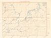
Letecká navigační mapa

Birds eye view of the seat of War in Europe
1 : 1
Der Deutsch-französische Kriegsschauplatz
1 : 900000 Evropa severozápadní König, Gustav Moriz Perles
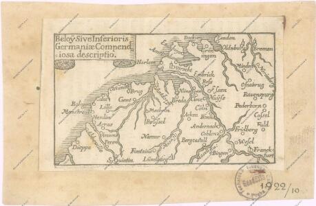
Tabula generalis totius Belgii
1 : 1000000 Belgie Homann, Johann Baptist á Iohanne Baptista Homanno
TABULA GENERALIS TOTIUS BELGII qua PROVINCIAE XVII. INFER. GERMANIAE olim sub S.R.I. CIRCULO BURGUNDIAE
1 : 1100000 Belgie Homann, Johann Baptist â Iohanne Baptista Homanno
Tabula generalis totius Belgii
1 : 1000000 Belgie Homann, Johann Baptist á Iohanne Baptista Homanno
Tabula generalis totius Belgii
1 : 1000000 Belgie Homann, Johann Baptist â Iohanne Baptista Homanno
Nouvelle Carte du Royaume des Pays - Bas et Pays Limithropes...
Carte de l’invasion saxonne en Grande-Bretagne. L’Heptarchie, fondée de 455 à 584 de notre ère
Großbritannien Angelsachsen Völkerwanderungszeit
D.O.M. Carte Generale Des Dixsept Provinces des Pays-Bas avec les Frontieres de France, d'Allemagne et Partie de l'Angleterre Nouvellement dreßée sur plusieur Momoires tirés sur les Lieux pendant les Guerres
1 : 750000 Mollova mapová sbírka Sengre, Henri Misson, François Maximilien
Central Europe.
1 : 2000000 Hughes, William
Royaume des Pays-Bas. Europe 13.
1 : 1641836 Vandermaelen, Philippe, 1795-1869
Bez titulu: Severozápadní Evropa

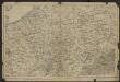
Descriptio Germaniae Inferioris. [Karte], in: Theatrum orbis terrarum, S. 162.
1 Karte aus Atlas Ortelius, Abraham Vrients, Jan Baptista
Unsere Westgrenze
1 : 1000000 Evropa západní Velhagen & Klasing
Atlas für Handel und Industrie: Für Kaufleute, Fabrikante u. Gewerbetreibende, Handlungs- u. Gewerbe-Schulen

Europe Centrale (Partie Occidentale).
1 : 1750000 Jouvet et Cie.
[Recto], uit: Descriptio Germaniae Inferioris
1 : 1000000 Annotatie: Waarschijnlijk gegraveerd door F. Hogenberg; Uit: Theatrum Orbis Terrarm. - Antwerpen, 1570 Hogenberg, Franz [Antwerpen : Abraham Ortelius]
Descriptio Germaniae Inferioris. [Karte], in: Theatrum orbis terrarum, S. 42.
1 Karte aus Atlas Ortelius, Abraham
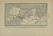
Bojište [sic] 1870
Belgie Bedřich Sandtner
Bourgondische landen
1 : 1000000 Oirschot, P.E. van Groningen : Wolters
Charte von Deutschland zu dem Meilen-Zeiger
1 : 222000 Německo Schreiber, Johann Georg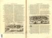
Germania Parte Occidentale
1 : 2100000 Mollova mapová sbírka Coronelli, Vincenzo Maria
Germania Parte Occidentale
1 : 2100000 Mollova mapová sbírka Coronelli, Vincenzo Maria
West Deutschland und Ost Frankreich, Niederlande und Belgien
1 : 2000000 Belgie Kozenn, B. Hölzel, Eduard Ed. Hölzel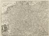
Carte von Ober u. Nieder Teutschland
1 : 4500000 Mollova mapová sbírka Vogel