Maps of Germany

Extract einer General-Post-Chartre von allen Pos routen durch gantz Teutschland und dessen gewöhnliche X. Creisse in benachbarte Länder
1 : 5800000 Mollova mapová sbírka Weigel, Christoph Weigel, Christoph I.
Postarum seu Veredariorum Stationes per Germaniam et Provincias Adiacentes
1 : 2500000 Mollova mapová sbírka Schenk, Pieter Schenk, Peter I
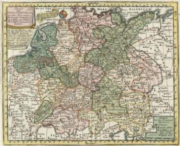
Die Zehen Kraise des H. Römischen Reichs
1 : 3400000 Mollova mapová sbírka
Nova Totivs Germaniae Descriptio
1 : 3500000 Mollova mapová sbírka Walter, A. Walter, Anton
Nova Totivs Germaniae Descriptio
1 : 3300000 Mollova mapová sbírka Blaeu, Willem Janszoon Blaeu, Joan I.
Empire d'Allemagne avec le royaume de Boheme, la Silesie, & c
1 : 5140000 Německo Bonne, Rigobert André
L'Empire d'Allemagne
1 : 2500000 Mollova mapová sbírka Jaillot, Alexis-Hubert Jaillot, Alexis Hubert
Post Karte durch ganz Deutschland, nach den allerneusten Nachrichten entworfen
1 : 2250000 In Augsburg : zu haben bei Joh. Walch
NOVA TOTIVS GERMANIÆ DESCRIPTIO
[Amsterdam : Joan Blaeu]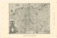
Die Ältesten Karten von Deutschland

Eisenbahnen in Deutschland und dessen Grenzlaendern
1 : 6200000 Evropa střední Radefeld Zipter, J. geographischen Anstalt des Bibliographischen Instituts
Deutschland und anliegende Länder zur Übersicht, d Hauptstr. u. Entfernungen zw. Paris, Mailand, Warschau u. Königsberg
1 : 3800000 Evropa střední Stieler, Adolf Justus Perthes
Post- u. Reise- Karte von Deutschland und den angränzenden Ländern bis Paris, Lyon, Turin, Mailand, Warschau u. Königsberg
1 : 1970000 Evropa střední Streit, Friedrich Wilhelm Stein, Johann Adam Johann Adam Stein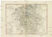
CHARTE von DEUTSCHLAND
1 : 3600000 Německo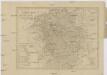
Charte von Deutschland
1 : 3580000 Evropa střední
Historia Imperii Romano-Germanici, nec non finitimarum Regionum In Mappa exhibita, ac aeri incisa
1 : 2500000 Mollova mapová sbírka Seutter, Matthäus Seutter, Matthäus
Neu-vermehrte Post-Charte durch gantz Teutschland nach Italien, Franckreich, Niederland, Preußen, Polen, und Ungarn ec
1 : 2470000 Německo Nell, Johann Peter Paar, Carl Joseph von Iohann Baptist Homann
Neu-vermehrte POST-CHARTE durch gantz TEUTSCHLAND nach Italien, Franckreich, Niederland, Preußen, Polen, und Ungarn etc
1 : 2600000 Evropa střední Nell, Johann Peter Homann, Johann Baptist Iohann Baptist Homann
[Neu-vermehrte Post-Charte durch gantz Teutschland nach Italien, Franckreich, Niederland, Preußen, Polen, und Ungarn etc
1 : 2470000 Francie Nell, Johann Peter Homann, Johann Baptist Iohann Baptist Homann
Neu-vermehrte Post-Charte durch gantz Teutschland nach Italien, Franckreich, Niederland, Preußen, Polen, und Ungarn etc
1 : 2470000 Francie Nell, Johann Peter Homann, Johann Baptist Iohann Baptist Homann
Neu-vermehrte Post-Charte durch gantz Teutschland nach Italien, Franckreich, Niederland, Preußen, Polen, und Ungarn etc
1 : 2470000 Francie Nell, Johann Peter Homann, Johann Baptist Iohann Baptist Homann
L'Allemagne divisée en ses cercles
1 : 2500000 Mollova mapová sbírka Fer, Nicolas de Loon, Herman van Fer, Nicolas de
L'Allemagne divisée en ses cercles
1 : 2500000 Mollova mapová sbírka Fer, Nicolas de Loon, Herman van Fer, Nicolas de
Germany.
1 : 6000000 Carey, Mathew
Germany.
1 : 6000000 Carey, Mathew
Karte von Teutschland
Německo Ritter, C.

Karte von Central-Europa bis Paris, Mailand, Triest, Pesth, Krakau, Königsberg, Schleswig
1 : 1800000 Budapešť (Maďarsko) Justus Perthes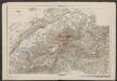
Germaniae nova et accurata delineatio [Karte], in: Gerardi Mercatoris et I. Hondii Newer Atlas, oder, Grosses Weltbuch, Bd. 1, S. 142.
1 Karte aus Atlas Mercator, Gerhard und Hondius, Jodocus Jansson, Jan