Maps of Germany

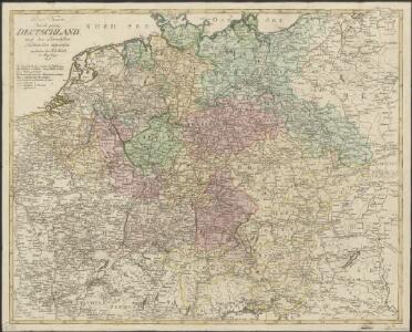
Post Karte durch ganz Deutschland, nach den allerneusten Nachrichten entworfen
1 : 2250000 In Augsburg : zu haben bei Joh. Walch
Eisen-Bahn-Atlas von Deutschland, Belgien, Elsass und dem nördlichsten Theile von Italien
Stülpnagel, Friedrich von ; Bär, J.C. Justus Perthes
Deutschland und anliegende Länder, zur Übersicht der Eisenbahnen und Hauptstrassen
Hand-Atlas über alle Theile der Erde nach dem neuesten Zustande und über das Weltgebäude Stieler, Adolf bei Justus Perthes
Charte das Deutsche Reich nach seinen Kreisen und deren Unterabtheilungen vorstellend
1 : 2660000 Francie Güssefeld, Franz L. von den Homännischen Erben
Charte das Deutsche Reich nach seinen Kreisen und deren Unterabtheilungen vorstellend
1 : 2660000 Evropa střední Güssefeld, Franz L. von den Homännischen Erben
Karte von Teutschland
Německo Ritter, C.
Neue und vollstaendige Postkarte durch ganz Deutschland und durch die angränzenden Theile der benachbarten Länder
1 : 1465000 Evropa střední Thurn-Taxis, Karel Anselm von denen Homaennischen Erben
Neue und vollstaendige Postkarte durch ganz Deutschland und durch die angränzenden Theile der benachbarten Länder
1 : 1465000 Evropa střední Thurn-Taxis, Karel Anselm von denen Homaennischen Erben
Neue und vollständige Postkarte durch ganz Deutschland und durch die angränzende Theile der benachbarten Länder
1 : 1465000 Evropa střední Heger, Franz Joseph Emmerich Joseph von denen Homaennischen Erben
Germany.
1 : 6000000 Carey, Mathew
Germany.
1 : 6000000 Carey, Mathew
Societas Iesu Germana Sive Assistentia Germaniae
1 : 2600000 Mollova mapová sbírka Seutter, Matthäus Seutter, Georg Matthäus Seutter, Matthäus
Imperium Romano-Germanicum in suos circulos electorat. et status
1 : 5100000 Evropa střední Seutter, Matthäus Lotter, Tobias Conrad apud Matth. Seutter
Kharte von Deutschland nach der neuesten Eintheilung, zufolge der Bestimmung des Wiener Congresses und des Pariser Frieden von 1815 entworfen
1 : 2300000 Augsburg : bei Joh. Walch
Neu-vermehrte Post-Charte durch gantz Teutschland nach Italien, Franckreich, Niederland, Preußen, Polen, und Ungarn ec
1 : 2470000 Německo Nell, Johann Peter Paar, Carl Joseph von Iohann Baptist Homann
Neu-vermehrte POST-CHARTE durch gantz TEUTSCHLAND nach Italien, Franckreich, Niederland, Preußen, Polen, und Ungarn etc
1 : 2600000 Evropa střední Nell, Johann Peter Homann, Johann Baptist Iohann Baptist Homann
[Neu-vermehrte Post-Charte durch gantz Teutschland nach Italien, Franckreich, Niederland, Preußen, Polen, und Ungarn etc
1 : 2470000 Francie Nell, Johann Peter Homann, Johann Baptist Iohann Baptist Homann
Neu-vermehrte Post-Charte durch gantz Teutschland nach Italien, Franckreich, Niederland, Preußen, Polen, und Ungarn etc
1 : 2470000 Francie Nell, Johann Peter Homann, Johann Baptist Iohann Baptist Homann
Neu-vermehrte Post-Charte durch gantz Teutschland nach Italien, Franckreich, Niederland, Preußen, Polen, und Ungarn etc
1 : 2470000 Francie Nell, Johann Peter Homann, Johann Baptist Iohann Baptist Homann
Nova totius Germaniae Descriptio Teütschland
1 : 4300000 Mollova mapová sbírka Merian, Matthaeus Merian, Matthäus
Allgemeine Postkarte von Deutschland zur Uebersicht
Německo Alberti, Ignaz im von Reillyschen Landkarten und Kunstwerke Verschleiss Komptoir
Deutschland und anliegende Länder, zur Übersicht der Hauptstrassen und Entfernungen
Hand-Atlas über alle Theile der Erde nach dem neuesten Zustande und über das Weltgebäude Stieler, Adolf bei Justus Perthes

General Charte von Teutschland mit Angabe aller Post-Strassen von Paris bis Warschau, und von Triest bis Stralsund
1 : 1760000 Evropa střední Güssefeld, Franz L. Geograph. Institut
CHARTE von DEUTSCHLAND
1 : 3600000 Německo
Charte von Deutschland
1 : 3580000 Evropa střední
Regni Germaniae partium originariarum, ex quibus olim conslatum est facies hodierna ad Circulorum divisionem applicata
1 : 7900000 Mollova mapová sbírka Franz, Johann Michael Homann, Johann Baptista - dědici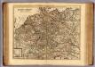
Carte exacte des postes et routes de l'Empire d'Allemagne divisee en ses cercles.
1 : 2500000 Covens et Mortier
Charte von Deutschland