Maps of Germany

Historia Imperii Romano-Germanici, nec non finitimarum Regionum In Mappa exhibita, ac aeri incisa
1 : 2500000 Mollova mapová sbírka Seutter, Matthäus Seutter, Matthäus
Carte exacte des postes et routes de l'Empire d'Allemagne divisee en ses cercles.
1 : 2500000 Covens et Mortier
Neu-vermehrte Post-Charte durch gantz Teutschland nach Italien, Franckreich, Niederland, Preußen, Polen und Ungarn &c.
1 : 2500000 Mollova mapová sbírka Nell, Johann Peter Homann, Johann Baptista

Post und Reise Karte von Deutschland und den benachbarten Ländern
Evropa střední Schmitfeldt, Georg Mollo, Eduard bey Eduard Mollo
Karte von Teutschland
Německo Ritter, C.
Karte von Deutschland
1 : 1880000 Evropa střední Reilly, Franz Johann Josef von Benedicti, Hieronymus Franz Joh. Jos. von Reilly
Karte von Deutschland
1 : 1880000 Evropa střední Reilly, Franz Johann Josef von Benedicti, Hieronymus Franz Joh. Jos. von Reilly
Karte von Deutschland nach Sotzmann
1 : 1880000 Německo Reilly, Franz Johann Josef von Benedicti, Hieronymus Franz Joh. Jos. von Reilly
Germany.
1 : 6000000 Carey, Mathew
Germany.
1 : 6000000 Carey, Mathew
Societas Iesu Germana Sive Assistentia Germaniae
1 : 2600000 Mollova mapová sbírka Seutter, Matthäus Seutter, Georg Matthäus Seutter, Matthäus
Deutschland von 1495 bis 1618.
1 : 3800000 Spruner von Merz, Karl
Eisen-Bahn-Atlas von Deutschland, Belgien, Elsass und dem nördlichsten Theile von Italien
Stülpnagel, Friedrich von ; Bär, J.C. Justus Perthes

Neu-vermehrte Post-Charte durch gantz Teutschland nach Italien, Franckreich, Niederland, Preußen, Polen, und Ungarn ec
1 : 2470000 Německo Nell, Johann Peter Paar, Carl Joseph von Iohann Baptist Homann
Neu-vermehrte POST-CHARTE durch gantz TEUTSCHLAND nach Italien, Franckreich, Niederland, Preußen, Polen, und Ungarn etc
1 : 2600000 Evropa střední Nell, Johann Peter Homann, Johann Baptist Iohann Baptist Homann
[Neu-vermehrte Post-Charte durch gantz Teutschland nach Italien, Franckreich, Niederland, Preußen, Polen, und Ungarn etc
1 : 2470000 Francie Nell, Johann Peter Homann, Johann Baptist Iohann Baptist Homann
Neu-vermehrte Post-Charte durch gantz Teutschland nach Italien, Franckreich, Niederland, Preußen, Polen, und Ungarn etc
1 : 2470000 Francie Nell, Johann Peter Homann, Johann Baptist Iohann Baptist Homann
Neu-vermehrte Post-Charte durch gantz Teutschland nach Italien, Franckreich, Niederland, Preußen, Polen, und Ungarn etc
1 : 2470000 Francie Nell, Johann Peter Homann, Johann Baptist Iohann Baptist Homann
Neu vermehrte Post Charte durch gantz Teutschland nach Italien, Franckreich, Niederland, Preußen, Polen, und Ungarn & c
1 : 2600000 Evropa střední Nell, Johann Peter Homann, Johann Baptist Iohann Baptist Homann
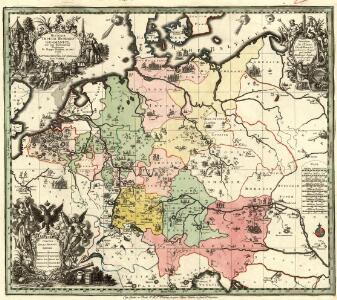
Imperium Romano-Germanicum in suos circulos electorat. et status
1 : 5100000 Evropa střední Seutter, Matthäus Lotter, Tobias Conrad apud Matth. Seutter
Neueste Post- und Eisenbah-Charte von Deutschland und der angränzenden Ländern für Extraposten, Couriere, Diligengen, u. Eilwägen
Belgie Bauer & Raspe
Deutschland von 1792 bis zur Gegenwart.
1 : 3800000 Spruner von Merz, Karl
Neue und vollstandige Postkarte durch ganz Deutschland
1 : 1480000 Německo Bors zu Overen, Johann Jakob Breidbach zu Bürresheim, Emmerich Joseph von bey dennen Homaennischen Erben
Germaniae nova et accurata delineatio [Karte], in: Novus atlas absolutissimus, Bd. 2, S. 13.
1 Karte aus Atlas Janssonius Offizin
Eisenbahnen in Deutschland und dessen Grenzlaendern
1 : 6200000 Evropa střední Radefeld Zipter, J. geographischen Anstalt des Bibliographischen Instituts
L'Allemagne divisée en ses cercles
1 : 2500000 Mollova mapová sbírka Fer, Nicolas de Loon, Herman van Fer, Nicolas de
L'Allemagne divisée en ses cercles
1 : 2500000 Mollova mapová sbírka Fer, Nicolas de Loon, Herman van Fer, Nicolas de