Maps of Poland

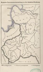
Russische Gouvernementseinteilung vor der deutschen Besatzung
Baltikum Kurland (Gouvernement) Ėstljandskaja Gubernija Riga (Gouvernement)
Übersichtskarte des Östlichen Kriegsschauplatzes
1 : 4500000 Osteuropa Polen Litauen Weißrussland Galizien und Lodomerien Weltkrieg <1914-1918> Verl. Gerhard Stalling, Oldenburg
Nr. 15. Der Krieg in Westrußland im Herbst 1915
Polen Weltkrieg <1914-1918>, Ostfront
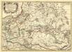
Poland, Prussia.
1 : 4400000 Darton, William
Poland.
1 : 2400000 Playfair, Principal
Östlicher Kriegsschauplatz I
1 : 5000000 Ostmitteleuropa Weltkrieg <1914-1918>, Ostfront
Carte géologique de la République Polonaise
1 : 2500000 Kuźniar, Czesław; (Pologne) Service Géologique Lwów : Service Géologique de Pologne
Západní Rusko a přilehlé části říše Německé a Rakousko-Uherska
1 : 1250000 Německo východní Machát, František V. Neubert
Magni Ducatus Lithuaniae, Caeterarumque Regionum Illi Adiacentium Exacta Descriptio [Karte], in: Le théâtre du monde, ou, Nouvel atlas contenant les chartes et descriptions de tous les païs de la terre, Bd. 1, S. 82.
1 Karte aus Atlas Blaeu, Willem Janszoon und Blaeu, Joan Blaeu, Willem Janszoon
Het Koningkryk Polen, volgens de nieuwste waarneminge opgesteld
1 : 16000000 te Amsterdam : bij S. v. Esveldt
Magni Ducatus Lithuaniae, Caeterarumque Regionum Illi Adiacentium Exacta Descriptio [...] [Karte], in: Novus Atlas, das ist, Weltbeschreibung, Bd. 1, S. 68.
1 Karte aus Atlas Blaeu, Joan Blaeu, Willem Janszoon
Poland.
1 : 3576320 Cummins Map Co.
Magni Ducatus Lithuaniae, caeterarumque Regionum Illi Adiacentium Exacta Descriptio [Karte], in: Theatrum orbis terrarum, sive, Atlas novus, Bd. 1, S. 84.
1 Karte aus Atlas Blaeu, Joan Blaeu, Willem Janszoon
Germano - Sarmatia in qua Populi maiores Venedi et Aestiaei Peucini et Bastarnae in minores Populos divisi ad hodiernam locorum, et Redionum positionem respondent
1 : 2900000 Mollova mapová sbírka Sanson, Nicolas Covens, Johannes I
Karta voennych dějstvīj 1768 - 1771 i 1794 g.g.
Polen Krieg
Východní fronta 1914

Map of the several countries thro' which the Russians are to pass in their march to Prussia
1 : 5259000
Royaume de Pologne et duché de Lithuanie
1 : 5180000 Litva Bonne, Rigobert André
Polen
1 : 1280000 Bělorusko Rizzi Zannoni, Giovanni Antonio Artaria
Polen
1 : 1280000 Bělorusko Rizzi Zannoni, Giovanni Antonio Artaria
Carte de Nouve au Royaume de Polonge.
1 : 4500000 Vivien de St Martin, L.
Magni dvcatvs Lithvaniae, caeterarvmqve regionvm illi adiacentivm exacta descriptio / sculptum apud
1 : 1300000 1 Karte auf 4 Blatt : Kupferdruck ; 73 x 71 cm Blaeu, Willem Janszoon excudebat Guilhelmus Janssonius sub signo solarij deaurati
Deutsch-österreich-russische Grenze
Polen Grenze
Die Ostsee-Laender, Polen und Litthauen im Aufange des XIIIten. Jahrhunderts.
1 : 3800000 Spruner von Merz, Karl
Preussen und Warschau
Allgemeiner Atlas [Walch, Johannes] im Verlag bei Johannes Walch
Feuille 25 (D IV), uit: Carte géologique internationale de l'Europe : la carte, votée au congrès géologique international de Bologne en 1881, est exécutée conformément aux décisions d'une commission internationale, avec le concours des gouvernements, sous le dir. de M.M. Beyrich et Hauchecorne
Annotatie: Blad 48 gamme des couleurs; blad 49: bladwijzer en titelblad Heinrich Ernst Beyrich 1815-1896; Wi. Hauchecorne Berlin : Reimer / (Berlin: Institut lithographique)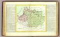
Prusse, Lithuanie.
1 : 3200000 Clouet, J. B. L. (Jean-Baptiste Louis), b. 1730
Republika polská
1 : 1000000 Bělorusko