Maps of Poland

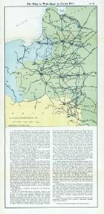
Nr. 15. Der Krieg in Westrußland im Herbst 1915
Polen Weltkrieg <1914-1918>, Ostfront
Carte géologique de la République Polonaise
1 : 2500000 Kuźniar, Czesław; (Pologne) Service Géologique Lwów : Service Géologique de Pologne
Übersichtskarte des Östlichen Kriegsschauplatzes
1 : 4500000 Osteuropa Polen Litauen Weißrussland Galizien und Lodomerien Weltkrieg <1914-1918> Verl. Gerhard Stalling, Oldenburg
Západní Rusko a přilehlé části říše Německé a Rakousko-Uherska
1 : 1250000 Německo východní Machát, František V. Neubert
Neueste karte von Polen und Lithauen nebst Theilen der angränzenden Länder
Litva C. Hoffmann
Polonia
Polsko
Polens Umwandelungen von 1772-1809
1 : 2100000 Polsko zu finden in der Dykischen Buchhandlung
Polen
1 : 1280000 Bělorusko Rizzi Zannoni, Giovanni Antonio Artaria
Polen
1 : 1280000 Bělorusko Rizzi Zannoni, Giovanni Antonio Artaria
Östlicher Kriegsschauplatz I
1 : 5000000 Ostmitteleuropa Weltkrieg <1914-1918>, Ostfront
Het Koningkryk Polen, volgens de nieuwste waarneminge opgesteld
1 : 16000000 te Amsterdam : bij S. v. Esveldt
Paasche's Frontenkarte, Nr.6. Der Krieg gegen Russland

Generalkarte von Polen, Litauen und den angraenzenden Laendern
1 : 1250000 Litva Follin, Bartolomeo F.A. Schraembl
Deutsch-österreich-russische Grenze
Polen Grenze
Das Königreich Pohlen und Grosherzogthum Litthauen
Litva
Polens Umwandelungen von 1772-1809
1 : 2100000 Bělorusko in der Dykischen Buchhandlung
Oorlogskaart van Polen : bijzonder geschikt voor het volgen van de internationale gebeurtenissen / [cartografie] W. Seghers
1 : 1111000 W. Seghers Antwerpen : Patria ; [etc.]
Tableau l'historie des Royaumes de Pologne, de Boheme et de Hongrie.
1 : 6800000 Duval, Henri
Charte von Polen
1 : 2300000 Bělorusko Kipferling, Karl Joseph Artaria
Východní fronta 1914

Poland.
1 : 5100000 Lucas, Fielding Jr.
Poland, Lithuania.
1 : 2600000 Cary, John, ca. 1754-1835
Poland: Natural increase
1 : 3000000 Series of maps on various aspects of Poland. Natural increase. Annual increase of population. War Office
Polen
1 : 2100000 Bělorusko Hutter, F. X. Walch, Johann bey Joh. Walch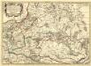
Germano - Sarmatia in qua Populi maiores Venedi et Aestiaei Peucini et Bastarnae in minores Populos divisi ad hodiernam locorum, et Redionum positionem respondent
1 : 2900000 Mollova mapová sbírka Sanson, Nicolas Covens, Johannes I
Poland.
1 : 3576320 Cummins Map Co.
Erste Theilung Polens 1772
Polen Teilung Polens <1772>
(La Pologne)
1 : 13000000 Bruyset, Jean-Marie; Schneider, J. H.
Mapa Polski
1 : 1500000 Evropa střední a východní Pokorny, Wilhelm Tomaszewski, Adam Księgarnia polska Bernarda Połonieckiego