Maps of Belarus
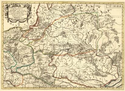
Germano - Sarmatia in qua Populi maiores Venedi et Aestiaei Peucini et Bastarnae in minores Populos divisi ad hodiernam locorum, et Redionum positionem respondent
1 : 2900000 Mollova mapová sbírka Sanson, Nicolas Covens, Johannes I
Karta voennych dějstvīj 1768 - 1771 i 1794 g.g.
Polen Krieg
Polen
1 : 1280000 Bělorusko Rizzi Zannoni, Giovanni Antonio Artaria
Polen
1 : 1280000 Bělorusko Rizzi Zannoni, Giovanni Antonio Artaria
Generalkarte von Polen, Litauen und den angraenzenden Laendern
1 : 1250000 Litva Follin, Bartolomeo F.A. Schraembl
Západní Rusko a přilehlé části říše Německé a Rakousko-Uherska
1 : 1250000 Německo východní Machát, František V. Neubert
Neueste karte von Polen und Lithauen nebst Theilen der angränzenden Länder
Litva C. Hoffmann
Das Königreich Pohlen und Grosherzogthum Litthauen
Litva
Polens Umwandelungen von 1772-1809
1 : 2100000 Polsko zu finden in der Dykischen Buchhandlung
Ethnographical map (Eastern Europe). Poland 1918
1 : 1500000 First World War ethnographical map (Eastern Europe). 1918. Four sheets, covering Germany, Poland, Northern Italy and South eastern Europe. To illustrate the post-WW1 settlement. War Office
Het Koningkryk Polen, volgens de nieuwste waarneminge opgesteld
1 : 16000000 te Amsterdam : bij S. v. Esveldt
Paasche's Frontenkarte, Nr.6. Der Krieg gegen Russland

Polen
1 : 2100000 Bělorusko Hutter, F. X. Walch, Johann bey Joh. Walch
Mapa Polski
1 : 1500000 Evropa střední a východní Pokorny, Wilhelm Tomaszewski, Adam Księgarnia polska Bernarda Połonieckiego
Polens Umwandelungen von 1772-1809
1 : 2100000 Bělorusko in der Dykischen Buchhandlung
Tableau l'historie des Royaumes de Pologne, de Boheme et de Hongrie.
1 : 6800000 Duval, Henri
Magni Ducatus Lithuaniae, caeterarumque Regionum Illi Adiacentium Exacta Descriptio [Karte], in: Theatrum orbis terrarum, sive, Atlas novus, Bd. 1, S. 84.
1 Karte aus Atlas Blaeu, Joan Blaeu, Willem Janszoon
Erste Theilung Polens 1772
Polen Teilung Polens <1772>
Erste Theilung Polens 1772
Polen Teilung Polens <1772>
Zweite Theilung Polens 1793
Polen Teilung Polens <1793>
Dritte Theilung Polens 1795
Polen Teilung Polens <1795>
Charte von Polen
1 : 2300000 Bělorusko Kipferling, Karl Joseph Artaria
Dritte Theilung Polens 1795
Polen Teilung Polens <1795>
Nova descriptio regni Poloniae et magni ducatus Lithuaniae
1 : 6600000 Litva
Poland.
1 : 5100000 Lucas, Fielding Jr.
Nr. 15. Der Krieg in Westrußland im Herbst 1915
Polen Weltkrieg <1914-1918>, Ostfront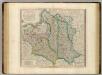
Poland, Lithuania.
1 : 2600000 Cary, John, ca. 1754-1835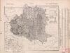
Poland: Natural increase
1 : 3000000 Series of maps on various aspects of Poland. Natural increase. Annual increase of population. War Office
Polen vor der Theilung
1 : 1800000 Polsko Goldschmidt Goldschmidt