Maps of Belarus

Karta voennych dějstvīj 1768 - 1771 i 1794 g.g.
Polen Krieg
Polens Umwandelungen von 1772-1809
1 : 2100000 Polsko zu finden in der Dykischen Buchhandlung
Paasche's Frontenkarte, Nr.6. Der Krieg gegen Russland

Das Königreich Pohlen und Grosherzogthum Litthauen
Litva
Polens Umwandelungen von 1772-1809
1 : 2100000 Bělorusko in der Dykischen Buchhandlung
Het Koningkryk Polen, volgens de nieuwste waarneminge opgesteld
1 : 16000000 te Amsterdam : bij S. v. Esveldt
Charte von Polen
1 : 2300000 Bělorusko Kipferling, Karl Joseph Artaria
Magni Ducatus Lithuaniae, Caeterarumque Regionum Illi Adiacentium Exacta Descriptio [...] [Karte], in: Novus Atlas, das ist, Weltbeschreibung, Bd. 1, S. 68.
1 Karte aus Atlas Blaeu, Joan Blaeu, Willem Janszoon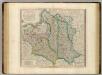
Poland, Lithuania.
1 : 2600000 Cary, John, ca. 1754-1835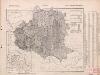
Poland: Natural increase
1 : 3000000 Series of maps on various aspects of Poland. Natural increase. Annual increase of population. War Office
Erste Theilung Polens 1772
Polen Teilung Polens <1772>
Magni Ducatus Lithuaniae, caeterarumque Regionum Illi Adiacentium Exacta Descriptio [Karte], in: Theatrum orbis terrarum, sive, Atlas novus, Bd. 1, S. 84.
1 Karte aus Atlas Blaeu, Joan Blaeu, Willem Janszoon
(La Pologne)
1 : 13000000 Bruyset, Jean-Marie; Schneider, J. H.
Magni Ducatus Lithuaniae, Caeterarumque Regionum Illi Adiacentium Exacta Descriptio [Karte], in: Le théâtre du monde, ou, Nouvel atlas contenant les chartes et descriptions de tous les païs de la terre, Bd. 1, S. 82.
1 Karte aus Atlas Blaeu, Willem Janszoon und Blaeu, Joan Blaeu, Willem Janszoon
Generalkarte von Polen, Litauen und den angraenzenden Laendern
1 : 1250000 Litva Follin, Bartolomeo F.A. Schraembl
Erste Theilung Polens 1772
Polen Teilung Polens <1772>
Estats de la couronne de Pologne
1 : 2800000 Evropa východní Jaillot, Alexis-Hubert H. Jaillot
ESTATS DE LA COURONNE DE POLOGNE
1 : 2800000 Evropa východní Jaillot, Alexis-Hubert H. Jaillot
Zweite Theilung Polens 1793
Polen Teilung Polens <1793>
Carte generale & itineraire de Pologne
1 : 5000000 Bělorusko Dorn, Sebastian Michel Gröll
Westliches Russland
1 : 2000000 Evropa východní Handtke, Friedrich Carl Flemming
Polen vor der Theilung
1 : 1800000 Polsko Goldschmidt Goldschmidt
Nova descriptio regni Poloniae et magni ducatus Lithuaniae
1 : 6600000 Litva
Generalkarte von Polen, Litauen und den angrenzenden Ländern
Polen-Litauen Schraembl, Franz Anton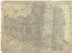
Das Königreich Polen nebst den angränzenden Ländern
1 : 1910000 Polsko Sotzmann, Daniel Friedrich im Verlag der Schneider u. Weigelschen Kunst- und Buchhandlung
Dawna polska pod względem kościelnym ewangelickim (Zbory ewangelickie, zarówno reformowane jak augsburskie i arjańskie w dawnej Rzeczypospolitej
Polen Protestantismus Lit. W. Główczewski w Warszawie
Poland, previous to 1772.
1 : 10000000 Fenner, Rest.
Poland.
1 : 5068800 Lucas, Fielding Jr.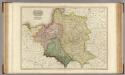
Poland.
1 : 2460000 Pinkerton, John, 1758-1826