Maps of Poland

Preussen und Warschau
Allgemeiner Atlas [Walch, Johannes] im Verlag bei Johannes Walch
Allgemeine Postkarte von der Preussischen Monarchie zur Uebersicht
Prusko Stenger, Johann im von Reillyschen Landkarten und Kunstwerke Verschleiss Komptoir
Germany, eastern border regions : administrative divisions
1 : 2570000 Inset: Major administrative divisions. "July 1, 1944, information is shown within the 1937 Germany boundary only." "No. 6275." United States. Office of Strategic Services. Research and Analysis Branch. [Washington, D.C.] : R & A, OSS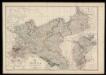
Prussia and Mecklenburg / drawn & engraved by J.W. Lowry
Lowry, Joseph Wilson Day & Son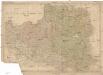
Polen
Bělorusko
Die Preussischen Provinzen Preussen und Posen, und das Konigreiche Polen
1 : 1200000 Geographisches Institut (Weimar, Germany)
Poland, Prussia.
1 : 4400000 Darton, William
Superficie de petites exploitations privées (au-dessous de 50 ha) en proportions pour cent de la superficie générale
1 : 5000000 Polsko w Biurze kartograficznem
Letecká navigační mapa

Oorlogskaart van Polen : bijzonder geschikt voor het volgen van de internationale gebeurtenissen / [cartografie] W. Seghers
1 : 1111000 W. Seghers Antwerpen : Patria ; [etc.]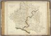
Poland.
1 : 2400000 Playfair, Principal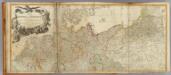
Germany (north)
1 : 1250000 Robert Laurie & James Whittle
Polen im Herzogthum Warschau und unter Oestreich und Russland getheilt
1 : 2080000 Bělorusko Mollo, Tranquillo bey T. Mollo
[Nordöstliches Deutschland]
Schul-Atlas über alle Theile der Erde nach dem neuesten Zustande, und über das Weltgebäude Stieler, Adolf Justus Perthes
Carte de la monarchie prussienne, a l'orient du Weser
1 : 2300000 Prusko Mentelle, Edme Tardieu, Pierre François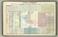
Tableau l'historie des Royaumes de Pologne, de Boheme et de Hongrie.
1 : 6800000 Duval, Henri
Prussia.
1 : 4118400 Lucas, Fielding Jr.
Mapa narodowościowa ziem Polskich
1 : 2000000 Evropa východní Maliszewski, Edward wydawnictwo Biura Pracy Spolecznej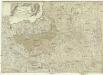
Neueste Karte von Polen und Litauen
1 : 2100000 Evropa střední a východní Müller, Franz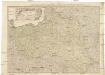
Neueste Karte von Polen und Litauen
1 : 2100000 Evropa střední a východní Müller, Franz Artaria
Deutsch-österreich-russische Grenze
Polen Grenze
Poland.
1 : 5100000 Lucas, Fielding Jr.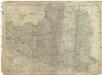
Das Königreich Polen nebst den angränzenden Ländern
1 : 1910000 Polsko Sotzmann, Daniel Friedrich im Verlag der Schneider u. Weigelschen Kunst- und Buchhandlung
Carte géologique de la République Polonaise
1 : 2500000 Kuźniar, Czesław; (Pologne) Service Géologique Lwów : Service Géologique de Pologne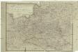
Königreich Pohlen
1 : 2055000 Bělorusko Schönberg, Johann Müller, And. Johann Schönberg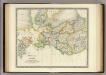
Prussia with Part of Poland.
1 : 2900000 Teesdale, Henry
Polonia
Polsko
Monarchie Prussienne.
Andriveau-Goujon, J.
Poland.
1 : 3576320 Cummins Map Co.
Prussia.
1 : 2600000 Mitchell, Samuel Augustus


