Maps of Poland

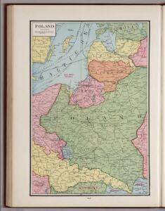
Poland.
1 : 3576320 Cummins Map Co.
Ostmitteleuropa 1923
Ostmitteleuropa Kunz, Andreas ; Treiling, Thomas
Ostmitteleuropa 1846
Ostmitteleuropa Kunz, Andreas ; Röss, Wolf ; Johnen, Bettina ; Moeschl, Joachim Robert
Ostmitteleuropa 1921
Ostmitteleuropa Kunz, Andreas ; Treiling, Thomas
Ostmitteleuropa 1937
Ostmitteleuropa Kunz, Andreas ; Treiling, Thomas
Ostmitteleuropa 1914
Ostmitteleuropa Kunz, Andreas ; Röss, Wolf ; Johnen, Bettina ; Moeschl, Joachim Robert
Polonia
Polsko
Deutsch-österreich-russische Grenze
Polen Grenze
Ostmitteleuropa 1867
Ostmitteleuropa Kunz, Andreas ; Röss, Wolf ; Johnen, Bettina ; Moeschl, Joachim Robert
Ostmitteleuropa 1793
Ostmitteleuropa Kunz, Andreas ; Treiling, Thomas
Ostmitteleuropa 1809
Ostmitteleuropa Kunz, Andreas ; Treiling, Thomas
Ostmitteleuropa 1830
Ostmitteleuropa Kunz, Andreas ; Röss, Wolf ; Johnen, Bettina ; Moeschl, Joachim Robert
Ostmitteleuropa 1807
Ostmitteleuropa Kunz, Andreas ; Treiling, Thomas
Ostmitteleuropa 1949
Ostmitteleuropa Kunz, Andreas ; Treiling, Thomas
Ostmitteleuropa 1871
Ostmitteleuropa Kunz, Andreas ; Röss, Wolf ; Johnen, Bettina ; Moeschl, Joachim Robert
[Kaart], uit: G. Freytags Übersichtskarte des Deutsch-Russischen Kriegsschauplatzes
1 : 2000000 titelvariant: Übersichtskarte des Deutsch-Russischen Kriegsschauplatzes; Annotatie: Omslagtitel: Übersichtskarte des Deutsch-Russischen Kriegsschauplatzes Freytag, G. Wien : Freytag & Berndt
Ostmitteleuropa 2003
Ostmitteleuropa Kunz, Andreas ; Treiling, Thomas
Ostmitteleuropa 1820
Ostmitteleuropa Kunz, Andreas ; Röss, Wolf ; Johnen, Bettina ; Moeschl, Joachim Robert
Ostmitteleuropa 1991
Ostmitteleuropa Kunz, Andreas ; Treiling, Thomas
Ostmitteleuropa 1795
Ostmitteleuropa Kunz, Andreas ; Treiling, Thomas
Partitions of Poland. 1918
1 : 4000000 Partitions of Poland. 1918. Partitions of 1772, 1793, 1795. Russia, Prussia, Austria. War Office
Carte géologique de la République Polonaise
1 : 2500000 Kuźniar, Czesław; (Pologne) Service Géologique Lwów : Service Géologique de Pologne
Übersichtskarte des Östlichen Kriegsschauplatzes
1 : 4500000 Osteuropa Polen Litauen Weißrussland Galizien und Lodomerien Weltkrieg <1914-1918> Verl. Gerhard Stalling, Oldenburg
Poland, Prussia.
1 : 4400000 Darton, William
Tableau l'historie des Royaumes de Pologne, de Boheme et de Hongrie.
1 : 6800000 Duval, Henri
Poland.
1 : 5100000 Lucas, Fielding Jr.
G. Freytags Übersichtskarte des deutsch-russischen Kriegsschauplatzes
1 : 2000000 Německo Kartogr. Anstalt G. Freytag & Berndt
Herzogthum Warschau 1810
1 : 20000000 Herzogtum Warschau
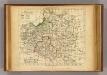
Poland.
1 : 3000000 Bowen, Frances