Maps of Poland

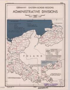
Germany, eastern border regions : administrative divisions
1 : 2570000 Inset: Major administrative divisions. "July 1, 1944, information is shown within the 1937 Germany boundary only." "No. 6275." United States. Office of Strategic Services. Research and Analysis Branch. [Washington, D.C.] : R & A, OSS
Preussen und Warschau
Allgemeiner Atlas [Walch, Johannes] im Verlag bei Johannes Walch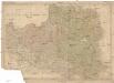
Polen
Bělorusko
Polen und Preussen 1140 - 1240
1 : 6000000 Polen, Preußen (Ordensstaat)
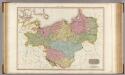
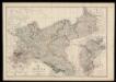
Des Preussischen Staats östlicher Theil, oder Ost- und West-Preussen und Posen
Stieler's Hand-Atlas Stieler, Adolf bei Justus Perthes
Poland, Prussia.
1 : 4400000 Darton, William
Oorlogskaart van Polen : bijzonder geschikt voor het volgen van de internationale gebeurtenissen / [cartografie] W. Seghers
1 : 1111000 W. Seghers Antwerpen : Patria ; [etc.]
Polen und Preussen 1240 - 1386
1 : 6000000 Polen, Preußen (Ordensstaat)
Polen unter Boleslaw Chrobry und bis 1139
1 : 12000000 Polen Bolesław I., Polen, König
Polen im Herzogthum Warschau und unter Oestreich und Russland getheilt
1 : 2080000 Bělorusko Mollo, Tranquillo bey T. Mollo
Tableau l'historie des Royaumes de Pologne, de Boheme et de Hongrie.
1 : 6800000 Duval, Henri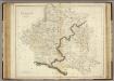
Poland.
1 : 2400000 Playfair, Principal
Superficie de petites exploitations privées (au-dessous de 50 ha) en proportions pour cent de la superficie générale
1 : 5000000 Polsko w Biurze kartograficznem
Prussia and Mecklenburg / drawn & engraved by J.W. Lowry
Lowry, Joseph Wilson Day & Son
[Nordöstliches Deutschland]
Schul-Atlas über alle Theile der Erde nach dem neuesten Zustande, und über das Weltgebäude Stieler, Adolf Justus Perthes
Carte de la monarchie prussienne, a l'orient du Weser
1 : 2300000 Prusko Mentelle, Edme Tardieu, Pierre François
Monarchie Prussienne.
Andriveau-Goujon, J.
Polonia
Polsko
Novissima Poloniae Regni Descriptio. [Karte], in: Novus atlas absolutissimus, Bd. 1, S. 90.
1 Karte aus Atlas Janssonius Offizin
Polsko, Prusy, Poznáňsko [sic]
1 : 3890000 Polsko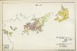
V. 1688 - 1740
Brandenburg, Preußen
87-88. Poland. The World Atlas.
1 : 1500000 USSR (Union of Soviet Socialist Republics).
Germany, eastern border regions surface configuration
Relief shown by gradient tints. Includes most of western Poland. Includes location map. United States. Office of Strategic Services. Research and Analysis Branch. [Washington, D.C.] : R & A, OSS
Charte des nordöstlichen Deutschlands nebst Preussen u. Polen
Preußen, Kongresspolen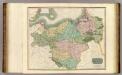
Prussian Dominions.
1 : 1450000 Thomson, John
X. Seit 1861
Preußen
Die Preussischen Provinzen Preussen und Posen, und das Konigreiche Polen
1 : 1200000 Geographisches Institut (Weimar, Germany)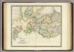
Prussia with Part of Poland.
1 : 2900000 Teesdale, Henry