Maps of Poland

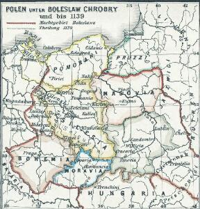
Polen unter Boleslaw Chrobry und bis 1139
1 : 12000000 Polen Bolesław I., Polen, König
Polen u. Nachbarländer 963 bis 992
1 : 12000000 Polen
Letecká navigační mapa

[XIII], uit: Geognostische Karte des Oesterreichischen Kaiserstaates mit einem grossen Theile Deutschland's u. Italien / hauptsachlich nach ... Haidinger's geognostischer Karte dieses Staates bearb. von Josef Scheda
1 : 3000000 titelvariant: General-Karte von Europa in 25 Blättern; Annotatie: Bijlage bij: General-Karte von Europa in 25 Blättern. - 1:2.592.000. - 1845-1847 Scheda, Joseph Wien : K.K. Militär. Geografisch. Institut
Polen und Preussen 1240 - 1386
1 : 6000000 Polen, Preußen (Ordensstaat)
Allemagne, Pologne, Tchecoslovaquie.
1 : 2500000 Vivien St Martin, L.
Polen und Preussen 1140 - 1240
1 : 6000000 Polen, Preußen (Ordensstaat)
Prussia.
1 : 2600000 Mitchell, Samuel Augustus
Prussia.
1 : 2600000 Mitchell, Samuel Augustus
Plastická mapa zemí Sudetských a Karpatských
Evropa střední E. Šolc
Poland & Czecho-Slovakia.
1 : 2000000 John Bartholomew and Son
Poland, 1:2,000,000
1 : 2000000
87-88. Poland. The World Atlas.
1 : 1500000 USSR (Union of Soviet Socialist Republics).
Kaart van het oostelijk front
1 : 1900000 [S.l. : s.n.]
Charte des nordöstlichen Deutschlands nebst Preussen u. Polen
Preußen, Kongresspolen
Eastern Germany, distribution of population.
1 : 2400000 Covers Poland, East Prussia, and border areas of Germany and Czechoslovakia. "From: Atlas des deutschen Lebensraumes in Mitteleuropa, plate 27. Data as of 1930-1934." "No. A-6287." United States. Office of Strategic Services. Research and Analysis Branch. [Washington, D.C.] : R & A, OSS
Germany, eastern border regions : administrative divisions
1 : 2570000 Inset: Major administrative divisions. "July 1, 1944, information is shown within the 1937 Germany boundary only." "No. 6275." United States. Office of Strategic Services. Research and Analysis Branch. [Washington, D.C.] : R & A, OSS
Carte de la monarchie prussienne, a l'orient du Weser
1 : 2300000 Prusko Mentelle, Edme Tardieu, Pierre François
Prussia.
1 : 4118400 Lucas, Fielding Jr.
Nr. 18b. Hindenburgs Züge
Polen Weltkrieg <1914-1918>, Ostfront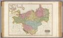
Prussian Dominions.
1 : 1440000 Pinkerton, John, 1758-1826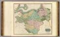
Prussian Dominions.
1 : 1450000 Thomson, John
V. 1688 - 1740
Brandenburg, Preußen
Prussian States.
1 : 3738240 Burr, David H., 1803-1875
Novissima Poloniae Regni Descriptio. [Karte], in: Novus atlas absolutissimus, Bd. 1, S. 90.
1 Karte aus Atlas Janssonius Offizin
[Nordöstliches Deutschland]
Schul-Atlas über alle Theile der Erde nach dem neuesten Zustande, und über das Weltgebäude Stieler, Adolf Justus Perthes
Charte von den Königreichen Preussen und Polen, dem Grosherzogthum Posen nebst dem Gebiete der freien Stadt Krakau. Nach dem am 3. May 1815 zu Wien zwischen Russland, Preussen und Oesterreich abgeschlossenen Tractate
Kongresspolen, Provinz Posen
Germany, eastern border regions surface configuration
Relief shown by gradient tints. Includes most of western Poland. Includes location map. United States. Office of Strategic Services. Research and Analysis Branch. [Washington, D.C.] : R & A, OSS
Monarchie Prussienne.
Andriveau-Goujon, J.