Maps of Poland

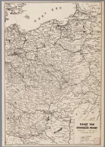
Kaart van het oostelijk front
1 : 1900000 [S.l. : s.n.]
L'empire d'Allemagne
1 Karte auf 2 Blatt : Kupferdruck ; 72 x 103 cm Brion de la Tour; Longchamps chés Longchamps géographe rue St. Jacques à l'enseigne de la place des Victoires
Germany, E. sheet.
1 : 1400000 Rand McNally and Company
B.Z. - Karte von Oesterreich

Die deutsche Bundesstaaten
1 : 3500000 Evropa střední Raffelsperger, Franz in Typographischen Landkarte-Verlage
Mittelbach's Automobilkarte von Mitteleuropa
1 : 1500000 Evropa střední Mittelbach's Verlag
Empire of Germany.
1 : 2450000 Johnson, A.J.
Empire of Germany.
1 : 2450000 Johnson, A.J.
Karpathenlaender, Polen und Preussen
E. von Sydow's Schul-Atlas in sechs und dreissig Karten Sydow, Emil von bei Justus Perthes
Fürstentum Reuß-Ebersdorf im Deutschen Bund 1820
Reuß-Ebersdorf, Deutschland Kunz, Andreas ; Moeschl, Joachim Robert
Velkoněmecká říše, Protektorát Čechy a Morava, Gen.- Guvernement, Slovensko a Švýcarsko

Deutscher Sprachtatlas
Map 10 from a 1926 linguistic atlas of Germany: Deutscher Sprachatlas, auf Grund des von Georg Wenker begründeten Sprachatlas des Dentschen Reichs ... bearbeitet bei der Zentralstelle für den Sprachatlas des Deutschen Reichs und deutsche Mundartenforschung under Leitung von Ferdinand Wrede. Marburg
Der Deutsche Bundesstaat in 23 Republiken nach Struve's Grundrechten des deutschen Volks
1 : 4500000 Lithogr. von F. Bruder in Basel Basel : [s.n.]
Eastern Germany, distribution of population.
1 : 2400000 Covers Poland, East Prussia, and border areas of Germany and Czechoslovakia. "From: Atlas des deutschen Lebensraumes in Mitteleuropa, plate 27. Data as of 1930-1934." "No. A-6287." United States. Office of Strategic Services. Research and Analysis Branch. [Washington, D.C.] : R & A, OSS
Germania Antiqua.
1 : 2300000 Robert de Vaugondy, Gilles, 1688-1766
Empire d'Allemagne, Hongrie, Gallicie, Prusse, Provinces-Unies de Pays-Bas; en 1789.
1 : 3500000 Brue, Adrien Hubert, 1786-1832
Herzogtum Sachsen-Coburg-Saalfeld im Deutschen Bund 1820
Sachsen-Coburg-Saalfeld, Deutschland Kunz, Andreas ; Moeschl, Joachim Robert
Karpathenländer, Polen und Preussen
Ostmitteleuropa Skizzenbuch
Die großen Friedensschlüsse I (1648 - 1721). 1. Westfälischer Friede 1648
1 : 20000000 Mitteleuropa Westfälischer Friedenskongress
Parte Orientale della Germania Diuisa Ne Suoi Stati
1 : 2100000 Mollova mapová sbírka Coronelli, Vincenzo Maria
Parte Orientale della Germania Diuisa Ne Suoi Stati
1 : 2100000 Mollova mapová sbírka Coronelli, Vincenzo Maria
Polen u. Nachbarländer 963 bis 992
1 : 12000000 Polen
Oorlogskaart van Polen : bijzonder geschikt voor het volgen van de internationale gebeurtenissen / [cartografie] W. Seghers
1 : 1111000 W. Seghers Antwerpen : Patria ; [etc.]
Rand McNally Popular map of Germany and Hungary
1 : 3992000 Rand McNally & Company
Polen unter Boleslaw Chrobry und bis 1139
1 : 12000000 Polen Bolesław I., Polen, König
[Historisch-geographischer Atlas zu den allgemeinen Geschichtswerken von C. v. Rotteck, Pölitz u. Becker] : Deutschland und die Gränzländer während des Befreiungskrieges 1813-1815
von Julius Loewenberg Lithographie von B. Herder in Freiburg im Breisgau [Freiburg im Breisgau] : [Herder]
Velkoněmecká říše, Protektorát Čechy a Morava, Gen.- Guvernement, Slovensko a Švýcarsko

Territoriale Entwickelung des Brandenburg-Preussischen Staates
Volksschul-Atlas über alle Teile der Erde Lange, Henry Druck und Verlag von Georg Westermann
Germany, Austria, Bohemia.
1 : 2600000 Cary, John, ca. 1754-1835