Maps of Germany

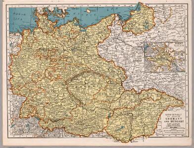
Rand McNally Popular map of Germany and Hungary
1 : 3992000 Rand McNally & Company
[Historisch-geographischer Atlas zu den allgemeinen Geschichtswerken von C. v. Rotteck, Pölitz u. Becker] : Deutschland und die Gränzländer während des Befreiungskrieges 1813-1815
von Julius Loewenberg Lithographie von B. Herder in Freiburg im Breisgau [Freiburg im Breisgau] : [Herder]
Velkoněmecká říše, Protektorát Čechy a Morava, Gen.- Guvernement, Slovensko a Švýcarsko

Velkoněmecká říše, Protektorát Čechy a Morava, Gen.- Guvernement, Slovensko a Švýcarsko
L'empire d'Allemagne
1 Karte auf 2 Blatt : Kupferdruck ; 72 x 103 cm Brion de la Tour; Longchamps chés Longchamps géographe rue St. Jacques à l'enseigne de la place des Victoires
Die Ältesten Karten von Deutschland

Velkoněmecká Říše

Mittelbach's Automobilkarte von Mitteleuropa
1 : 1500000 Evropa střední Mittelbach's Verlag
Germany
1 : 4200000 Německo
Germania magna, Rhaetia, Noricum
1 : 3800000 Evropa střední Spruner, Karl von Behrens, W. Justus Perthes
Die deutsche Bundesstaaten
1 : 3500000 Evropa střední Raffelsperger, Franz in Typographischen Landkarte-Verlage
Europe Centrale.
1 : 3500000 Levasseur, E.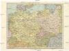
Střední Evropa
1 : 4500000 Evropa střední
Střední Evropa
1 : 4500000 Evropa střední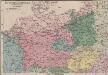
Das Sprachgebiet der Deutschen in Mitteleuropa
1 : 7500000 Mitteleuropa Deutsche, Sprachkartografie
Rozsah moci význačných českých panovníků do XIV. stol.

79-80. Europe, Central. The World Atlas.
1 : 2500000 USSR (Union of Soviet Socialist Republics).
Die Haupt-Verkehrs-Richtungen auf deutschen Eisenbahnen hinsichtlich ihrer merkantilen Bedeutung durch Farben veranschaulicht
1 : 2000000 Loeben, W.K. von Weingartner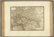
Empire d'Autriche, Monarchie Prussienne, Confederation Germanique, Pologne.
1 : 3500000 Brue, Adrien Hubert, 1786-1832
Germany.
1 : 6400000 Tanner, Henry S.
Tabula Geographica Imperii Germanici
1 : 2100000 Mollova mapová sbírka Rhode, Johann Christoph Berger, Friedrich Gottlieb
Germany general map.
1 : 4300000 Society for the Diffusion of Useful Knowledge (Great Britain)
Germany.
1 : 6336000 Finley, Anthony
Germany.
1 : 6336000 Lucas, Fielding Jr.
Germany, Austria, and Switzerland.
1 : 4092000 Gray, Frank Arnold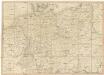
Neueste Post-Karte von Deutschland und den angrenzenden Laendern
1 : 1700000 Maďarsko Mollo, Tranquillo T. Mollo
L'Allemagne 843 a 911.
1 : 6300000 Houze, Antoine Philippe
CARTE de L'ALLEMAGNE POLITIQUE ACTUELLE a partir du CONGRES de VIENNE ou CONFÉDÉRATION GERMANIQUE, renfermant occasionellement la CONFÉDÉRATION SUISSE
Německo Hacq P. Renouard
Übersichtskarte der Eisenbahnen und Eisen-Bahn-Abstoss-Stationen von Mitteleuropa 1883
Evropa střední W. Koch