Maps of Poland

Feuille 25 (D IV), uit: Carte géologique internationale de l'Europe : la carte, votée au congrès géologique international de Bologne en 1881, est exécutée conformément aux décisions d'une commission internationale, avec le concours des gouvernements, sous le dir. de M.M. Beyrich et Hauchecorne
Annotatie: Blad 48 gamme des couleurs; blad 49: bladwijzer en titelblad Heinrich Ernst Beyrich 1815-1896; Wi. Hauchecorne Berlin : Reimer / (Berlin: Institut lithographique)
Republika polská
1 : 1000000 Bělorusko
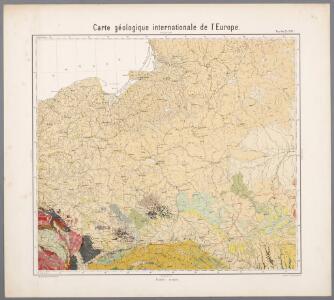
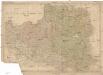
Carte géologique de la République Polonaise
1 : 2500000 Kuźniar, Czesław; (Pologne) Service Géologique Lwów : Service Géologique de Pologne
Republika Polská

Polen
1 : 2100000 Bělorusko Hutter, F. X. Walch, Johann bey Joh. Walch
Deutsch-österreich-russische Grenze
Polen Grenze
Polonia
Polsko
Charte vom Koenigreich Polen
1 : 2090000 Bělorusko Hutter, F. X. Walch, Johann bey Joh. Walch
Polen im Herzogthum Warschau und unter Oestreich und Russland getheilt
1 : 2080000 Bělorusko Mollo, Tranquillo bey T. Mollo
Kriegskarte des Koenigreichs Polen, nach den bewährtesten Hülfmitteln und den Theilungs-Tractaten vom Jahre 1773 und 1793 entworfen
1 : 2250000 entw. u. gest. von F. X. Hutter Augsburg : zu haben bey Joh. Walch
Poland, Prussia.
1 : 4400000 Darton, William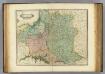
Poland, Lithuania
1 : 2650000 Lizars, Daniel
Übersichtskarte des Östlichen Kriegsschauplatzes
1 : 4500000 Osteuropa Polen Litauen Weißrussland Galizien und Lodomerien Weltkrieg <1914-1918> Verl. Gerhard Stalling, Oldenburg
Oorlogskaart van Polen : bijzonder geschikt voor het volgen van de internationale gebeurtenissen / [cartografie] W. Seghers
1 : 1111000 W. Seghers Antwerpen : Patria ; [etc.]
Polen, nach seiner ersten und letzten, oder gänzlichen Theilung
1 : 2500000 entw. u. gest. von F. X. Hutter Augsburg : zu haben bey Joh. Walch
Poloniae finitimarumque locorum descriptio. [Karte], in: Theatrum orbis terrarum, S. 103.
1 Karte aus Atlas Ortelius, Abraham
Tableau l'historie des Royaumes de Pologne, de Boheme et de Hongrie.
1 : 6800000 Duval, Henri
Nr. 15. Der Krieg in Westrußland im Herbst 1915
Polen Weltkrieg <1914-1918>, Ostfront
Poloniae, Lituaniaeque Descritpio. [Karte], in: Theatrum orbis terrarum, S. 274.
1 Karte aus Atlas Ortelius, Abraham
Superficie de petites exploitations privées (au-dessous de 50 ha) en proportions pour cent de la superficie générale
1 : 5000000 Polsko w Biurze kartograficznem
Poland.
1 : 3576320 Cummins Map Co.
Carte du Royaume de Pologne
1 : 900000 Bělorusko Nordmann, A. P. H. Gilly Artaria
Poland.
1 : 2400000 Playfair, Principal
Allemagne orientale.
1 : 2000000 Andriveau-Goujon, J.
Východní fronta 1914
Polen
Bělorusko
Charte von Polen
1 : 2320000 Halič (Polsko a Ukrajina) bey Artaria
Charte von Polen
1 : 2320000 Halič (Polsko a Ukrajina) bey Artaria
Charte von Polen
1 : 2320000 Halič (Polsko a Ukrajina) Artaria