Maps of United Kingdom

Sheet 5 Belfast, uit: Ireland
1 : 126720 Annotatie: Enkele bladen dubbel. - Enkele bladen van een oudere uitg; De bladen 5 (1912) en 9 (1918) opgeborgen bij gevouwen kaarten. - Beide bladen met aantekeningen in rode en zwarte inkt; Annotatie geografische gegevens: Reduced from the one inch map; Met diagram van aangrenzende bladen, indexdiagram van de corresponderende bladen van de 'one inch map' en diagram van 'The National Grid' Dublin : Ordnance Survey of Ireland
Die Britischen Inseln 1066 bis 1485.
1 : 3100000 Spruner von Merz, Karl
Die Britischen Inseln seit 1485.
1 : 3000000 Spruner von Merz, Karl
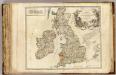
Britannicae Insulae in quibus Albion seu Britannia Major, et Ivernia seu Britannia Minor ...
1 : 2300000
A new map of the Brittish Isles shewing their antient people, cities, and towns of note, in the time of the Romans
1 : 2846000
A new map of the Brittish Isles shewing their present genl. divisions, cities, and such other towns, or places, as answer to the towns of note in the time of the Romans
1 : 2851200
Les Isles Britanniques, qui comprennent les Royaumes d'Angleterre, d'Ecosse et d'Irlande
1 : 2000000
Magnae Britanniae et Hiberniae nova descriptio
1 : 2500000 Amstelodami : apud Joannem Janssonium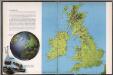
The British Isles
1 : 3000000 Debenham, Frank
Magnae Britanniae et Hiberniae Tabula [Karte] Orcades Insulae [Nebenkarte], in: Novus Atlas, das ist, Weltbeschreibung, Bd. 3, S. 358.
1 Karte aus Atlas Blaeu, Joan Blaeu, Willem Janszoon
Die Britischen Inseln bis auf Wilhelm den Eroberer 1066.
1 : 3100000 Spruner von Merz, Karl
Britania et Hibernia
1 : 3000000 Irsko, ostrov Spruner, Karl von Justus Perthes
Nieuwe en perfeckte caerte van Engelandt, Schotlandt en Yerlandt
1 : 2470000 [Amsterdam] : nieuwelijck uyt gegeven bij Hugo Allardt, in de Calverstraet inde Werrelt Caert
Magnae Britanniae et Hiberniae Tabula [Karte] [Orcades Insulae] [Nebenkarte], in: Theatrum orbis terrarum, sive, Atlas novus, Bd. 4, S. 16.
1 Karte aus Atlas Blaeu, Joan Blaeu, Willem Janszoon
Nieuwe kaart van de eilanden van Groot Brittannien : behelzende de koningryken Engeland, Schotland en Ierland / volgens de laatste waarnemingen in het ligt gebragt ; C. Sepp del. et sculps. 1743
1 : 3500000 Annotatie: Oorspr. verschenen in: Nieuwe hand-atlas ... - Amsterdam : Isaak Tirion, 1744 Sepp, C. Te Amsterdam : by Isaak Tirion
Les Isles Britanniques

Magnae Britanniae et Hiberniae Tabula. [Karte] Orcades Insulae [Nebenkarte], in: Gerardi Mercatoris et I. Hondii Newer Atlas, oder, Grosses Weltbuch, Bd. 1, S. 51.
1 Karte aus Atlas Mercator, Gerhard und Hondius, Jodocus Jansson, Jan
Magnae Britanniae et Hiberniae Tabula [Karte] [Orcades Insulae] [Nebenkarte], in: Theatrum orbis terrarum, sive, Atlas novus, Bd. 4, S. 16.
1 Karte aus Atlas Blaeu, Joan Blaeu, Willem Janszoon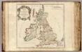
Britannicae Insulae.
1 : 2300000 Sanson, Nicolas, 1600-1667
Großbritannien und Irland
1 : 1000000 Irsko Velhagen & Klasing
Allgemeine Postkarte von Gross Britanien und Ireland zur Uebersicht
Irsko Stenger, Johann im von Reillyschen Landkarten und Kunstwerke Verschleiss Komptoir
ANGLIAE SCOTIAE et HIBERNIAE Regna
Anglie
Magnae Britanniae et Hiberniae Tabula
1 : 2300000
Magnae Britanniae et Hiberniae Tabula [Karte] Orcades Insulae [Nebenkarte], in: Le théâtre du monde, ou, Nouvel atlas contenant les chartes et descriptions de tous les païs de la terre, Bd. 4, S. 18.
1 Karte aus Atlas Blaeu, Willem Janszoon und Blaeu, Joan Blaeu, Willem Janszoon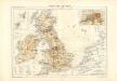
Atlas für Industrie- und Handelsgeographie: Für commercielle und technische Lehranstalten, für Kaufleute und Industrielle
Iles Britaniques routes.
1 : 2075000 Robert de Vaugondy, Gilles, 1688-1766
Magnae Britanniae et Hiberniae Nova Descriptio [Karte] Orcades Insulae. [Nebenkarte], in: Novus atlas absolutissimus, Bd. 7, S. 29.
1 Karte aus Atlas Janssonius Offizin
Grossbritannien, Ireland.
1 : 3800000 Flemming, Carl
MAGNAE BRITANNIAE TABULA
1 : 3170000 Anglie Visscher, Nicolaes Jansz. per Nicolaum Visscher


